Sunday, August 30, 2015

Kromberk - Lokve

I love riding in Slovenia.  It has a wild feeling, like nature is still in charge and the human settlements are little islands of civilization in the wilderness.  Today's ride is no exception.  I parked in Gorizia and rode into Nuova Gorica, quickly arriving at the start of the climb from Kromberk via Breg to Ravnica.  There are numerous ramps of 14-15% which is surprising given it's a military road.  At Ravnica you join the excellent road to Lokve, which gradually ascends to a a ridge line at a constant 10%.  This changes at Trnovo, where you begin a rolling ride along the top of the ridge with beautiul meadows interrupting beech and fir forest.  At Nemci you begin another steadier ascent till you reach Lokve.

Lokve seems an extension of Cepovan to the north: miles of lush green pastureland in a high valley between forested hills.  I don't blame the residents for keeping the road to the south unpaved-  this special place should be kept remote and pristine as long as possible.  The 10km dirt road isn't too bad on a road bike: on the climb I hardly noticed the difference and even on the steepest descents I avoided crashing.  Just above Predmeja the asphalt resumes and suddenly I was on one of the steepest most-fun plummets ever.  Very curvy and fast.

At Lokovec I turned to the right on a shortcut to Cesta.  From here I took the wide flattish, rolling main highway 444 all the way back to Kromberk and the car park.  Very fun ride.  In his guidebook Fulvio Babich recommends the triangle connecting Lokovec, Predmeja, and Ajdovscina so I will try that climb/descent on my next visit to this area.


Kromberk castello's vineyards 

Lokve green pastures

Edge of the forest

Through the gap Julian Alps are visible

Beginning of dirt road heading south

10 km later the asphalt returns

Near Predmeja looking down toward Lokovec

From Lokovec looking back at the mountains to the north


Last 5km of this climb are on dirt road


Friday, August 28, 2015

Monte Rite MTB

I drove to Longarone and rode my MTB to the edge of Forno di Zoldo, then turned right on the road to Forcella Cibiana.  There I found the road to Monte Rite, went around the barricade and headed up. It's dirt but the surface is good and the gradient consistently 10%.  I've read about people climbing it with a road bike and it looks possible, though the descent would be tedious avoiding sliding on the dirt and gravel.

At the top (2149 meters) the views were great in all directions except northeast, which had clouds boiling up out of Cadore valley.  Finally captured the elusive Pelmo without its cloud cover.

The ride down was fun.  I'll have to come back and try this again from Venas di Cadore sometime. Monte Rite is a great climb.

Hay drying sheds at Fornesighe

Monte Pelmo with no clouds!

View south from Monte Rite

Jagged peaks to the east of Monte Rite


To northwest Cadore valley with Cortina in distance 

Antelao to north

WW I fortress now is a museum

From Forno di Zoldo to Monte Rite summit
(max grade is wrong; maybe 14-15%)


Wednesday, August 26, 2015

Tillacher Pass MTB

I wanted to visit Val Visdende but didn't want to repeat the Strada delle Malghe from last year.  So instead I climbed from San Pietro di Cadore, up through Valle to Forcella di Zovo.  From there I descended into Val Visdende and began a gravel road climb to 2094 meters Tillacher Pass (or Passo Dignas in Italian) on the Austrian border.  It's quite steep in parts but other than a couple of very bouldery sections, was rideable.  Good views into Austria, where you can descend all the way to Obertillach on Gailtal Strasse if you have the energy.  Instead I rolled back down to Val Visdende, and bypassed Forcella di Zovo by descending directly to the main highway.  Great workout.     

The road coming up from Valle

The parallel road via Costalta which I climbed with road bike a few years ago

Forcella di Zovo, a few meters higher

Sea of clouds

Tillacher Pass is the notch high above

Looking east toward Strada delle Malghe

The switcbhacks up to the pass

Italian Army post from WW I

Austrian side of the pass

View of Austrian mountains

Porze Hutte in Austria

Lovely wildflowers along the trail


Metrics for Forcella di Zovo via Valle 

Metrics for Tillacher Pass from Val Visdende


Saturday, August 22, 2015

Two Rivers

Flat ride this morning down through Prata to the junction of Fiume Meduna e Fiume Livenza.  Very pretty area, with vineyards, church bell towers in the distance, country houses with stupendous flowers.  I'll try to add more flatness to my riding diet- seems to compliment the peaks nicely. 


The Meduna

The Livenza

Ponte San Marco d'Aviano


Thursday, August 20, 2015

Zoppe da Vodo di Cadore

I can't say I wasn't forewarned.  Most of the accounts of this climb mentioned the lengthy dirt road sections and the ungodly steepness.  But I stubbornly insisted on taking the road bike.  As it turned out the dirt roads were the easy part because they had paved the steep sections to avoid the dirt and gravel washing away.  No, the problem here for a road bike is the gradient.  My 34-30 climbing gear got me up the first kilometer or so before I stopped and walked awhile.  In fact I stopped and walked repeatedly on the first half of the climb.  Even pushing this featherweight carbon bike up the hill was making my lower back scream.  Eventually the grades stayed below 20% frequently enough so I could ride up the hill.

The scenery is beautiful dense fir trees, tumbling streams, glimpses of surrounding dolomite peaks.  Well worth the effort, though next time I will try a mountain bike.   

BTW I started from Longarone, there are tons of parking spots down by the Piave.


Antelao seen from the eaves of a wooden hay shed 

Monte San Sebastion from Tabia meadows 

Pelmo cloaked in clouds as usual

The descent to Zoppe di Cadore


Pain


Tuesday, August 18, 2015

Brugnera

Forecast called for rain all day so I didn't plan to ride, but it looked nice outside so I took off.  No particular destination, just rode around.  Ended up riding to Caneva, Sacile, Brugnera, Prata and Porcia.  Very relaxing the first couple of hours.  Then as I headed home I saw huge black thunderheads looming over Aviano.  No rain though.  Then as I climbed through Marsure a lady on a city bike came screaming down the hill and shouted "Piove in su!" to me.  I grabbed my helmet in despair.  Another guy standing in the street staring at the sky bade me "Corraggio!"  By Hotel Royal a descending road biker laughed and muttered something about our giro.  But I made it to the top rain-free, only getting uno chilometro del bagno gratis.  Not too bad.     

BTW I changed the Viner's front bearings the other day and they felt very smooth today.  May buy a set for the rear and do them as well.  Fulcrum 5 cartridge bearings seem to last me about 2 years.    

Livenza at Brugnera bridge

Livenza at Brugnera riverwalk park


Friday, August 14, 2015

Barcis- Pala d'Altei MTB

I've always wondered if it was possible to ride to Lake Barcis, climb the mountains above our house, then descend to Giais.  Today I gave it a try.  After riding up through the tunnels to the lake, I crossed the dam and turned left at Portuz.  This is the road I took a few weeks ago to Casera Pala.  From there I descended slightly and then continued to Casera Montelonga.  Took a few minutes to see where to join the trail for Pala d'Altei because the grass, wildflowers and nettles are about shoulder-high.  Eventually I found the trail heading southeast.

I couldn't ride most of this trail because of the terrain and vegetation so I pushed and carried the bike.  Over a little ridge opens another lovely meadow where I was able to ride slowly.  This soon begins climbing steeply on boulders so I pushed some more.  The terrain levels briefly as you cross a dirt road.  I will have to come back and explore this, because I'd found a similar dirt road near Casera Pala a few weeks ago and ridden it for several hundred meters.  I believe this may connect, which would save you the nettle stings of Montelonga.  I'll return and try it again.

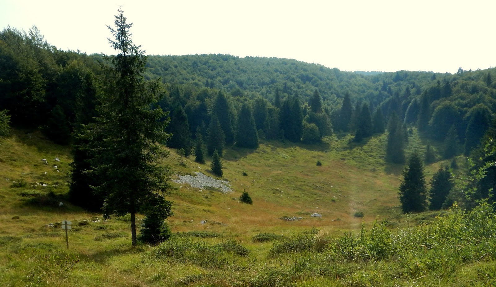
A bit more climbing and you emerge from hardwood forest into rolling alpine grassland.  This is really a beautiful spot, especially when not hazy and you can see the big mountains of Cavallo Gruppo and Ressettum (unlike today).  I continued down between Pala d'Altei and Zuccul Forador's spectacular cliffs.  More pushing the bike through shoulder-high weeds to Casera Rupiet and then I descended.  I lost my way in the little forest on the way to the gravel road but luckily ended in the right place.  

Gorgeous scenery.   Heaven is only a few hundred meters above our rooftops.    


Beech forest along the way  to Casera Pala


Finally I can pedal instead of push!
Over the ridge from Casera Montelonga

Spectacular alpine meadows near Monte Cameroni

Pala d'Altei towering above the meadows

Zuccol Forador cliffs

Pala d'Altei cliff face


Hard climb


Wednesday, August 12, 2015

Rifugio Marinelli MTB

Another ride up near the border of Carnia and Austria.  I had ridden up to Rifugio Tolazzi a few years ago on the Merckx and lately I've been reading that Rifugio Marinelli is a local MTBing benchmark.  It's now or never.

After driving to Comeglians I rode up the valley to Forni Avoltri.  From there I climbed to Rifugio Tolazzi then headed up the steep concreted road.  Lots of hikers on this trail today adding to the fun.  The trail turns to gravel and continues climbing, alternating with concrete on the steeper parts.  Soon the road veers away from the hiking trail and the surroundings begin to feel wilder.  This is one of the tougher parts of the climb, unrelentingly steeply upward.

I reached  Rifugio Marinelli at 2100 meters.  Day hikers climb up here, eat lunch and descend.  I instead followed a sign pointing east toward Timau.  The trail was too rough for me to ride so I walked down the first few hundred meters (although an awesome rider was climbing up this section, ascending the numerous vertical drops I was afraid to descend).  Soon it becomes rideable loose rock trail so I hopped back on.

Beautiful high-valleys with peaks above.  The road winds down and eventually enters fir forest with streams and songbirds.  Finally it joins the main road connecting Tolmezzo with Austria via Passo Monte Croce Carnico.  I headed east to Timau then south toward Sutrio.

My car was in Comeglians so nothing to do but climb up over Ravascletto (the ski resort town for Zoncolan) and coast down,  This is an easy climb but I was fried by now so it felt tough.  Luckily I pulled through.

This is an awesome ride.  The scenery alone is worth the effort.


Dolomiti Sappadine in Veneto

Cliffs on bottom tier of Monte Coglians (at 1700 meters)

Pian dei Buoi from Rifugio Marinelli

Alpine lake, hills at Plotta

Rifugio Martinelli with Monte Coglians behind/above

Looking back up to the rifugio from bike trail below

Monte Coglians left (2780 m), Kellerspitzen right (2716 m) 

Kellerspitzen, stretching east toward Passo Monte Croce Carnico

Looking back from near Casera Plotta

View through pass at Polinik in Austria

Passo, Pal Piccolo, Timau


Max grade is about 20%