Saturday, February 26, 2011

Osservatorio Astronomico Montereale Valcellina 2011

This is another very close climb to our house- less than 5 km away.  At Grizzo in Montereale you hang a left and then take a right onto a narrow lane marked Motel Spia.  After a bit of climbing the grade eases at Motel Spia (which has a restaurant and nice views of Montereale and Torrente Cellina).   Then it tilts to 14% for a couple of stretches, followed by several km of 8-10%.  Excellent workout.

At first you're riding in the woods encircling Monte Spia.  You can see the new dam on the Cellina at Ravedis and the steep river gorge to your right- more about this in a moment.  Then the road starts on long switchbacks along the side of Pala d'Altei, completely exposed to sun on the south.  I got  behind a slow tractor doing logging but he pulled over to let me pass when the road widened a bit- very kind of him.  Then a brief downhill, followed by a climb back into the  woods, through Val de la Roja, and finally end of pavement, after 5 km of climbing, at the astronomical observatory (670 meters).      

Beautiful descent- I tried to ride the dirt road which skirts around to the north to an overlook above the Cellina gorge, but after half a kilometer the road became too steep and rough for skinny road bike tires.  Maybe I will take the dogs for a walk up there tomorrow.  Should be a lovely view.

Frozen water trough

Catkins on hornbeam tree.  These are among the earliest flowers of Spring

Dirt road to overlook of Valcellina

Pala d'Altei, 1528 meters, from Montereale

Pala d'Altei from our house (further southwest) 

The climb from above

The grade, note 14% stretches 

Thursday, February 24, 2011

Rifugio Bornass 2011

The climb to Rifugio Bornass from Costa di Aviano is quite close to our house- starts about 5 km from home.  Normally I would ride down onto the plain to warm up, but today I had to get Marilyn to an appointment.

Immediately at the start you hit the steepest part of the climb- 1.3 km of 12.5% average gradient, with stretches above 15%.  I stood for most of this, which was good because I hadn't stretched and warmed my muscles.  After you pass Santuario di Madonna del Monte, the grade lessens somewhat and you can catch your breath.  The next 8 km to Rifugio Bornass average 5.4%, with several sections of 8-9%.  Not bad at all.

The wintery forest is pleasant to ride through at first, then after crossing Torrente Ossena, the hillside opens up and is exposed to full sun.  Here I found quite a lot of Erica (heather) in bloom.  It's especially colorful given the dead grass otherwise covering everything.

At Rifugio Bornass (a hotel and restaurant at 767 meters) you join the newly paved main road from Piancavallo to Aviano.  Beautiful road with lots of curves-  feels like you're flying!

At the bottom, I turned left and headed up Via Pedemontane toward Giais.  The rolling hills felt easy, and I made it home in time to take the pups for a walk before leaving for the appointment.


Madonna del Monte

Erica (heather) in bloom

Close up of erica blooms


Madonna del Monte with
Pala Fontana (1637 meters) in background

Map of the ride


The grade


Wednesday, February 23, 2011

Palu di Livenza


After a couple of weeks of colds, fever, rain, finally it's over.  Sunny but cold today so I kept the ride short to avoid a relapse.  Headed west on Via Pedemontane Occidentale past Trota Blu ( a restaurant surrounded by lakes, artesian fountains, ducks, swans) then turned left toward Palu di Livenza.

This is an unusual place- to the northwest, a very steep mountain ridge climbs from sea level  to 1200 meters.  At the base of this mountain range, rivers of springwater gush from the rocky cliffs.  In the valley between the mountains and a line of glacier-moraine hills lies a marshy area called the Palu.    

It's a large archaeological site where prehistoric people lived thousands of years ago. People were attracted by the area's abundant food, and plentiful reeds to build with.  It is an UNESCO World Heritage site.

Further along the road you pass behind the hills of San Floreano.  This is a lovely nature reserve of trees, animals, and lots of popular hiking trails.  At the top are meadows and a farm with sheep, horses, orchards, big vegetable gardens.  Also an agriturismo or tourist farm where people stay and enjoy country life.  

After Polcenigo I headed up the back road through Santa Lucia, Budoia and Castello d'Aviano.  The climb up through Marsure was pretty easy, even the 7-8% stretch.  I survived despite my lingering cold symptoms.   But I must remember to take a pack of fazzoletti next time- riding with a cold is quite awkward.


Monument to family blown up by Nazis  in 1945.  After Italy surrendered in 1943,
 the Germans became their enemy and brutally punished the Resistance for the next 3 years

The family's home after the explosion

Among the victims these innocent bambini

The archaeological site at Palu di Livenza

View of the Palu

The northwest side of Parco San Floreano

Castello di Polcenigo

Palu di Livenza

Lower Palu di Livenza

The forest and meadows of Parco San Floreano


Monday, February 7, 2011

Monte Prat 2011

A beautiful sunny day, cold (5℃) when I started, but warming to near-April temps by the time I got home.  After the lengthy flat ride to Lestans, I rode the rollers through Pinzano to Fiume Arzino, and started the climb.  The switchbacks up to Forgaria (320m) have been resurfaced and are great, especially when descending.  At Forgoria you turn steeply upward toward San Rocco at 419m.  Here you get a brief respite and can enjoy the views of the Tagliamento River and Monte Ragogna across the way.  Climbing up out of San Rocco, you arrive on the wonderful newly rebuilt road to Monte Prat.  This was started before Stage 18 of the Giro d'Italia descended through here in 2006, and was finally finished last Fall.  Really splendid curves and smooth pavement.

Slowly climbed by pastures with baby asinini and some beautiful chocolate brown sheep with curved horns.  Look closely in the picture below-  there is a jet black lamb lying in the sun next to her mama.  The road winds back and forth till 759 meters, overlooking the wide meadows of Monte Prat.  This section of the climb is just hard enough to challenge you, but doesn't beat you into submission.

After the pretty meadows you enter a lovely beech tree forest on a narrow mountain lane.  It ascends meanderingly to 903 meters at Val Tochel, a meadow at the base of Monte Cuar.  Monte Cuar is a very distinctive mountain you can recognize from far away, because it is shaped like a symmetrical arc of rocky cliffs with identical peaks at each end.  There are 3 ways to descend from here- west to Val d'Arzino, north through Cuel di Forchia pass  to Avesins, or back the way I came, to Forgaria.  I turned around and headed back.  After Monte Prat the great descent begins, wide sweeping tornanti, and my favorite, chicanes where you lean hard right then quickly flip over and lean hard left as you enter a 180 degree turn at the end of a switchback.  The silky smooth pavement ends at San Rocco, and the road becomes rough, but still steep and fun.  After Forgaria more newly paved switchbacks to play on till you reach Fiume Arzino.

From there it's a longish ride home, but the warm weather and sun made it seem easier.  I'll be repeating this ride (or some variation of it) soon.       

Shaggy asinino

Fuzzy baby asinino

Monte Cavallo 2251 meters

East peak of Monte Cuar 1477 meters

West peak of Monte Cuar

Monte Musi (1870m) across the Tagliamento River valley

Cuel di Forchia pass between Monte Cuar & Monte Covria

Frozen pond atop Monte Prat
Beautiful chocolate brown sheep-
click to enlarge and see black baby lamb


Saturday, February 5, 2011

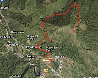
Forchia di Meduno - Monte Valinis

After finding Pala Barzana clear of snow at 840 meters, I thought I'd check out conditions a little higher up.  As I set out today it was overcast and cold, with no wind.  After a fast ride to Meduno at 313 meters, I headed steeply up a stretch of 10.8% toward Borgo San Martino.  Then the road mellows to 7-8% on up to Forchia di Meduno at 640 meters.  Lots of tractors hauling wood down from the forest today.

For the next kilometer from Forchia di Meduno to Forchia Piccola the road is almost flat, a good chance to catch your breath.  Then just as suddenly, it tilts steeply upward again, remaining constantly above 10% for 2.5 km.  The road climbs through a dense forest, shady even in February when the trees are bare.

Finally the constant 10% lets up a bit at 923 meters.   Then the pavement ends at 940 meters.  Now the road is very rocky- better suited to a mountain bike than bici di corsa with 23mm wide tires.  I managed to ride all the way up to 985 meters before encountering  a stretch of ice and snow in the road.  No snow on the surrounding pastures though.  At the  end of the road at 994 meters sat a couple of cars from Austria with hang gliders on the roof.  I saw the drivers standing on a nearby knoll- maybe deciding whether to make the leap.

The descent was very fast and curvy- fun!  Good ride.


Monte Raut, right.  In background, mountains of
Valcellina west escarpment

Frisanco, left foreground.  Poffabro, right

Emerald green Torrente Meduna,
town of Meduno in foreground

Icy pond atop Monte Valinis

Winter clouds
The grade


Wednesday, February 2, 2011

Pala Barzana 2011

Last February I tried climbing Pala Barzana and only made it to 650 meters before the snow was too deep.  But this year the snow of December seems to have melted everywhere I've ridden.  Yet I saw a "road closed" sign on the road by Andreis the other day- would I be able to cross the pass?

I climbed from Maniago and turned into Bus di Colvera gorge to avoid the tunnel.  A few hundred meters into the gorge I glanced at the river and saw a beautiful dark gray heron searching for food.  I slowed to stare and the heron must have caught a glimpse of me and took off, gently flapping his wings and slowly gliding up the canyon.  I continued to ride, constantly looking over the edge into the river.  Finally I saw the heron again, but he took off and continued up the canyon.  That was the last I saw of him, such a beautiful animal seemed out of place in an icy mountain stream, far from the warm summer lagoons of the Adriatic.   

At Poffabro I headed steeply upward to the edge of town, then down to Pian delle Merie.  Here you cross a mountain stream and head upward again.  At 650m where the snow started last February the road was closed again.  This time it was road work- they had bulldozed the broken pavement off of about 100 meters of roadway.  I walked because I wasn't sure how long the section lasted, but it looked rideable.  Afterward I remounted and continued on up to 842 meters at the Pala.  

The descent was a bit frosty so I rode slowly, and froze solid.  I stopped a few times to photograph the spectacular panorama.  At Andreis I pedaled fast as possible down to SP251, then turned left and cruised through the 4 km tunnel in record time.  Still didn't get warmed up till I got home and took a hot bath.   

Later in the afternoon I took the dogs for a walk down by the old aquadotto.  As we crossed over the bridge an eagle took off from under the bridge and landed in the tree tops.  Moments later its companion also took off and joined it in the trees.  Today was full of unexpected birds in unusual places! 


Monte Raut from the road above Bosplans 

Monte Corta left, Monte Castello right

Mountains above west escarpment Valcellina

Andreis surrounded by mountains

Monte Sestier 2080m, Monte Imuri 2049m, Monte Messer 2230m
Map of the switchbacks