Sunday, August 31, 2014

Forcella Tamer

The weather forecast called for rain starting at noon, so I decided to do a local ride with some climbs before the downfall began.  After Maniago, just before Fanna I turned left on the road up Monte San Lorenzo.  I recommend only climbing this on Sunday or holiday because on weekdays it has giant dump trucks loaded with rock quarried at Monte San Lorenzo headed for the cementificio of Fanna.  The road has some damage from heavy rains undermining the roadbed, causing a large slump.  It's a great little workout, 2.6km averaging 8%.

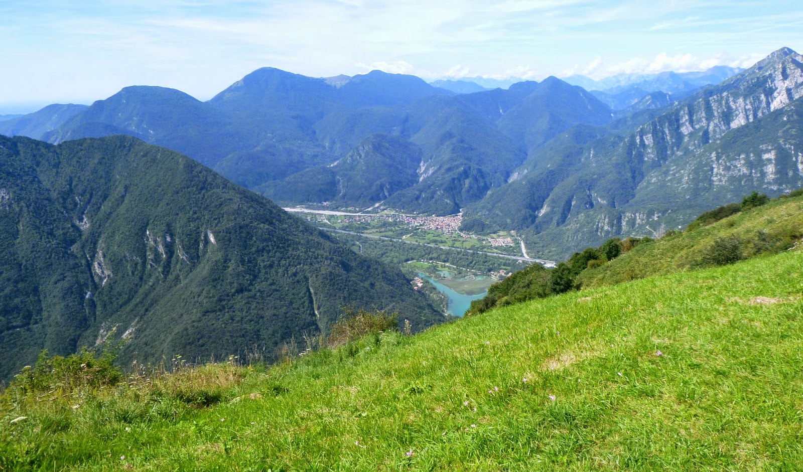
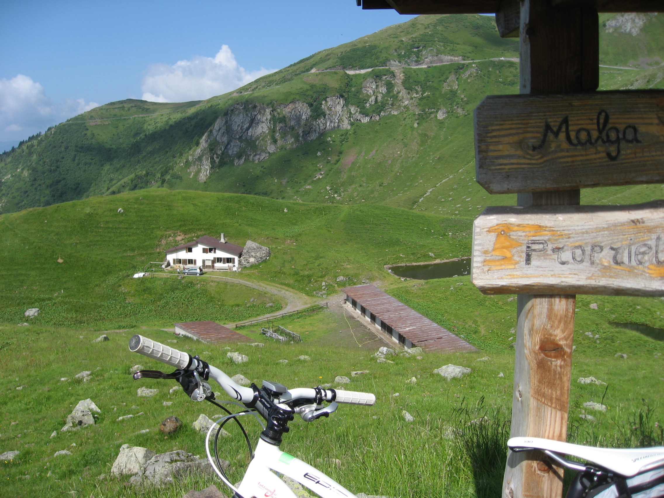
Steeply down the other side to Valcolvera, and just before Poffabro turn right down Val Muie.  Fun rolling road descending after Navarons to Fiume Meduna, then steeply up to the main road for Monte Rest.  Turn left, skirt the shore of Lago di Redona until you reach the right turn toward Campone, then climb gently up the gorge of Torrente Chiarzo.  This wonderful road eventually reaches a sharp dogleg right turn up the mountainside.  I dreaded climbing this because previously the steep pavement was mostly torn up, with wet, algae-covered slippery stones: hard to climb without standing, yet nearly impossible to get traction with an unweighted rear wheel.  Luckily after a couple hundred meters it was newly paved (I guess 1 or 2 years ago).  The surface was great and the gradient was climbable seated, in 34 X 27 gear.  The road is barricaded and marked closed because of a landslide, but they've cleared the rubble from the road and are now shoring up the adjacent slope: on a bike it's no problem.   From the start of this climb to Forcella Tamer you climb 5.5 km, averaging 9.6% gradient. 

At 900m there is a cattle gate, a short stretch of paved road, and then rocky MTB riding to 1000m where the parapendi launch at Monte Valinis.  I decided to turn around at the gate so I could beat the rain.  I descended the way I'd come all the way down to the Campone road at 432m.  

After passing through Campone I began the climb up to Piani di Clauzetto at 673m.  Descending to Pradis di Sotto at 537m I noticed an unusual number of hikers, runners.  Turned out they were having a marcia, similar to Volksmarch in Germany.  I threaded through the walkers and headed up the last climb of the day through Pradis di Sopra to Cristo at 717m.  After Clauzetto I switchbacked to Travesio, then to Toppo, across Fiume Meduna, through Fanna to Maniago and home.  The predicted rain was nowhere to be seen; in fact it was now sunny and warm.  Meno male, it motivated me to ride fast and I enjoyed the rolling ride.     

Monte Raut from Monte San Lorenzo;
I'll try to hike there from Panuch in September

The rehabilitated former quarry on Monte San Lorenzo's
northeast side; the south side is still being quarried.  Beautiful
west side is still natural, with Chiesa di San Lorenzo high
 above the cliffs along Bus di Colvera

Shoring up the landslide on Campone - Forcella
Tamer road.  Note the new pavement.


Friday, August 29, 2014

Monte San Simeone


Monte San Simeone is an annual pilgrimage for me.  Today the weather was temperate and clear, and the grifoni of Cornino wildlife reserve were making the most of it.  Don't think I've ever seen so many of them at once before.  After watching this spectacle awhile I continued up past Lago di Cavazzo to start of climb.  The climb was perfect: not too hot and the road surface wasn't as bad as I'd remembered.  After the top (1187 meters) I rolled down into some pretty green meadows with the tree-covered summit of Monte San Simeone above in the distance.  The paved road ended so I retraced a bit, then hiked up to Chiesa di San Simeone and a clearing atop the hill with a nice view. 

I descended until 375 meters, where I reached the junction for Monte Festa and turned off to check it out.  Pavement ends after 1.5km but a gravel road continues to the fortress.  I will try to mountain bike that in September or October.

Got a bit fatigued on the way home but never bonked, thanks to the unseasonable 20℃ with a light breeze on an August afternoon.

Beautiful turquoise water of Lago di Cornino

Just a few of dozens of grifoni riding the thermals
along Tagliamento's cliffs   

In clearing above chiesa looking west

San Simeone summit- must hike (maybe MTB?)

The chiesa with mountains to northeast

Monte Palantarins towers above Fiume Tagliamento (left)
and Torrente Pakar (right); another MTB ride

Southern end of Lago di Cavazzo and mountains to southwest

Hang glider taking off from the steep pastures

Monte Festa (left) with pre-World War I fortress
on top

Lago di Cavazzo, created by retreating glaciers

Pieve di Santo Stefano, Cesclans


Friday, August 22, 2014

Lama di Som - Valle Friz MTB

I've ridden these two routes previously, but separately and in the opposite direction.  Weather looked promising this morning so I gave it a try.  I warmed up on Via Pedemontane to Coltura, near Polcenigo.   I turned north through town, then turned west on Via San Michele.  This street soon leaves town climbing, then turns to a dirt road.  It switchbacks back and forth, climbing all the way up to 612 meters near Lama di Som's pastures.  Here you turn right on the paved road and soon arrive at a left turn marked Malga Pizzoc.

This is a remote road in forest, with some steep sections concreted.  Eventually you reach a little house where you ride through the folks' front yard (marked Private Property) but they didn't mind, they were busy trying to herd their pugs, chihuahuas, and mixed breed cagnetti which were running everywhere.  Afterward at the junction you turn right toward Malga Pizzoc, and shortly after that Malga Brusada.

The road continues winding upward, sometimes concreted, to Malga Fossa di Sarone.  Here is beautiful open pastureland surrounded at a distance by forested mountains.  Higher still are Malga Folador, Casera Costa Cervera, and Casera Busa Bernart.  Eventually you leave this zone of dairies and cheese makers and arrive on the forested ridge.  About this time the cool clear weather turned into clouds and fog- quite chilly.  The road deteriorates into a stony, washed out forest road.  Before long you reach Col delle Palse where the paved road from Mezzomonte arrives.  

After the brief concrete and asphalt section near Col Grande (I had road biked it last week http://dolomiti-friulane.blogspot.it/2014/08/col-grande.html ) the road again turned bad.  There was a friendly group of horses walking alongside the road but they wisely used the only decent path, so I hopped off and churned through the rock pile awhile.  Eventually you reach Casera Valle Friz at 1520 meters and continue roughly until reaching the concrete road down to Casera Campo and Sauc.  The brief paved climb to Piancavallo was followed by a plummet down to Rifugio Bornass.  Somewhere before Madonna della Monte the sun came back out and it warmed up.   I was very tired and glad to get home.    


View of area west of Polcenigo: Palu di Livenza

Little valley between morainic hills and the mountains:
a characteristic of the Pedemontane

Horses feeding in pastures at Malga Brusada

Beautiful Malga Fossa di Sarone

Malga Fossa di Sarone dairy and pond

West of Col delle Palse; the channels dug into these steep slopes
let loggers slide tree trunks down to the valley
Further downhill, the road coming up from Cultura to Mezzomonte

Some of the very sweet horses foraging along the road near Col Grande.
I will remember to bring them an apple or carrot next time.

Wednesday, August 20, 2014

Pala Barzana - Col Alto

Crazy weather today so I tried to do a quick local ride.   Up Valcolvera, Valdifrina and over Pala Barzana.  Weather was holding up pretty well so far, so I continued to Barcis and up the backroad to Piancavallo.  Still no rain but skies were menacing ahead.  After Piancavallo I climbed to Col Alto at 1360 meters, donned cold weather gear and headed down.  Light drizzle down to Castaldia and then slightly harder to Rifugio Bornass.  I headed down the back way to Costa and the rain gradually increased.  Never absolutely poured, but it was raining all the way home from Costa.  I stripped all the wet stuff off on the porch and jumped in a hot bath- good as new.  Good ride regardless- still keeping to my 34-27 gear goal.  The 30 tooth is reserved for insane steepness only.

Mountains to north of Pala Barzana descent

The valley where Andreis nests

Tortuous sedimentary folding visible in these cliffs near Andreis


Monday, August 18, 2014

Monte Faverghera

There are two paved roads to Nevegal: a relatively easy climb from Ponte nelle Alpi and a very steep climb from Belluno.  The steep climb was featured as a cronoscalata in  the 2011 Giro d'Italia.  I've ridden it once before but usually opt for the climb from Ponte nelle Alpi.  Today I decided it was time to refresh my memory and try the steep route again.  

After the warm up from Vittorio Veneto I turned left from the lakeshore toward Vich.  I had planned a back way to avoid the main road along the south bank of the Piave River, but quickly got lost and ended up on the main road.  Meno male, traffic wasn't too bad this day after Ferragosto weekend.  At the bridge crossing from Belluno, you turn south up the slope to Castions.  Not steep so far, but soon a wall looms ahead.  From 450 meters elevation to 1000 meters you average 10% gradient with no let up.  It eases somewhat south of Nevegal, then steepens again.  After Nevegal you continue another 5 km up the switchbacks to Monte Faverghera at 1360 meters.  From here I walked up the trail briefly to the cliffs overlooking Lago di Santa Croce, Fadalto, and Alpago.  Cloudy today but still spectacular.

I zoomed down the easier road toward Ponte nelle Alpi, turning right at Col di Cugnan and descending through Cornolade to the main road along the lake.  Fast descent to Vittorio Veneto and then drove home.  I did today's climb in 34 X 27 (just to see if I could)- legs very tired now.


Cloud forest on Monte Faverghera cliffs

Reflection of sea of clouds in Lago di Santa Croce

Mezzomiglio pastures through the mist above Il Cansiglio


Saturday, August 16, 2014

Col Grande

After a week of rain (and painting Marilyn's bedroom) I finally saw a chance to escape.  Col Grande is another of our highest local spots reachable on a road bike.  This climb starts at Coltura (by Polcenigo), climbs up to Mezzomonte on the main road, then follows a narrow mountain lane from Mezzomonte cemetery to Col delle Palse at 1360 meters.  Then you take a right on the ridge road, riding on rough rocks for 100 meters until pavement resumes (you could carry or push your bike over this stretch if rims/tires are a worry).  You climb on the paved road to 1460 meters where pavement ends again.  The road continues (if you're on a MTB) to Valle Friz and Piancavallo.

On the way down it got cold so I put on my arm warmers and vest.  I wished I had my leg warmers too.  There was a group of mountain bikers coming up and later, to my amazement, a road biker.  That's the first time I've seen another road biker up here in the past year or two.  Maybe word is spreading.  

Be careful of the drainage channels- they are numerous.

Fun ride.  Now if this rain will go away!


Road continues from end of pavement to Valle Friz

Beautiful view of the hillside, the pianura,
and the Adriatico shimmering in the distance.

View of northeast coast of Adriatico (Trieste, Grado) 


Monday, August 11, 2014

Panoramica delle Vette road closed

The Panoramica delle Vette ridge road from Monte Crostis to Ravascletto is closed due to landslides, falling rocks.  Very popular with road bikers and MTBers after its inclusion in the Giro stage to Zoncolan a few years ago, and last minute deletion for dangerousness (while stage was in progress).  I was planning a MTB climb from Sutrio to Pian delle Streghe and then west to Monte Crostis.  Maybe I'll try in Autumn.

http://aldorossi.altervista.org/carnia-beffa-panoramica-non-riaprira/?utm_source=rss&utm_medium=rss&utm_campaign=carnia-beffa-panoramica-non-riaprira


Friday, August 8, 2014

Casera Campo

Needed to get a quick ride in early this morning so I picked the highest nearby point you can roadbike to: Casera Campo.   Nice and cool at 0615 as I rode down to Pedemonte.  From here turn right on Via Monte Cavallo and head up the hill to Piancavallo at 1243 meters.  From the roundabout take the road  marked Sauc, then descend through the forest till you reach a clearing and turn right.  This road is asphalt at first, then later concrete.  Ride on past Casera Campo to end of pavement at 1435 meters.  On a mountain bike you can continue to Casera Valle Friz at 1500 meters, Col di Palse, Il Cansiglio etc.  Instead I turned around and headed down (watch out for the drainage channels).  Many more roadbikes ascending now that the sun was broiling the road.  Made it home before 0945.  Nice morning!

Monte Sauc (1600m) above Casera Campo

The gravel road continuing west to Casera Valle Friz

The road coming up from Casera Campo at end of pavement

Strada Venezia delle Nevi MTB trail climbing up from Dardago,
 viewed from Via Monte Cavallo (1019 meters)

Strada Venezia delle Nevi MTB trail
continues climbing to Sauc (1193 m)

Below the cliffs of Monte Sauc (1600m)
you can see Casera Campo (I forgot to
take a picture of it when I was up there)


Wednesday, August 6, 2014

Monte Dolada

A clear day!  Rode down to Vittorio Veneto and up over Fadalto to Lago di Santa Croce.  Past the lake I turned right toward Pieve d'Alpago.  Long climb through Tignes, Pieve and Plois to the start of the real steepness:  Monte Dolada.   Here I finally had to started using the 34-30 gear, yet still I  was struggling.  But I didn't stop once to rest, which may be the first time I made it up Dolada non-stop.  At the end of pavement (1495m) I panted for a moment and then began descending.  Lots of drainage channels to jump but otherwise a good road.  A guy was coming up on a mountain bike making a whirring noise: it had an electric motor.  18% grade or not, that's cheating.  At Pieve I was supposed to take a shortcut I had researched, but I was so tired I completely forgot.  So I went several km out of the way.  

At Puos d'Alpago I began the climb to Tambre and Il Cansiglio.  This is less steep than Dolada but if you're tired it's a good challenge.  After crossing Piancansiglio I climbed up to La Crosetta (1150m) and descended to Sarone.  Felt hot down here after being up high.  The hilly climb home took another hour, and then a nice soak in the bath.  Ahhh.  Good ride.

View of Alpago toward the east from Monte Dolada

Monte Dolada on left: the white house in the trees is
Rifugio Dolomieu, end of the road

Mountains to northwest 

Mountains to northeast

Lago di Santa Croce from below Pieve d'Alpago:
Col Visentin on right, Monte Pizzoc on left


Monday, August 4, 2014

Passo Valparola

A few years ago I ascended Passo Falzarego and Valparola from Caprile, then completed the loop through Corvara, Arabba and back to Caprile.  Somehow I never got around to climbing Falzarego from Cortina or Valparola from La Villa.  Today I tried to rectify that.

I left Cortina on my bike around 0730 (a quite nippley 48℉ in August!) and climbed past Pocol, Tofana di Rozes and Cinque Torri to Passo Falzarego at 2117 meters.  Then a km or so to Passo Valparola (2192 meters).  I donned my descending wear and sped down past stupendous Cima di Lago through San Cassione to La Villa (1420 m).  Crowded down here so I didn't linger long.

The climb back up to Passo Valparola was a good workout.  The traffic thins somewhat after Amentarola so it doesn't seem too bad.  Over the top I mostly coasted down to Cortina because the traffic after 11 AM was too heavy to go fast.  

Fun ride, though I do recommend starting very early in the morning.  Many tourists seem to sleep in, so you can use that to your advantage.  You can also combine either of these with other nearby passes to create numerous loops.   


Tofane di Rozes, 3225 meters

Piccolo Lagazuoi, 2778 meters 

Piccolo Lagazuoi close-up

Peak adjacent to Piccolo Lagazuoi

Marmolada glacier from Tre Sassi fortress, Passo Valparola

View to southwest from Tre Sassi fortress

View west toward La Villa, Gruppo Sella

Cima di Lago, 2654 meters

Close up of rock formations Cima di Lago