Tuesday, May 31, 2011

Vršič - Passo del Predil

The Julian Alps of northeastern Friuli don't end at the border- they continue into Slovenia.  In fact some of the most spectacular mountains of the range are in Slovenia.  Today I traveled an itinerary through the heart of the Slovenian Julian Alps.  It really is one of the loveliest places I've ever been.

I left home at 6 AM and arrived in Tarvisio (705m) at  8 AM.  The road starts out rolling, without a flat warmup.  Finally after crossing the border the road flattens out and I got some spinning time in.  At Kranjiska Gora (810m), a ski resort, I turned right and headed uphill, into Triglav National Park,  toward the pass of Vršič.  It starts out gently enough, riding through dense red spruce forest  along the tumbling river Piscnica, then steepens and begins a series of 24 switchbacks.  These aren't too bad, varying constantly in steepness.  The one oddity is the switchback ends, which are paved with 5 cm cubes of porphyry stone pavé.  I've ridden old tunnels paved with these in Italy but never tornanti.  After about the 6th one I got used to it- not that bad when climbing but they would definitely put a damper on descending.

Higher up the spruce forest yields to some large open sunny gaps, with incredible views of the surrounding peaks.  Just shy of the pass at 1611 meters, a flagman held us up (there were a few cars and motorcycles waiting).  Finally he waved us on, and the wide flat pass was pretty hectic- a bike race (with some pro teams- I saw some Radobank and Omega Pharma riders/team cars)  and also numerous quadracycles (are these called ATV's in the US?).  I got away from this racket as quickly as possible.

Down the other side of Vršič, toward Trenta the road is equally curvaceous (with another 20-something switchbacks, though the ends are paved with asphalt, not stone).  It's a bit steeper and would be a tougher climb.  Again, eye-popping vistas of Mangart and other surrounding peaks, and the deep gorge of Isonzo and Coritenza Rivers.  At 785m you cross a roiling whitewater stream called Soča, source of the Isonzo River.  So clear and beautiful- I could have stayed and explored for hours.   

It's a long rolling slightly-downhill ride through Trenta and along the river to the junction before Boveč (450m).  Here you turn right on the road for Passo del Predil.  This heads gently uphill along the Coritenza River, up to the beautiful meadows of Log Pod Mangartom (643m).  Saw a little flock of sheep lying under a shade tree, with a cute little black lamb only a few weeks old.

The road continues upward averaging 8% or so to Passo del Predil (1156m).  The road is exposed to the sun much of the way, and rock-faces along the road intensify the heat.  Wouldn't want to try this in July-August in the afternoon.  I was able to do this climb seated (other than standing to stretch), which surprised me as I had been struggling earlier on Vršič.

After re-entering Italy, the descent was blocked for about 15 minutes by some paving work, so another waiting crowd of German motorcyclists, cars, tour buses, etc.  Lovely view of Lago del Predil on the way down  Then a long mostly straight downhill through the massive scar of an old open pit iron mine along the river Slizza.  Probably the biggest heap of mine tailings I've ever seen- a man-made mountain that stretches for miles.  Finally reached the car at 1 PM and made it home by 3 PM.  


Gotta try this ride in the opposite direction soon- the scenery would seem all new, climbing where I descended before and vice versa.  And then there's the ascent of Monte Mangart....


Porphyry stone pavement of the 24 tornanti- slow to a crawl when descending

Monte Mangart (2676m)

Clear water of Soča river

Soča river with Monte Mangart far above in background

Beautiful meadows of Log Pod Mangartom, surrounded on all sides by peaks

Looking back down Coritenza river valley

Old Austrian fortress at Predil

Mountain backdrop to the Predil fortress

Gradient from Kranjiska Gora to Vršič

Gradient from Boveč to Passo del Predil

8.5% average grade up Vršič

8% average grade up Passo Del Predil

Satellite foto Kranjiska Gora to Vršič

Vršič to Soča river

Boveč to Passo del Predil


Sunday, May 29, 2011

Passo Praderadego da Valmareno

Passo Praderadego crosses the steep mountain ridge separating the Strada del Prosecco (between Vittorio Veneto and Valdobbiadene) from the Piave River valley in Belluno.  It retraces an ancient Roman road- Claudia Augusta Altinate.

The climb is a bit of a mystery.  My old Ediciclo guide says the pavement stops at 600m elevation, then you must turn around and go back the way you came.  Some old forum posts I found said the same.  But Jerry of Cycloclimbing rode it last year and said the short stretch of dirt road is pretty level and easy to negotiate on a road bike.  Only one way to find out- so I set out to try it myself.

Stupendous morning- cool, clear and calm.  All the heat and humidity was blown away by a tempesta we had the other night- with hail and rain blowing sideways because of the high winds.  The fine weather produced a bumper crop of cyclists this morning- hundreds riding on Via Pedemontane, up through Vittoria Veneto, and west on Strada del Prosecco toward Valdobbiadene.  Nice to see so many others who enjoy biking!

I rode down the Strada del Prosecco to Valmareno and hung a right.  Valmareno was having a little pedalata, with grandparents, parents, teenagers, small children all riding their bikes together, while police stopped all car traffic.  Fun to watch families riding together.  The road rises gently through the little village, and then there's a sign pointing to the right for Praderadego.   This road gets a bit steeper and soon exits the village.  After a few kilometers of approach, you begin 5 km of 10% average gradient, with stretches of 17-18%.  I stayed seated on everything below 16%.

There are numerous serpentine switchbacks snaking up the gorge walls to keep the steepness from being even worse.  Around 850 meters the road levels off and turns to dirt.  It's well-compacted though, and other than the occasional rock or mud puddle is as good as a paved road, even on a bici di corsa.  The dirt section is at the base of some spectacular cliffs, with views of more cliffs on the surrounding peaks and in the valley below.

The pavement restarts as the road begins to climb again through dense beech forest to 915 meters.  Here the landscape opens into tree-dotted meadows, with a festa today attracting a few hundred folks.  One of the stone buildings had a big griglia and people were swarming around trying to get barbeque.  I headed down the steep shady lane to Gus, on the main road to Belluno.  I originally intended to return by climbing up to Passo San Boldo, but I was behind schedule because I got a late start.  I decided it would be faster to ride via Belluno to Sella Fadalto and Vittorio Veneto.  It's longer but mainly rolling hills, vs a long climb.

Passo Praderadego is an excellent climb- has a wild, remote feel, yet is close by.  I will probably try climbing it from Gus in Belluno province next time.  It's less wild but still lovely scenery and should be a great workout.

Back toward Valmareno, and the hills above Conegliano
Here's a cool panoramic view: http://www.bellunovirtuale.com/passopraderadego1.html

Rock face above the gorge 

Sheer cliffs above the unpaved section
Rock formations above the unpaved road


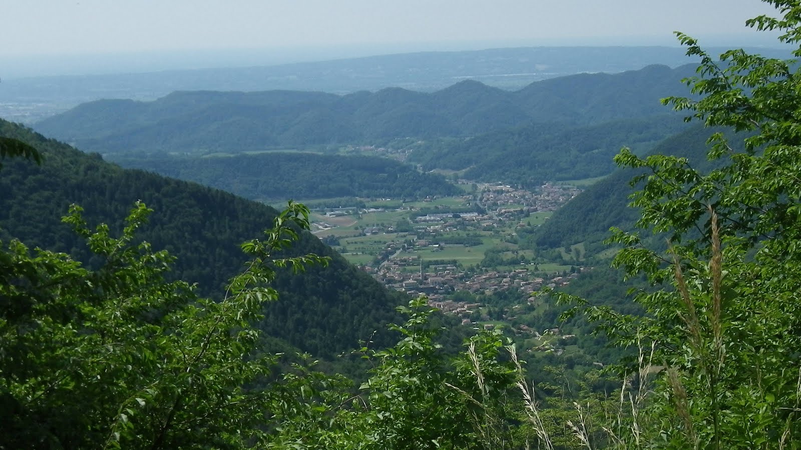
View toward Piave valley and mountains above Belluno

Satellite view
Close up of the climb


10% average gradient for 5 km


Some of the steeper bits


Tuesday, May 24, 2011

Col Indes

I've climbed up to Il Cansiglio numerous times, but never checked out this side road from Campon to Col Indes.  I left around 0730 and cruised down Via Pedemontane to Sarone, then headed up the climb.  The lower half (up to 850 meters) is mostly exposed to the sun, so I was soon quite hot, despite the early hour.  I climbed mostly seated, but stood whenever my right lower back began to ache (why it's the right I have no idea).  So the views were lovely, but the bottom half was somewhat difficult. Finally I reached the dense beech tree forest, which blocked most of the heat.  Very pleasant from here up to La Crosetta at 1130 meters.

From here a long cool descent to the meadowy altopiano at 1040 meters.  Quite beautiful this morning, with wildflowers and miles of meadow, surrounded by mountains.  After crossing the altopiano I re-entered the forest at Pian Osteria and continued to Campon.  Here I turned right onto a narrow lane marked Pian Rosada.  This is a wonderful road, completely immersed in dense Red Spruce forest, and then transitioning to tall beech tree forest, with much karst stone protruding above ground in the understory.  I exited the forest after Pian Canaie, then arrived in Vivaio and Santa Anna, where I followed the road for Col Indes.  There's a bit of climbing in these meadows, but after the climb to Il Cansiglio they seemed easy.  

Col Indes (1161 m) appears to be a disused downhill ski area, though it had a very big parking lot and only a restaurant, so maybe people come here to cross-country ski, sled. etc.

I continued up the slanted meadows to Malga di Pian Grande (1211 m), which appeared very popular, as it also had a big paved parking area, with parking ticket machine.  Haven't seen one of those at a malga before.  After Pian Lastre I continued to a stone house and end of pavement at 1260 meters.  A glorious view from here, with meadows covered in wildflowers, mountains to the north surrounding the bowl-valley of Alpago, then across the Piave the towering mountains north of Belluno.  To the west is Lago di Santa Croce, backed by Monte Faverghera, and to the south, stretches the altopiano of Il Cansiglio and Monte Pizzoc.  To the east, stand the mountains leading toward Monte Cavallo.

Easy ride back through the forest, across the altopiano, then down the descent to Sarone.  Quite hot down here by now.  I rode home and the rolling climbs seemed fairly easy, or possibly my legs had gone completely numb.  I'll definitely be returning soon with Marilyn and the pups for a hike and a picnic in that forest.  

Note: apologies for the photos- I forgot to recharge the good camera so I took the old one, which is on its last legs.


Lane through the dense red spruce forest

A grove of towering beech trees

Altopiano, with Monte Pizzoc on right 

Towns of Tambre and Spert, backed by Lago di Santa Croce

Meadows near Pian Grande, with Alpago valley and
surrounding mountains in background
See mountain ridge in background- the notch at center of foto is
Nevegal, where today's Giro d'Italia cronoscalate finishes


Sunday, May 22, 2011

Giro d'Italia on Piancavallo

Despite the tough ascent of Zoncolan yesterday, the guys don't get to rest: today's a long stage from Conegliano, up Piancavallo, Forcella Cibiana, Passo Giau, Fedaia, etc.  I knew a good steep spot (14%) on the tornanti before Bornass, where they'd be going slow enough to see them up close and get some pictures.  My neighbor Silvano came over and reminded me the race was leaving Conegliano at 1030, so I needed to get going.  I glided 7 km down to Pedemonte (178m), climbed 6 km up to Bornass (797m), and rested awhile in the shade.  There were hundreds of cyclists and other tifosi, who'd walked up after parking somewhere.  They lined the road, accumulating in tornanti-ends and any shady spots.

I rode back down about a km to the steepest point, parked the bike, and waited.  After awhile the breakaway slowly climbed by, and then small groups, then a very big group and finally more dribs and drabs who were lagging at the back.  After the race was gone I headed back down (too crowded to go fast) and then home.  Now I'm watching them climb Forcella Cibiana on RAI Sport.   It's a good stage.


Edited to add:  this morning my neighbors told me one of the fans had died yesterday trying to ride up Piancavallo to watch the race.  I remember a helicopter landed on the road and we all went around it, but I had no idea what had happened.   My sympathy to his family and friends.
http://messaggeroveneto.gelocal.it/cronaca/2011/05/23/news/dramma-al-giro-muore-un-nbsp-cicloamatore-1.62400


Le battistrade

Trying to bridge the gap to the breakaway

Danilo Di Luca 

Another gruppetto

First of the main bunch


Some of the guys struggling to re-enter the main bunch

Love the paint job on Euskaltel's Orbea bikes 

Friday, May 20, 2011

Giro d'Italia in Spilimbergo

Today's Giro stage to Grossglockner started in Spilimbergo, a town about 20 miles east of here.  So I rode down the plain, and followed the signs to the staging area.  There were team buses, team cars covered with spare bikes and wheels, etc.  I tried to get pictures of most of the teams' bikes- a few didn't turn out.  The riders emerged from their buses and were handed bikes.  They rode them up and down the shady street to warm up.  The only impression I remember was the Radobank riders- they're very big.

Then I walked into the narrow cobbled section of the centro where the riders were preparing to start.  I found a spot along the street near the gate with clock tower and waited for the start.  Everyone was laughing and having a good time.  Finally dozens of motorcycle police from Italy and Austria came roaring through, followed by race directors' cars and finally the racers.  I got a few pictures.  After the team cars, the ambulances, the alpine rescue squad, finally the Fine di Gara car passes and everyone swarms into the streets.  I hopped on my bike, headed home, and watched the racers in Austria on RAI 3.  


Kuota KOM of AG2R La Mondiale
Radobank Giant
Farnese Vini Cipollini Italian National Champion bike
Garmin Cervelo
Astana Specialized S- Works
Sky Pinarello
Bianche Oltre di Androni Giocattoli

Colnago CSF
Lampre Wilier

Movistar Pinarello Dogma
Liquigas Cannondale
Acqua e Sapone Bottecchia
Quick Step Merckx
BMC Impact
Radioshack Trek
Vacansoleil Ridley
Saxo Bank Specialized S-Works
Katusha Focus
Omega Pharma Lotto rider
Acqua e Sapone racer

Katusha team member