Sunday, July 31, 2011

Zoncolan da Sutrio

Zoncolan is the most revered Friulian climb; recent Giro d'Italia stages ending at Zoncolan have further heightened the mystic.  Most of this awe is focused on the hors catégorie western side, starting from Ovaro.  Yet the easier eastern climb from Sutrio was actually the first Giro d'Italia ascent of Zoncolan (in 2003), and it's quite challenging.

I drove north of Tolmezzo to Arta Terme, then warmed up on the easy gradient to Sutrio (534m).  Crossing the bridge I arrived at a staging area where many riders park before attempting Zoncolan.  Here I turned left and immediately headed upward at 8%.  I remained seated on this lower section, which traverses a beautiful spruce forest up a series of long switchbacks.  The road is wide and well-paved, with a fairly constant gradient averaging 8.3% for 8.7km.  I only encountered one rider headed upward, a middle-aged lady on a mountain bike.  I was very impressed that she was attempting this difficult climb- quite courageous.  She advised me to go "piano, piano" so I tried to keep my enthusiasm in-check.

This section ends at a ski resort parking area around 1300m.  Quite a few tourists up here this time of year, many from other countries in Europe.  There was no indication of a road continuing to the summit, so I asked some Civil Defense folks and they pointed upward.

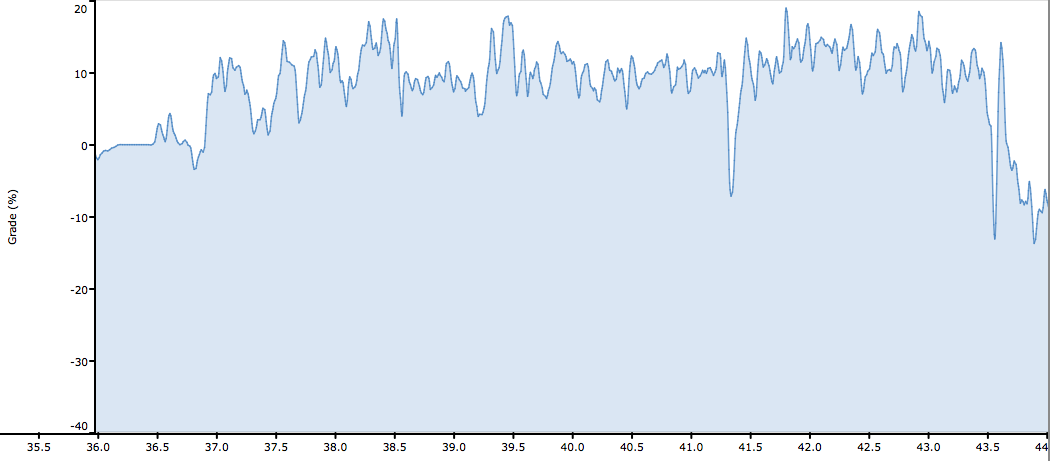
After briefly winding through the ski area, this narrow mountain road hits a stretch of 16.4% gradient, with 18.5% at points.  I climbed this standing, panting like a train.  I passed 2 young ladies hiking up, and tried to say "Bon di" and they laughed and politely returned the greeting.  The next segment of very short, steep tornanti also averaged about 16%.  I greeted 2 ladies hiking, who asked if it was "facile o dura."  I croaked out "Dura" and they laughed.  Their companion was at the next tornante; he laughingly consoled me that this stretch was very easy and the worst was to come.  Unfortunately he was right.  I held out hope and panted and gasped my way higher.  Then a section of 18.4% average gradient, with bits above 20%.  I was on my last legs here, wheezing and braying like an asino.  I thought I might have to stop, but wouldn't have room to restart and clip in, so I'd have to roll all the way down to the previous wide spot, and then reascend this wall.  So I struggled on, and then spotted some little buildings at the summit, and they seemed not too high up, so maybe the gradient was going to  ease.  Sure enough it did, and I lived.  This 4 km upper climb has a 13% average gradient.

At the top (1745m) were some tourists who had driven up. I took a few pictures of the nearly 360-degree panorama.  I headed down and soon saw the lady on the mountain bike- she was almost to the top.  I encouraged her, "Appena!" and "Brava!" then continued downward.  The ski resort area was becoming even more crowded with tourists/cars.  Now I headed down the wonderful wide smooth road, round the switchbacks and down the straights, felt like I was flying.  That was fun.  Soon, back to Arta Terme and home.

I'll try this again and see if the top is easier next time.   And maybe next year- the climb from Ovaro.... 
    

The road from Ovaro nears the summit

View to the southwest

Monte Crostis and Panoramica delle Vette road

The valley from Paluzza to Ligosullo to Forcella Duron


View east-southeast toward the Julian alps 
Dolomiti Bellunesi to west
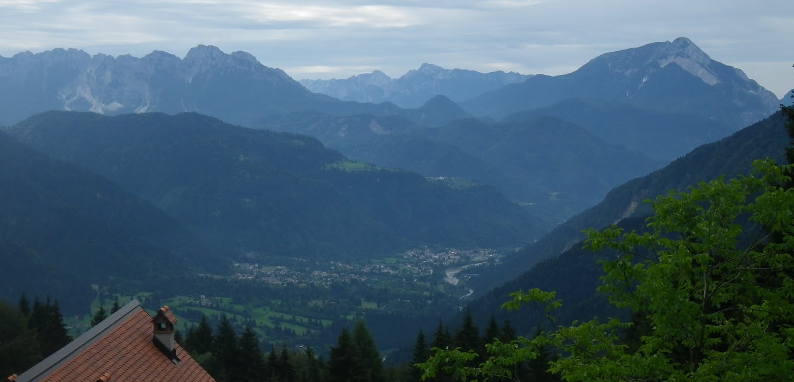
Arta Terme down the valley of Torrente But

8.3% average gradient lower climb

13% average gradient of upper climb

A couple of memorable spots on the upper climb


Wednesday, July 27, 2011

Osservatorio Astronomico Montereale Valcellina - Col Alto

Rainy weather this wek, but today a brief respite in the morning.  I decided to try to fit in two climbs close to home.  The first starts only 5 km from home, at Grizzo in Montereale Valcellina (311m).  From here a steepish climb up past Monte Spia to Val de la Roja, and then onward to end of pavement at the observatory (663m).  Didn't bring camera today, but there are pics here.

Rolled back down to Grizzo, and then cruised down to Pedemontane (155m) at Aviano.  There were thunderheads gathering around Piancavallo, but I decided to try the climb to Col Alto.  It was sunny and warm up to Rifugio Bornass (767m) but grew quite dark and nebulous by the time I reached Caldastia (1090m).  Still it wasn't raining so I turned off and took the alpine road toward Col Alto (1374m).  Almost made it all the way, but the mist kept getting thicker and eventually turned to a drizzling rain.  At 1240m about a kilometer and a half from the top I conceded and turned around.  The rain itself wasn't bad, but I knew I had a fast 15km descent and soaking wet clothes would not be good.

Back at Caldastia the rain stopped and the pavement was dry, so I enjoyed a fun descent.  The little climb from Pedemontane to home provided a nice opportunity to thaw out.  Again no fotos today, but you can see previous pics of the climb here.

My neighbor Silvano,  plotting to undermine my fitness program, arrived with a plate stacked high with home made galani (crostoli), thin and light and dusted with powdered sugar.  Yum!

Elevation of the climbs


Thursday, July 21, 2011

Cristo di Forca

This morning got off to an inauspicious start.  As I started to take my bike to the car, I noticed the rear tire was flat- odd because I'd checked everything last night.  I changed the tube and drove up to Amaro, near Tolmezzo.  Then when I got ready to ride I found I'd forgotten my cell phone- not good if you have an accident or breakdown.  I pressed on.  My original plan was to ride the old road along the foot of the mountain to Tolmezzo, but alas the ride was closed for frani (landslides) after 2 km.  So I returned to Amaro and headed up the busy strada statale.  It's nice and wide and has a wide shoulder, so it wasn't so bad.  Anyway, they say bad things happen in 3's so maybe it's true as everything else went well.

Just before Tolmezzo I turned and headed for Illegio.  This is a beautiful warm-up- very gentle gradient, wide, smooth pavement, gorgeous scenery.  I passed a large, popular rock-climbing area, deserted this early morning.  Further up the road passes through a lovely forested gap, then enters the open meadows approaching Illegio.  Really pretty place.  After the town the road heads into the forest and gets a bit steeper and narrower, with rougher pavement.  Lots of stream-crossings (some on bridges, some guadi or fords).  The steepness increase, with short switchbacks grappling up the little gorge.  At 860m the road was completely blocked by a huge truck and a crane placing refrigerator-sized blocks of stone or concrete along the road edge.  No way around, so I turned back.  I'll return to try this again- the end of pavement is at Pra di Lunge (925m) about one kilometer up the road.  

The descent was great fun on the smooth curves.  Then down SS-52 to Amaro, and the real climb begins.  I turned left, passed the church/cemetery, and shortly afterward the gradient steepens.  The road is basically 20 tornanti right up the side of a rocky mountain, climbing 650 meters in 6km.  Numerous sections above 14% (around 18% at times). There are some nice trees providing shade, but most of it is exposed to the south.  Luckily we are having a cool spell, so not bad at all this morning.  Most of the steepest parts are paved in concrete with grooves machined into surface for traction (drainage?).  Not bad at all.  And the asphalted sections are mostly smooth and in good condition- it's a surprisingly well-maintained road for so little traffic.  I came across one mountain biker descending- otherwise it was deserted.  


The highpoint is a narrow notch between 2 mountains called Cristo di Forca (1058m).  The pavement continues downhill from here then dead-ends eventually (see Jerry's description at www.cycloclimbing.com ).  I rolled down to a gravel parking spot where people start their hikes up Monte Amariana (1905m).  From here I snapped a few pictures, then headed back.  I descended fast on the straights but took it easy through the tornanti.  

Both these climbs are quite fun- highly recommended!


Rio Frondizon above Illegio

Chiesa di San Floriano above Imponzo- hike described
at http://www.camminodellepievi.it

Looking southwest across meadows near Illegio

The meadows looking west

Rio Maggiore tumbling down from Monte Amariana

Southeast toward Amaro, Torrente Fella (from left) and Torrente Tagliamento

From Cristo di Forca looking southwest at Cavazzo Carnico and Sella Chianzutan

Monte Amariana above Cristo di Forca

Map of the ride

The climb toward Pra di Lunge

Climb from Amaro to Cristo di Forca

The 2 climbs- note the >10% average gradient on Cristo di Forca ascent

Note numerous 14-18% stretches on Cristo di Forca climb

Tuesday, July 19, 2011

Kolovrat da Kobarid

Drove to Ponte San Quirino east of Cividale, and rode up beautiful Valli del Natisone to Slovenia.  Wide smooth road through the forested hills along the river, completely deserted at 7 AM today.  Maybe later in the day it's more crowded.   Very easy rolling warm-up- I think it gained only about 100 meters in 20 km.  Once in Slovenia the valley opens into wide green meadows, morning mist rising, foals following their grazing mothers.  I stopped to take a picture and heard some scurrying in the brush- a pair of yearling deer appeared.  This area of Slovenia is really gorgeous.

You leave the Natisone River behind and now approach the Soča River (Isonzo in Italian) at Kobarid.  This town was the site of a big turning point in World War I.  The Germans (and Austro-Hungarians) found a weak spot in the Italian defenses and broke through.  The entire Italian army then had to fall all the way back to the Piave River (in Veneto) to establish a new defensive line.  I skirted the west side of Kobarid and arrived in Idrsko.  Here the climb to Kolovrat begins.   

From Idrsko (210m) up through Livek to Kolovrat the road gains 930 meters of elevation in just over 10 km.  The first 4 km to Livek (690m) are the worst, with numerous stretches above 14%.  I stood on these steep sections, panting and gasping.  Luckily it was quite overcast so I didn't overheat.  On a bright summer morning this sun-exposed slope could be tough.

At Livek the road actually gets flat for a few moments.  Beautiful houses with wooden balconies covered in geraniums here.  Now the road turns upward again, but for the most part stays between 10-13%.  Still hard, but I could remain seated and breathe.  Near Monte Kuk the road tops out at 1148m.  Now it continues rolling up and down along the ridge of Kolovrat.  A small cadre of cows grazing along the narrow road were blocking the way, so I tried to gently encourage them to gather on one side or the other.  They got spooked and started trotting along the road.  I tried to reassure them of my harmless intentions ("I don't even eat hamburgers!") but couldn't sway them.  Eventually a gap opened and I accelerated through.  Felt bad about making them move several hundred meters down the road, but hopefully they found some good forage there as well.

Now the road curves west and climbs up into Italy at Solarie.  I began a wonderful counter-clockwise circuit along the side of Drenchia's bowl-shaped valley, then through Cras and steeply down the smooth, steep switchbacks to Clodig.  From here a gentle downhill ride to Ponte San Quirino.   Great climb and a fun ride.


Sorry for lack of fotos- camera battery died before Kobarid.

Misty cliffs above meadows in Slovenia

Little deer in woods near the meadow's edge 

Broad meadows stretching west from Kobarid toward Italy

Little farm below hillside

 4 km of 11% average gradient Idrsko to Livek

3 km of 10% average grade Livek to Kolovrat

14% stretches up to Livek / 12-13% bits up to Kolovrat

Map of climb from Walks of Peace in Soča Region


Map of the ride

Sunday, July 17, 2011

Meduno - Barcis

The weather has been quite tricky this week- partly cloudy with random showers.  Finally decided instead of driving somewhere and getting soaked I would just risk it here.  So I rode from home to Meduno.

From there I rode up the little valley from Navarons to Poffabro.  Then up over Pala Barzana.  The road is marked closed, but was fine: only 2 short stretches of sterrata at 650 and 720m.  The signs did cut down on the usual summer weekend tourist traffic though.

After descending to Lago di Barcis I headed up the climb to Piancavallo.  This road was also marked closed, and after 3 km of climbing I reached the barrier at 630 meters, just after Pezzeda.  They weren't kidding this time- the temporary gate is located on a bridge over a stream, so no way of going around it.  Even the bolts holding the gate's u-bolts to the guardrails were welded in place- they thought of everything.

I turned around and headed back down to the lake.  Lots of tourists walking their dogs etc along the quiet road around the back of the lake.

Rode fast as possible through the tunnels toward home.  It looked like it had just rained on the bridge over the new lake at Ravedis, but I stayed dry other than a little spray.

Ended up with only 1000m of climbing as opposed to 2000, but that's ok- they've got to fix the frani (landslides) so we can ride the back way up the mountain in future.


Elevation of Pala Barzana and truncated climb up Piancavallo

Tuesday, July 12, 2011

Mangart

Monte Mangart is just across the Slovenian border from Altopiano Montasio in northeast Friuli.  Loved by local cyclists for its beautiful alpine environment, its smooth pavement and flowing switchbacks, but most of all its relentless 1360 meter elevation gain in 15km.  A must climb if you're in the area.

I started from Vedronza (319m), a bit northeast of Udine, and warmed up in Val Torre, gorgeous green valley surrounded  by mountains.  After Passo di Tanamea (870m) I descended to the Uccea River on the Slovenian border(570m).  Unknown to me, the climb out on the Slovenian side is quite steep up to 720m, then descends down to Zaga at 370m.  Ascending this climb would be trouble later.

Pretty rolling country in Slovenia, with countless crystal-clear white water streams and rivers.  After Bovec I climbed up past Kluže Fortress along the Koritnica River.  At 597 meters you pass through Log Pod Mangartom, continuing across its meadowy valley.  Soon this road steepens for a long haul up to Strmeč at  1030m, and just above that, the turn off for Mangart.

The spectacular Mangart road starts on sun-exposed slopes and then climbs into thick-trunked beech tree forest.  The shade cools thing off, but the steepness never abates.  There are 5 short unlit tunnels, only one of which was long enough to use the flashlight I brought along (though I kept my taillight on continuously).  Higher up you eventually leave the trees and enter alpine meadows with gorgeous wildflowers.  

Near the summit, a flock of goats was conducting a sit-down strike on the road, calmly chewing their cud.  A young Slovenian couple's toddler fed chunks of carrot and cauliflower to the hungry goats.  The road tops out at 2084m with a little loop road.  Beautiful views in all directions from here.

The descent was fun but almost too long-  nearly all the way down to Kluže (about 30km) before it levels out, climbing slightly.  Now the rolling bit from Bovec to Zaga, and the tough hot climb up to 720m above the border.  I think this was the hardest part of the whole ride because my legs/lower back were fried.  Gentler climb back up to Tanamea but even that was a struggle today.  I coasted down to Vedronza and drove home, bone tired. 


Kluže fortress from WW I

Koritnica River in deep gorge at the fortress

Waterfall at the mouth of valley climbing toward Mangart

Looking southwest from around 1700m

Tall steep cliff face above the switchbacks

Around 1900 meters, the road dwarfed by another huge cliff face;
this section was the site of the goat sit-in

Main peak of Mangart to the east (2679m)


To the southeast, Log Pod Mangartom's grassy meadows far below

These beautiful wildflowers were everywhere near the top

Garmin reading about 70m low- my fault,
should have manually set starting elevation.

The climb

Approach to the climb from Italy

From www.salite.ch