Wednesday, April 29, 2015

Sella Chiampon


Finally cleared up so I headed for the hills.  I rode to Pinzano and then climbed to Anduins and the road through Val Arzino,  one of the most beautiful and uncrowded places I've ever been.  After Pielungo and San Francesco I began the climb toward Sella Chianzutan.  I thought I would continue to the top, but surprisingly the turn-off through Val Preone and Sella Chiampon was open.  Last year a huge avalanche had closed the road but now its's good as new.  I enjoyed the views, then headed down through the town of Preone to Socchieve.  Here I headed west on the main road toward Ampezzo, turning left just after Mediis toward Priuso.  Pretty good 200 meter climb here, which you immediately give back when you descend to the Tagliamento bridge.  Now the real climb starts, up the north side of Passo Monte Rest: 5.6 km averaging 8.8%, with a ramp of 14.6.  After that down to Tramonti, Meduno, Maniago and home.  Fun ride!


Looking down through beautiful Val Arzino

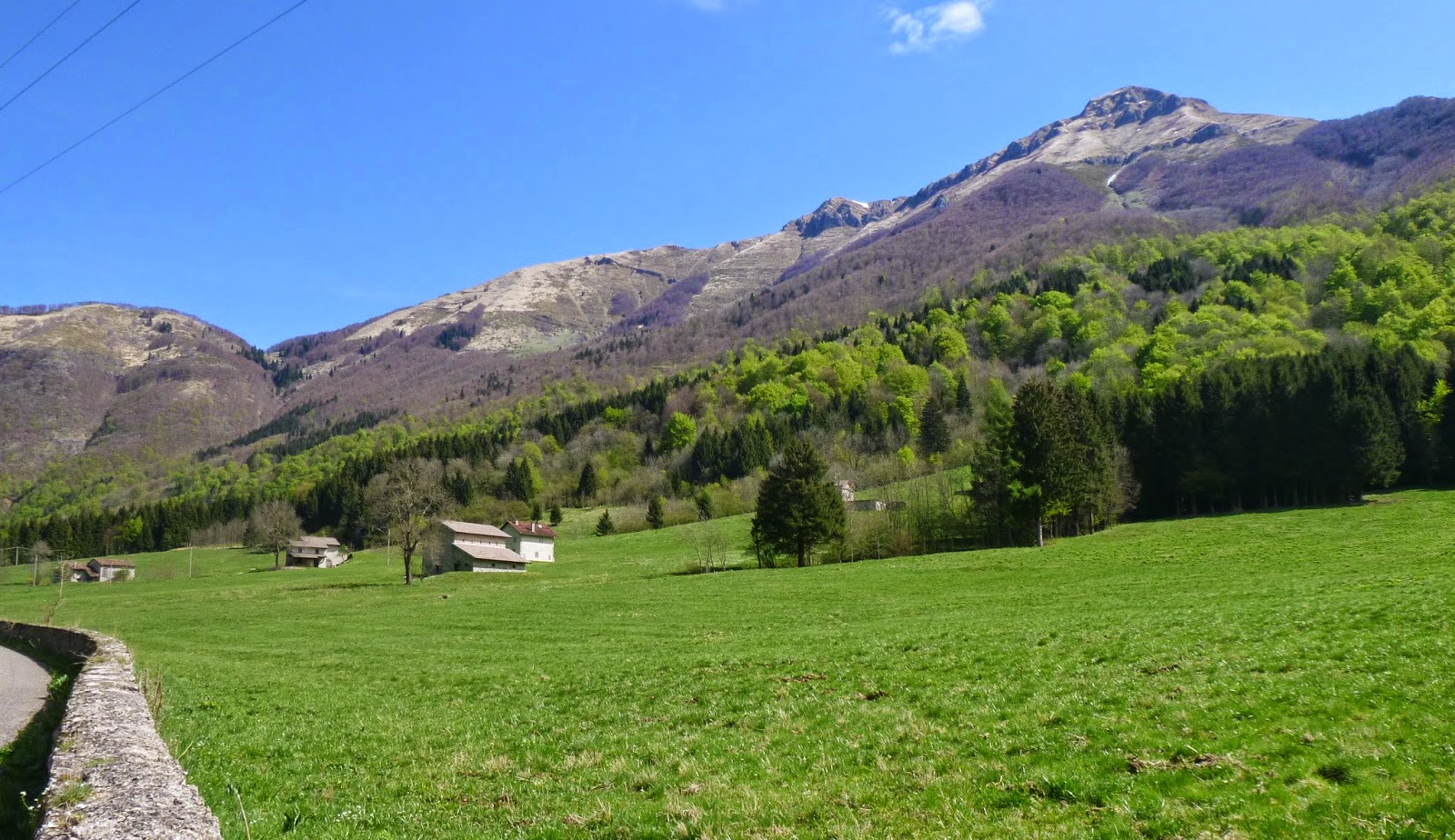
Close up of mountains further down the valley.

Pozzis along the Arzino

Sella Chiampon meadows (sorry about the thumb)

Sella Chianzutan peaks seen from Sella Chiampon

Peaks from another angle

The notch is Sella Chiampon (seen from Socchieve)

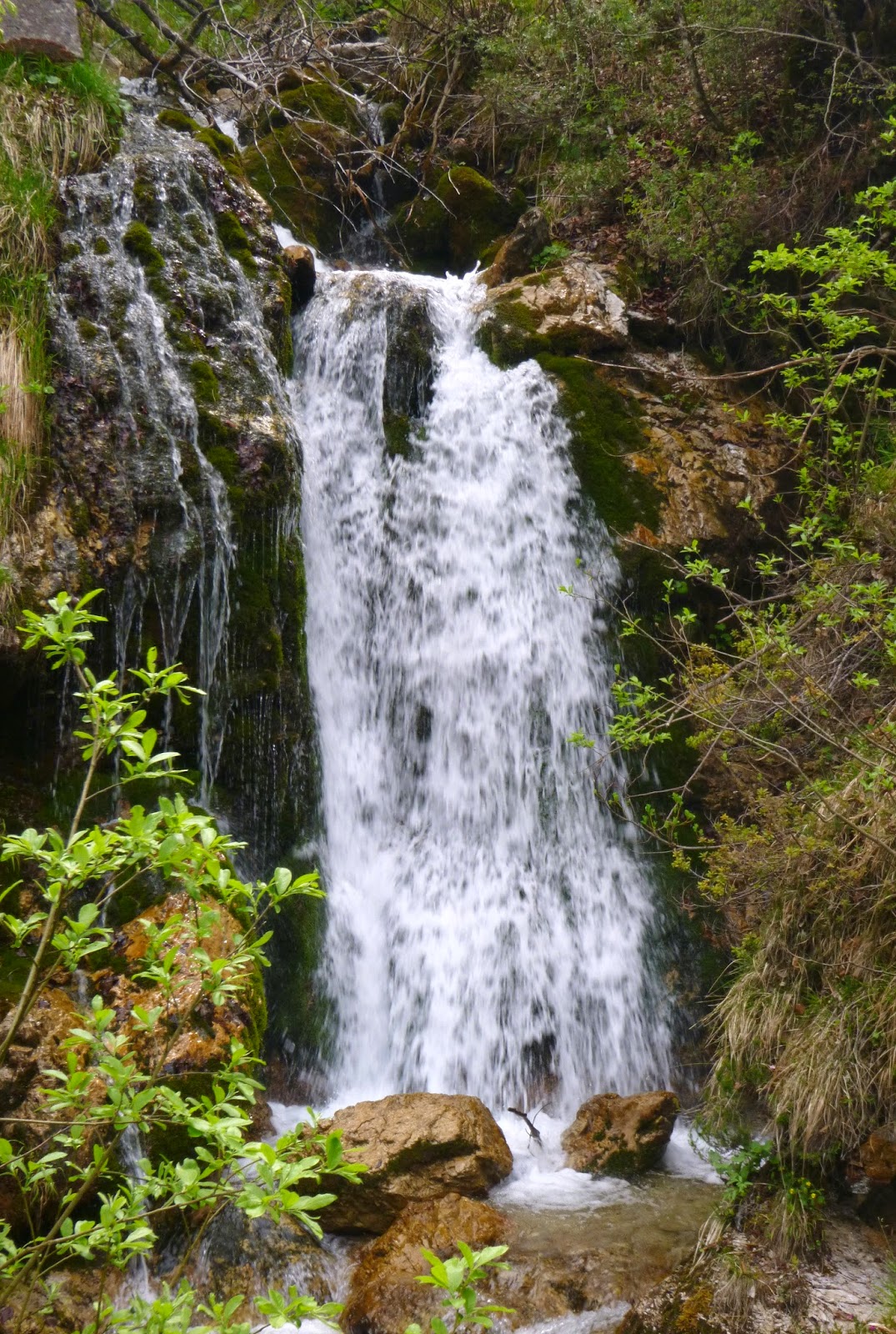
Waterfall at the start of climb up north side of Passo Monte Rest


Climb stats up north side of Passo Monte Rest


Wednesday, April 22, 2015

Monte Cereis MTB

The paved road from Meduno to Monte Valinis is a frequent local climb; I'm guessing I've done it 20 times.  But along the way several gravel roads branch off into the hills.  I've always wanted to explore them.  Today I tried the first, which veers off to the left at Chiesetta Alpini in Forchia di Meduno (630 meters).  After an intro it heads up steeply, gradually circling round the flanks of Monte Chiarandeit.  I thought there would be a trail leading to the summit (1079 meters) but I never found it.  The top looks pretty rocky so I think it may require scrambling up cliffs- will study further.

Instead, I continued  down then back up to Monte Cereis (961 meters).  The gravel road makes an interesting loop through the karst, sinkholes and trees.  At the top is a grassy pasture with a heliport marked off.

I descended back the way I'd come, taking a break at Stalla Cereis, a stone house with great views of surrounding mountains and valleys.  You can see Lago di Redona through the trees but I couldn't get a clear shot of it.  Great ride!


From near Cavasso Nuovo: left Monte Chiarandeit,
center Monte Mulon, right Monte Valinis

Frisanco, Casasola, Monte Raut

Chiesetta Alpini at Forchia di Meduno

I took the left gravel road (to Monte Chiarandeit);
the right ends at a settlement called Ferrara

View of Chiarandeit from Stalla del Bianco (hunting cabin).
It appears to be a big rock scramble with trees.

From Cereis: Cavallo Group, Poffabro, Monte Raut

View northwest

Monte Celant

Monte Raut.  Last fall I hiked up to the notch
you see below the snowcap, Forcella Capra

From Stalla Cereis: Il Von (1147m)

Stalla Cereis 

The road on cliffs above Torrente Silisia to Lago Ca'Selva

Primula bouquet surviving in a shady spot


Sunday, April 19, 2015

Bocchetta di Sant'Antonio

Beautiful and sunny today, but about 10 degrees cooler than last week.  I headed east, through San Daniele, Coloredo and Trecisimo to Faedis.  I originally planned to ride to the Slovenian border at Robidisce, but ran out of time.  I knew once I got there I'd want to continue to Napoleon's bridge and by the time I got done I'd be cutting it too close.  Still had lots of fun.  The countryside east of San Daniele is rolling green hills, several with castles on top.  At Bellazoia west of Faedis I inadvertently got on a rough dirt road, Via Stentaria.  Some Friulian mountain bikers said "Sci gu!" and laughed which I haven't looked up yet but I'm guessing is obscene.

Back on pavement I headed up through Canebola to Bocchetta di Sant'Antonio.  It's only 5 km to the border but I was uncharacteristically prudent and turned back.  Good ride home- I didn't bonk!

The road continues up to Madonnina del Domm (960 m)

View of Faedis and the plain stretching to the Adriatico

Chiesetta di Sant'Antonio; the road upward goes to Subit and Porzus,
road to Slovenia to right, road down to Faedis on left.

To north, snowy Jof di Montasio towering over the wall of Monte Musi


Sunday, April 12, 2015

Via Borgo Val MTB

This is another of the killer climbs up the mountainside above Caneva, Sarmede, Fregona.  The climb starts halfway between Rugolo and Montaner in a tiny settlement called Borgo Val.  If you find Santa Barbara Orthodox Church you're in the right place.  The road is concrete and starts off with a nearly 20% wall.  It wasn't too bad on the MTB.  The concrete road switchbacks up to 500 meters elevation at a stone house called Casera Col de Fae.  

I headed back down a ways and turned onto a gravel road headed west.  This ended up at Chiesetta del Santo.  There was sign with a map showing a trail ascending to Lama Rossa, so I pushed the bike up the exposed rock until reaching another good gravel and concrete road.  This continues to Lama Col de Fae at 585 meters.  The trail (Sentiero Pagnoca, CAI 1061) resumes here but I decided to turn around.  I went a bit past the turn off for the trail to Chiesetta del Santo and soon reached Via  Guitcillo da Montanar, which I explored a bit.  Have to come back and hike from Lama Col de Fae to Casera dal Cin.   

Santa Barbara Orthodox Church, Borgo Val

View west
Casera Col de Fae


Chiesetta del Santo

Altar of chiesetta

Sentiero Pagnoca map


Wednesday, April 8, 2015

Via Guitcillo da Montanar

I rode down Via Pedemontane to Caneva, with a guy drafting on me from Coltura to Caneva.  This surprised me because I usually get passed, but I didn't mind because it helped me concentrate on my riding.  My mind usually wanders on the flats and I slow down too much.  From Caneva I continued to Sarmede and Montaner, where the killer climb begins.

I've climbed this on a MTB a couple of times but never with a road bike.  Very hard: the worst bits I had to walk.  Still it was fun.  The dirt and grass surface higher up was no problem.  Great views from up there: less haze than usual.  On the descent I came around a bend and a camoscio (chamois) in the road jumped about 3 meters straight up onto a cliff face.  Pretty amazing.

On the ride home I was in a daze.  I tanked up on water at Caneva so hydration wasn't a problem.  Maybe lack of electrolytes?

Anyway I'll return soon on MTB to investigate Via Val Borgo, a dirt road which also climbs up into this zone.  The easy access and remoteness of this area keep luring me back. 


Chiesa di Montaner from 500 meters

The road bike by lovely restored stone farmhouse

Chiesa di Montaner from 700 meters


Monday, April 6, 2015

Monte San Lorenzo - Panuch

Clear, cold Pasquetta morning, with Bora winds from Trieste due in the afternoon.  I started by riding toward Fanna, then turning left on Via Vals, the road over Monte San Lorenzo.  At the high spot on the road, 470 meters, I stopped for a foto of Monte Raut then headed down the other side, steeply descending to the road coming up from Maniago along Torrente Colvera.  I skipped the turn for Frisanco, instead taking the next right for Navarons.  This rolling road along Torrente Muie is a joy to ride.  After Navarons it dips down to cross Torrente Meduna then climbs to meet the road toward Monte Rest.

At the Lago Redona dam turn left and recross the river.  Continue to Chievolis, crossing Torrente Silesia and continue up the climb to Lago Ca' Selva.  The dam water level was quite low compared to last year.  Maybe some Spring rain will make up the difference.  Cross the dam and continue on the gravel road (rideable with 23mm slicks).  Soon it becomes paved again and heads steeply upward.  Quite a tough climb: 1.2 km of 12.6% median and 17.5% max.  The high point is Panuch at 615 meters with a paved road heading down to the Strada degli Alpini trailhead.  At Panuch is the trailhead for Casera Valinis and Monte Raut.  I will try hiking this later in summer to see if I can summit on this route (from Pala Barzana I only reached Forcella Capra).

Ride home was fast though the Bora was already picking up speed.

Monte Raut from Monte San Lorenzo pass 

The higher bridge across Torrente Silisias.
Quite spindly looking from this angle.

Trail from Panuch toward Monte Raut

Top end of the lake where trail for Strada degli Alpini starts

The sluices on the left are dry, creek is low

Tough climb from dam to Panuch