Wednesday, June 30, 2010

Sella di Razzo


After 4 days of painting the living room, I finally escaped and got to ride. I set my alarm for 0500 and left at 0730. I parked at Villa Santina (360 meters) and rode the bike up to Ampezzo (559 meters). Then turned off on the road for Sauris. It snakes up the gorge of Torrente Lumiei, climbs a set of tornanti up to 779 meters, and then starts a series of tunnels. They are paved with small porphyry blocks, but are no problem to climb. Between tunnels are beautiful views of Lumiei gorge, particularly at Ponte Lumiei- a high bridge resembling Bixby Bridge near Big Sur. At 981 meters the last tunnel ends at Lago di Sauris, a beautiful emerald green lake surrounded by mountains.

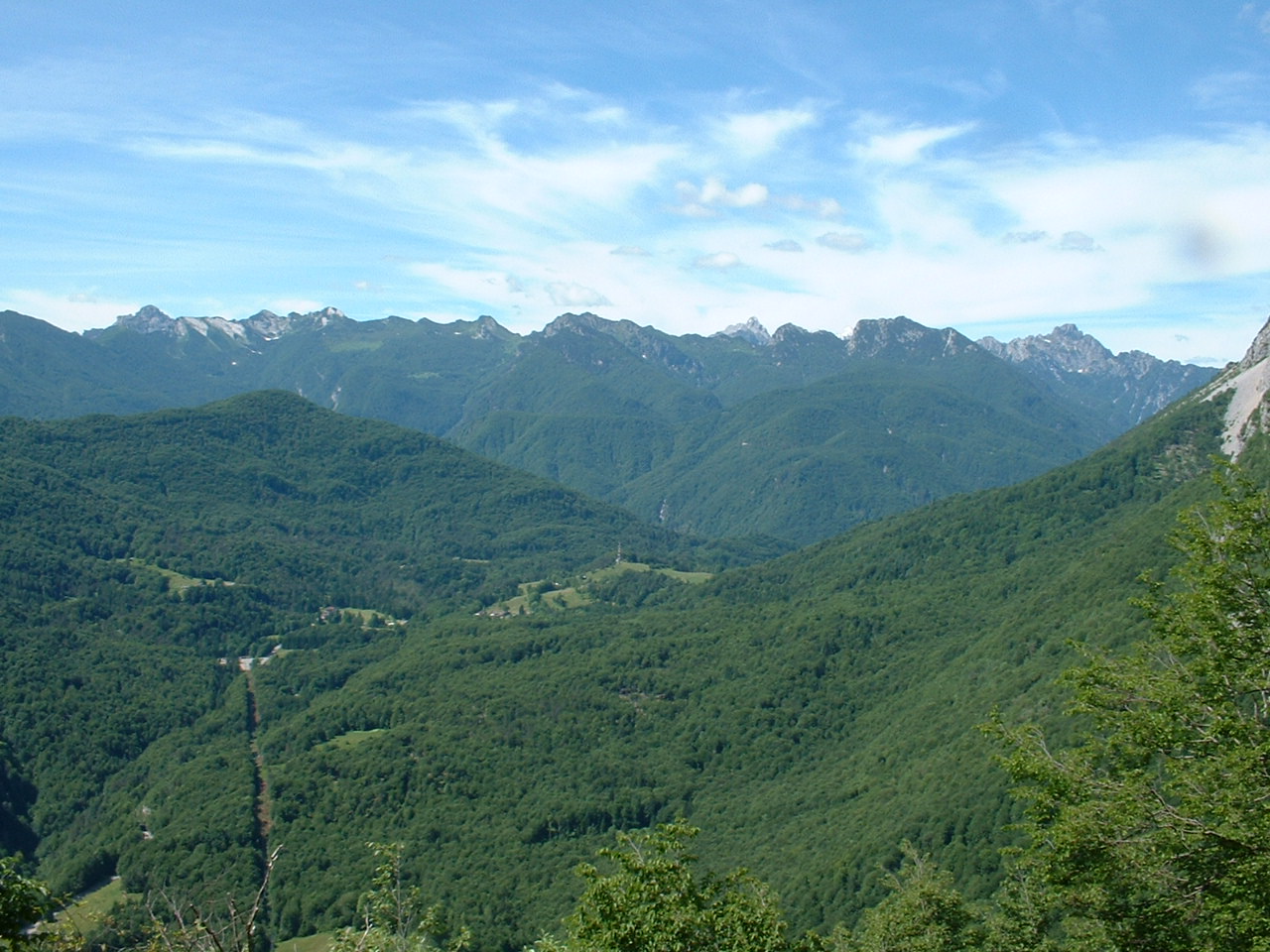
Now a steep stretch with 11 tornanti carries you up to Sauris di Sotto (or Dörf in German) at 1200 meters- beautiful green pastureland, houses with wooden balconies covered in flowers. Above Dörf 2 Italian ladies were taking a passeggiata and spurred me on with "Buone gambe!" Soon you reach Sauris di Sopra, the highest town in Friuli at 1395 meters (Zahre in German). The road mellows out a bit then reaches the start of the 7 tornanti at 1500 meters. These are a nice steady 7-8% with beautiful panoramas, until the last 2 switchbacks, which get steep- I had to stand for these 2.

The top at 1800 meters is an altopiano with wildflowers, stupendous views of the surrounding peaks. I had a snack and enjoyed the view. I then began the 1270 meter descent- a 27 km twisty cruise through fir forest and Val Peserina. Really gorgeous ride. I'd love to ride it in the opposite direction soon.

There were quite a few cyclists on this road, (as opposed to zero on the ascent). One bike team or club were spread up and down the road for quite a ways, with the team van hanging with the largest group.

Numerous waterfalls tumbled down the gorge walls toward the Pesarina. Very peaceful place.

At Ovaro I joined the road following Torrente Degano down to Villa Santina. Wonderful ride- if you're ever in the area give it a try.

Baby asino napping in the sun with his family


Flower-covered wooden balconies, Dörf


Chiesa San Lorenzo, Sauris


Looking back at Lago di Sauris from Sella di Razzo


Monte Bivera (2742 m) to the south


Monte Tiartin (2274 m) to the southwest


Jagged dolomite ridge of Monte Pieltinis (2027 m) to the north


Monte Popera di Valgrande (2512 m) to west


Wildflowers Sella di Razzo


Wildflower close up

Close up wildflowers


Monte Brentoni (2548 m) to northwest


Looking north to Monte Terza Grande (2586 m)


Waterfall Val Pesarina


Waterfall Val Pesarina


Waterfall Val Pesarina


Leaning tower of Prato Carnico


Thursday, June 24, 2010

Collalto - Pala Barzana

Decided to do this ride starting from Pedemonte (171 meters) up to Collalto (1367 meters). The weather was fairly cool, and I felt strong enough to try climbing it seated. That lasted until the stretch of 12-14% from 600 to 650 meters. After that I was again able to remain seated until a length of 12% just below Collalto. It was cloudy and nippy at the top, but further down the backroad towards Barcis the sun peeped out and temps climbed a bit. Really beautiful descent with the white water of Torrente Caltea providing the sound track.

After Barcis I headed up again toward Pala Barzana. The climb felt easy by comparison with Piancavallo. Again, a wonderful descent through the forest to Poffabro. I was a bit late (appointment to take Marilyn shopping) so I skipped the sightseeing at Bus di Colvera and rode as fast as possible through the tunnels. Fun!

After Maniago, the old road to Montereale via Ravedis has finally been reopened after being blocked for roadwork since last year. They've paved it and fixed the old bridges over the torrenti rushing down the side of Monte Fara. Now we have an alternative to the new flat bridge.

Good work out, great scenery!

Tuesday, June 22, 2010

Passo di Pura - Lago di Sauris

This ride starts in Ampezzo (565 meters), a town in Carnia, a previously-Austrian section of Friuli north of the Tagliamento River. The first 3 km are on the main road to Passo della Mauria- then, turn right and the climb proper begins. You ascend an 8-11% grade up the tornanti for the next 6 km, the only break coming briefly in the curve at the end of each switchback. The views of the Tagliamento valley and surrounding mountains are spectacular. The climb is mostly shady, with a few open stretches. Luckily it was nice and cool today so the climb was very comfortable.

The top of the pass (at 1428 meters) is beautiful, a meadow of wildflowers surrounded by fir trees, with a rocky peak on each side. To the west, the range of mountains dividing Friuli from Veneto stretches across the horizon.

The descent is beautiful tornanti through dense forest- I definitely would love to climb this side later this summer. You then arrive at emerald green Lago di Sauris, surrounded by mountains. There is a strange tunnel which snakes around through the rocky cliffs adjacent to the dam, with no lights and no natural light from the openings due to curves. Luckily I was forewarned by my Passi e Valli In Bicicletta- Friuli and brought along my 20-year old Cateye headlight. Came in handy in the pitch black section- otherwise I would have run headlong into a rock wall.

The dam is very high- I'm guessing 200 meters? Then you descend through a series of well-illuminated but very old tunnels, with porphyry block pavement. Very shaky if you build up any speed, so I rode the brakes most of the way down. Still the small (2" square) blocks are holding up remarkably well given all the big trucks and buses bouncing on them for decades- they are mostly very level and intact.

One tunnel empties out onto a bridge over the Torrente Lumei, a single span over 100 meters long and 150 meters above the gorge. The other end of the bridge plunges immediately into another tunnel. After the last tunnel the road snakes down through the Lumei gorge and finally to Ampezzo, where I had parked my car.

Fun climb with fantastic scenery- highly recommended!


Looking back at Tagliamento valley and mountains


To the left, Cima Corsa, where I started the ride to Passo della Mauria a couple weeks ago, and surrounding mountains


Monte Tinisuta, to the left of the pass


Wildflower covered meadow of the pass


Looking southeast from the pass


Northwest toward Belluno


West toward Veneto


Southwest along the Friuli-Veneto border


Southwest- dolomite mountain


Deep gorge below the dam


Mountain to northwest above Lago di Sauris


Mountains to west and Lago di Sauris


Waterfall along the gorge


Friuli's answer to Bixby Bridge- Ponte Lumei


Lumei gorge from the bridge


Mountains above the gorge


Saturday, June 19, 2010

Pala Barzana - Collalto

Finally a pause in the rain this morning so I tried to ride this double climb. It starts with an ascent of 564 meters up to Pala Barzana (842 meters). It's easy and pleasant with beautifully forested mountain slopes. On the descent toward Barcis, I stopped by a little meadow where a flock of baby goats were playing. Very cute running up the rocky slope together, trying to butt heads like the big guys, then running back down to start the whole circle again. The descent ends below Lago di Barcis (400 meters), so you must ride through a 1 km tunnel to get there. Then you cross the dam, loop through a semi-circular tunnel, and cruise along the backside of the lake. After a couple of kilometers you reach the start of the climb to Piancavallo and Collalto.

It's a beautiful climb, along the rushing Torrente Caltea, in a thickly-forested gorge. The climb gains 950 meters in 16 km, up to Collalto at 1360 meters. Despite the effort, the nice cool weather made it very comfortable.

After the climb I donned my windjacket and descended on the gorgeous backroad to Castaldia. From there I joined the newly paved main road and flew down to Pedemonte (slowing more than usual for the tornanti because of wet pavement). Another 200 meters of climbing to home, for a total of 1776 meters.


Map of the climbs


Elevation Pala Barzana and Collalto


Thursday, June 17, 2010

Farra d'Alpago - il Cansiglio

 Another route to the altopiano del Cansiglio after a long ride from home. This one climbs from Farra d'Alpago, at 400 meters on the shore of Lago di Santa Croce, to Spert at 922 meters. The first 5 km climbs 450 meters, averaging 9.3%. After Spert (with a beautiful panorama of Lago di Santa Croce and the mountains of Belluno), the road dives down to a bridge over the Perosa, then climbs steeply back up to Campon, 1043 meters. All of this is engulfed in wonderful, dense forest. Not too long after Campon you arrive at the meadows of Pianosteria. From here to La Crosetta (1127 meters) lay wide green meadows, thick swathes of forest, all surrounded by a circle of mountains. It really is spectacular (pics here from ride in April) .

The descent to Sarone and climb home went well. Threatening black thunderheads never bore rain- just a light drizzle in the last kilometer in our hometown, the butt of many jokes about being the local rain magnet.


Map of the climb


Elevation of the ride


Grade from Farra d'Alpago (60 km) to Spert (66 km) and Campon (70 km)

Monday, June 14, 2010

Pala Barzana - Barcis

Rainy day- I was ready to go at 0900, but a rain shower blew over and put me on hold. At 1000 the sun popped back out so I jumped on the bike and took off. As I started up the Val Colvera I noticed the river was really full and churning. The water was chocolate milk brown from all the rain runoff. I enjoyed the roar as I climbed through the Bus di Colvera. At Poffabro I climbed up the tornanti and then continued to Pian delle Merie. A couple of Harleys rumbled by me, the only traffic I saw on the climb.

I climbed the two lower series of tornanti, only standing after the last switchback for a few hundred meters at 11%. At 600 meters there was a light rain, maybe condensing mist. It kept me nice and cool. All of the little streams were full of rainwater and quite noisy in the quiet of the fir forest. At the highpoint, 840 meters I didn't even stop, just got a drink and headed down toward Andreis. Descended slowly as there was much loose rock and debris in the road. At Barcis I turned right, through the 1 km tunnel to the bridge at the base of the lake. I thought about trying for Piancavallo, as originally intended before the rain delay, but I would have been late getting home and taking Marilyn to the store. I'll save the double climb for another day. I consoled myself with some exploring around Monte Dint and the Fora del Cellina- beautiful!


Saturday, June 12, 2010

Monte Rest da Priuso

I've ridden this route in the clockwise direction before, but had never tried it counterclockwise. I'd read the climb from the north is much harder than from the south, so thought I'd try it and see.

I remembered the Sella Chiampon road was closed last time I rode, so I figured I'd go over Sella Chianzutan instead. I rode up the tornanti at Anduins, up the beautiful Val d'Arzino and to the start of the climb to Sella Chianzutan. I overtook a guy who was going slow, and a fast guy passed me. Then at the turnoff for the road to Sella Chiampon, there was a barricade and some guys making everyone turn around.

Turns out today is the annual car race, a hill climb from Tolmezzo to Sella Chianzutan. They wouldn't let the fast guy pass unless he paid €8 to watch the race. I saw this and decided to try the closed road to Sella Chiampon. It was still messed up from the winter landslides, but passable. After awhile the fast guy caught up and asked me "dove vai?" I told him Monte Rest, and he took off like a rocket. I continued on the beautiful backroad, and was glad the race had closed the other road. This one avoids some towns and a longer drive on SS-52, a busy road with too many tourists, campers, etc. I was also glad to be doing the 20% grades downhill. Much easier.

After a short ride through Socchieve on SS-52, I turned off toward Monte Rest. There is a small climb first- Forcella Priuso. It's only 3 km long and gains 200 meters, with 6.5% average grade. Then you descend to a bridge across the Tagliamento. Now the climb up Monte Rest starts, 7.6 km with an elevation gain of 550 meters, averaging 7.2%. It was beautiful with many streams and waterfalls, switchbacks, a steady 8-11% grade, nice shady beech and fir trees, and fantastic views of the Tagliamento and surrounding mountains.

After a snack at the Passo, I headed down the tornanti to Tramonti. Then along the blue green lake to Meduno, and the flat ride home. I like the ride in this direction too- it seems two completely different rides.


Waterfalls on Arzino above San Francesco


Waterfall on Arzino above San Francesco


Wildflowers near Sella Chiampon


Wildflowers and chiesetta, Passo Chiampon


Waterfall along climb up Monte Rest


Waterfall on Rio Novarchis above Tramonti di Sopra


Map of climbs


Ride elevation

Thursday, June 10, 2010

Passo Mauria

Passo Mauria is a gap in the mountains dividing Friuli from Veneto. On the Friuli side, the Tagliamento River carries snowmelt and rain to its mouth on the Adriatic Sea, between Lignano and Bibione. On the Veneto side, the Piave River drains precipitation from the mountains to the Adriatic northeast of Venice. An excellent road connects the two regions here, wide and well-paved, and the gorgeous scenery makes it a popular cycling and motorcycling route.

I originally intended to ride from Ampezzo to the pass today, but the town was crowded and I couldn't find a place to park. So I continued until I reached Cima Corso, a wetlands preserve at 868 meters. I parked in front of a restaurant and set off on the bike. I headed down hill toward Forni di Sotto and was troubled to find a 2200 meter-long tunnel. It wasn't on Via Michelin or Google maps, so I didn't bring a blinky light. Luckily it was very wide, well-lit and there was no problem with cars seeing me. I'll take the tail light along regardless what the map or guides say from now on.

Forni di Sotto is a pretty little town. Beautiful carved wooden balconies covered with flowers adorn many of the houses. From there I continued up to Forni di Sopra at 900 meters. It's a bigger town with ski slopes and lots of vacation apts.

The highway then becomes more of a mountain road. Traffic is lighter, the road is surrounded by fir trees, and the only sound is tumbling white water in the valley below. The grade is very easy- mostly 5-7% so no problem. High above you can see the ridge line separating Veneto from Friuli- lots of dolomite spires and jagged rock. Pretty wild-looking. The pass at 1298 meters is simply a level section of road, with a restaurant and a sign.

It was warm so I descended without donning my wind jacket. Lovely ride- maybe I'll do it again as part of a loop from Sauris or Pesaris via Pelos di Cadore.


Dolomite and ice on the Veneto-Friuli border


A jagged ridge between the two regions


Hard to believe this trickle turns into a mighty river,
carving mountains and transporting stone and sand to the sea


Waterfalls a bit further downstream


Ancient hay-drying barn at Forni di Sotto


Wildflowers near Cima Corso


Elevation