Saturday, July 9, 2016

I Fanghi

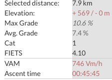
Finally climbed from Coltura to I Fanghi (just above Casera Valle Friz) with my road bike. The middle section from Mezzomonte cemetery to 1000 meters seemed easier than I remember but the ramps near the top were hard as ever.  After that the newly paved road is just glorious, and gives easy access to Piancavallo's wide, smooth descent.  This is my new favorite local climb.  It's very close to home, is difficult enough to challenge you and the area is completely wild.  Wildflowers everywhere today, lovely weather.

After the road crests at I Fanghi you approach
this hiking pass near Valle Friz 

Looking back at the road (the straight line parallel with the ridgeline)
above Valle Friz

View down valley to Croda San Tome and Dardago

View east of road descending from Casera Campo

Monte Candole

Casera Campo


Challenging climb


Thursday, July 7, 2016

Salto della Capra

Monte Grappa has more cycling routes to climb than anyplace I know.  Over the last few years I've done 5 of them  but today I finally got around to the Salto della Capra (Jump of the Goat) climb.  This is right up there with  Bocca della Forca from Possagno in difficulty.  

I warmed up on the easy climb from Semonzo and then turned onto Via San Liberale.  Branched to the right at 530 meters and began 30 switchbacks through the forest.  I was doing pretty good up to 1100 meters then all hell breaks loose.  I stood of course, then started gasping to get enough air.  Near the top I was almost ready to hop off and lie down in the road to rest awhile but I caught a glimpse of the goat weathervane.  This gave me the inspiration I needed to gasp and sputter to the top.  

After a rest I headed west past La Vedetta turnoff at 1447 meters then down into the Valletta, with herds of bell-ringing cows.  The summit of Monte Grappa was socked in so at 1500 meters I decided to head down the wider road to Semonzo.  Very nice descent. 


Wildflowers and a deep gorge

The steel goat weathervane shows no mercy

Goats-eye view of the final deadly switchbacks

Chiesetta atop La Vedetta (1445 m)

Cute baby asino walkin down the road with family


Salto della Capra difficulty


The hard part at the top


Tuesday, July 5, 2016

Rifugio Nordio-Laghi Fusine

Returned today to Ciclovia Alpe Adria to complete the Pontebba-Tarvisio section.  I drove to Valbruna, in the middle, then rode on the bikeway to Pontebba.  I then returned on SS13 (sparse traffic at 7 AM) and turned north at Ugovizza.  Here begins the climb to Rifugio Nordio, almost on the Austrian border.  You can continue on MTB up into Austria, or even road bike it if you wish (I think Jerry from Sweden crossed the ridge and went down into Gailtal region from here).  

I coasted back down to Ugovizza and then rode the ciclovia to Tarvisio.  I then took the highway toward Slovenia and turned off at Laghi Fusine.  This is one of the prettiest places in Friuli, with beautiful blue water and dense fir forest beneath Monte Mangart on Slovenian border.  Marilyn, Rocky and I went snowshoeing there one winter- stupendous alpine scenery in the backcountry.

On the return I used the ciclovia through Tarvisio, much nicer than the highway.  Tarvisio has a network of these bikeways, really extraordinary for such a small town.  I'll have to return soon and explore more of them.   


Foot bridge over Torrente Uqua


Church at Ugovizza

Ugovizza from the climb


Jof di Miezegnot


Pretty wooden house above Ugovizza


End of pavement near Austria


Julian Alps from the descent


Lago Fusine Inferiore


Lago Fusine Superiore


Peaks above Alpe di Lago forest


Thursday, June 30, 2016

Alpe Adria Ciclovia

I rode up Strada di Bottecchia from Pinzano to Gemona then continued on SS13 up to Pontebba.  Almost all the through traffic uses the autostrada so the wide smooth roadway of SS13 is great for cyclists.  Today I was looking for something else though:  the recently completed section of Ciclovia Alpe Adria from Pontebbe to Moggio.  Just before you enter Pontebba on your left is a cemetery and chapel on a hill.  Arriving there you continue following the signs (including a very steep ramp in the high teens).  Soon  you begin encountering tunnels, lit for cyclists by solar arrays near each tunnel entrance.  The construction is to very high standard: asphalt is smooth, the numerous bridges are very tight metal grid deck so smooth I never even noticed with 23mm tires.  Heading south is slightly downhill so very easy even for folks with touring bikes, MTB, families with kids on their little bikes.  The scenery is spectacular.

At Resiutta (across the river from Moggio) the bikeway ended where they are constructing the next section.  I rode SS13 down to Venzone where I noticed another new section of the path at least to Gemona (may go even further).   And I still need to do the section from Pontebba to Tarvisio.  Maybe one day I'll complete the Austrian section to Salzburg.


Mountains above Resiutta

View west toward Val Aupa

Start of ciclovia south from Pontebba

Left: Gorge of Fiume Fella
Center: SS13 highway
Right: Bike path on roadbed of old Austrian railroad to Trieste

Crossing Fiume Fella on old railroad bridge

3 tunnels in a row.  So many I lost  count

4-decker waterfall on side of gorge

Yet another of numerous cascades

Tuesday, June 28, 2016

Podbela Napoleon Bridge

This is my third attempt on this ride.  The weather was perfect when I left at 0530 and before long I reached San Daniele.  This starts a long stretch of saliscendi along the foothill towns.  At Faedis begins the long ascent to Bocchetta San Antonio.   Then you descend to the Slovenian border at Robidische, where the plummet to Torrente Natisone starts.  Along the deserted road a stone bridge suddenly appeared and I hopped off to explore.  It's a lovely area and very shady even on this sunny day.

The ascent back to San Antonio was tough but I survived.  Then the long descent to Faedis, featured in the Giro d'Italia 6 weeks ago.  Ride home was long but not unpleasant.  Perfect day for a long ride.


World War I memorial at Ragogna

View south from San Antonio

View north of Julian Alps

Napoleon Bridge over Fiume Natisone

Another angle


Climb from Faedis to San Antonio

Climb from Napoleon Bridge to San Antonio


Friday, June 24, 2016

Passo Mauria

I've been wanting to ride the Monte Rest-Passo Mauria-Passo San Osvaldo loop but never got around to it.  Today was my chance.  After Monte Rest you descend and then climb through Ampezzo to Cima Corsa.  Next pass through the long tunnel to Forni di Sotto and climb to Forni di Sopra.  Here you start the climb up past Sorgente di Tagliamento fino a Passo Mauria.  Descend to Lorenzago and then Lozzo di Cadore.  The traffic was lighter than expected here, maybe still too early in the season.  

At Pieve I climbed up through town to avoid the busy tunnels below.  Descending to Sottocastello I joined the via ciclabile and headed south.  They have really fixed up this bike route, pretty impressive.  Down the Cavalera to Perarolo and south on the deserted old route of SS51.   This is shady and less hilly which I was very glad of because I was close to bonking.   Luckily I reached a bar in Ospitale where I bought 3 more liters of cold water.  I thought it might be too much but no, I drank it all on the way home.

The bike route again follows a new route down to Longarone, where they've added a stretch through the gorge of the  Piave.  This would be a great place for a walk/ride with the family.  Soon you reach the final challenge up the switchbacks to Vajont dam and the baking-hot rocky cliffs below Casso.  San Osvaldo was very easy by comparison.  Mostly-downhill Torrente Celina felt like a cool-down ride and  soon I was home.  My neighbor Silvano had arrived from Venezia and baked me a fresh ciambella.  A perfect ending.  

Torrente Chiarzo at Lago di Tramonti

Lago di Tramonti

Torrente Tagliamento from Monte Rest

Cascate above Torrent Tagliamento 


Friday, June 17, 2016

Monte Pizzoc

Finally a break in the rain so I headed for Monte Pizzoc.  Cold air felt great during the ascent but at 1400 meters clouds rolled in and it got nippy.  Still a great ride.   Such a beautiful place.


Hole in the clouds revealing Piancansiglio

The climb from Sarone


Monday, June 13, 2016

Piancavallo-Mezzomonte Paved

Clear sunny morning so I took off for Piancavallo.  I decided I'd continue on to Casera Campo and then turn around at end of pavement.  When I got to the spot however the pavement didn't end.  It kept right on going up the formerly deep-gravel-and-rocks road, past Casera Valle Friz and all the way to the paved road coming up from Mezzomonte.  This is great news because now you can climb up from Polcenigo on a road bike then descend via Piancavallo Road.  Previously the rough descent back to Mezzomonte sucked unless you were on a MTB.   The gravel road toward Il Cansiglio remains, which is probably a good thing if it keeps the car traffic down.

Casera Campo

Casera Valle Friz 

The newly paved road between Campo and Friz

The gap where the hiking trail to Il Cansiglio passes

Heading up toward Col Palse

The turnoff for Mezzomonte