Sunday, August 28, 2011

Passo Duran North & South

Passo Duran connects Val Zoldo, Forcella Staulanza, Passo di Giau, etc with Agordo and its nearby passes.  I decided to ride it both ways, rather than concoct a lengthy loop to avoid reclimbing it.

I parked at Forno di Zoldo to get a little warmup before Dont (we had a cold front pass through last night and it's suddenly quite nipply).  I recommend warming up, because the road after Dont immediately climbs at 15% for a half kilometer.  I stood in the pedals for this, and it wasn't bad with fresh legs and lungs.  The road winds through some lovely small towns as it ascends above the spruce forest of Torrente Moiazza gorge.  After the last of these towns (1250m), you start a 4km series of steepish tornanti to the pass at 1605m.  This stretch averages 9-10%.

The pass is gorgeous, with big rocky summits towering on both sides.  There is a rifugio and steep meadows with cows.  I donned my windjacket and headed down toward Agordo.  This road widens a bit so you can build up some speed, then passes through a series of little villages as it winds down to Agordo.

Agordo is a tourism center, maybe a little too touristy this time of year.  I did find a pedalata to watch, which is fun because families on all sorts of bikes participate.

I never did thaw out from the descent, even in the full sun down in Agordo, so decided I needed to recommence climbing to generate some heat.  I headed up and soon found myself behind an older fellow (60s-70s), who was mashing maybe a 39-23 gear up the 9-10% grade.  I spun my feeble 34-29 and stayed far enough back not to disturb him.  I stopped to remove my jacket and next I saw him far ahead on a long straight stretch.  Later he had stopped on a short 13% ramp and I wobbled by.  Near the pass I stopped to shoot some pictures and he caught back up again, still pushing that fat gear.  We chatted a bit- he was from Genova, which I hear is very hilly.  I noticed his bike was a Shock Blaze and mentioned they were made near here at Colle Umberto, TV.  He had bought it in Genova and didn't know where it was from.  Anyway, he was just getting started, planning to ascend Forcella Staulanza next, then cruise back to Caprile and Agordo.  I only pray that I'm in such good shape in 10-20 years.

Rode the steep twisty downhill to Dont, then down to Forno di Zoldo, and drove home.  I'll be back- too pretty to stay away!


Lago di Vajont nebbia at 6 AM on the drive to Longarone 

Monte Moiazza (2868m) above Passo Duran

Pale di San Martino (2812 m) from below Duran

Dolomite columns of Monte Agner (2872m) from below Passo Duran

Monte San Sebastiano (2420m) left, Monte Tamer (2547m) right

Close up of the cathedral facade of San Sebastiano

Climb from Dont left, climb from Agordo right

Dont to Passo Duran

Agordo to Passo Duran


Friday, August 26, 2011

Passo di Fedaia

A wonderful climb to Passo di Fedaia (2057m), ascending along Torrente Pettorina, up grassy slopes and onto the shoulders of Monte Marmolada.

I started in Caprile (998m), though leaving from Alleghe might give a better warmup.  The road climbs  up through several picturesque villages with flower-bedecked wooden balconies.  The last town, Sottoguda (1250m) offers you a choice of continuing on the main road, or entering a narrow chasm along Torrente Pettorina called Serrai di Sottoguda.  This is a fantastic, quiet place, immersed in shadow and the sound of tumbling water.  No cars allowed, and I was the only biker (bikes allowed to ascend only).  It's quite steep toward the end, grappling up the gorge to Malga Ciapela (1450m).

Here you rejoin the main road, which steepens into a long straightish ramp climbing 400 meters in 3 and a quarter kilometers (over 11% median gradient).  This section is called Capanna Bill, and is famous for high speed descents (over 100kph).  A girl in a tank top came flying down this, and I was impressed that the wind chill didn't bother her- an hour or so later when it was warmer I descended with zipped-up jersey and felt cold.

After this the switchbacks begin, including the steepest sections of 17-18%.  All told the 6 kilometers from Malga Ciapela to the pass average well over 10%.  They're completely exposed to the sun, so get an early start if climbing in summer.

The top of the pass has wonderful views of Monte Marmolada (3342m) directly above, with the last glacier in the Dolomiti, whose runoff is collected in a lovely blue lake.  It's a fascinating area, and sufficiently large that even the August touristic hordes didn't spoil the place.

I headed down the tornanti and stopped to photograph a flock of sheep coming up the pass.  I felt like I was flying down Capanna Bill but reviewing the data later, was actually going a little slower than descending Piancavallo.  This time I bypassed Serrai di Sottoguda and went instead through the short tunnel and high bridge over the gorge.  Later I stopped and took some pictures of Torrente Pettorina descending through the forest and meadows.  There's a wonderful hiking/biking path along here that runs all the way from Alleghe to Sottoguda.

I'll definitely be returning here again someday.  Lovely place!


The tall, narrow gorge of Serrai di Sottoguda

Monte Sassolungo (3181m) to the west 

Dolomite dome on Marmolada

Marmolada glacier amid peaks

Glacier runoff in gorgeous blue-green lake

Dolomite tower on ridge to the north

Monte Padon (2510m) to the northwest

Marmolada rock formations above lake


Close up of glacier-carved teeth on Marmolada

Peak on Marmolada facing east

Close up of the peak

Another of Marmolada's massive formations

Flock of sheep ascending Passo di Fedaia

Shepherdess getting mama goat started milking for thirsty baby goat 

Asini enjoying their friends, the sheep and goats

Torrente Pettorina below Serrai di Sottguda

The view back toward Passo di Fedaia from Bosco Verde


GPS track of ride


From start through Serrai di Sottoguda to Malga Ciapela


The upper half above Malga Ciapela


Wednesday, August 24, 2011

Passo San Pellegrino - Passo Valles

Passo San Pellegrino is on the western border of Belluno province and Trentino Alto Adige.  It's a longish pass, starting at Cencenighe Agordino (774m) and climbing 18 km to San Pellegrino at 1918m.

At the start there is a long tunnel "delle Anime," which is narrow (given the trucks and buses that traverse it), poorly lit, and runs steeply upward for 1140m.  So I opted to follow the advice of the Ediciclo guide and bypass the tunnel using the old road along the river, which has a shorter, unlit tunnel of its own.  At first there were lunettes allowing natural light in, but these stopped after awhile, and a curve in the tunnel behind left me completely in the dark.  I stopped for a moment so my eyes could adjust, and then I could make out a faint glow far ahead.  I rode slowly toward it, and as the tunnel continued to turn, I eventually could see the opening at the far end.  I need to get a tiny headlight for these occasions.

It's a nice climb up the valley through the little towns of Canale d'Agordo, Falcade, and Falcade Alto.  After these the road heads into dense spruce forest with a series of short steep switchbacks, increasingly more difficult until you hit a healthy stretch of 18%.  After that the gradient mellows to 8-10% until the passo.

The passo is a lovely meadow area , though there are numerous ski lift operations and tourist places along the road.  I found a little side road marked Rifugio Cima Uomo and rode into the pretty meadows a bit- very nice once you get away from the main road.

Returning to the main road, I coasted down the hill until 1400 meters, and then on an impulse turned uphill toward Passo Valles.  I had no idea how far away this was nor how high, but thought I'd climb till I was tired.  The pass turned out to be about 7 km away, and 2032 meters high.  The meadows here were even more spectacular, stretching for miles.

Now I was tired and coasted back down the hill to Cencenighe Agordino.  It was much warmer when I arrived down there around noon (in the high 30's).  These are wonderful climbs in great scenery- try them if you're in the area.

Note: installed a new Michelin Lithion 2 tire on the back wheel yesterday before the ride.  The previous Krylion (installed January 2011) was worn down to the threads almost all the way round the circumference.  Decathlon was out of Krylions (which rode well and resisted punctures), but had Lithion and Vittoria (can't remember the model but they had red tread).  Will see how long these last.

West from Passo San Pellegrino toward Moena

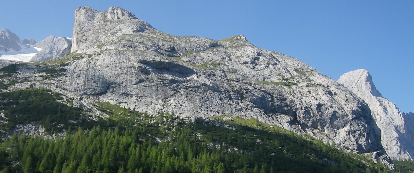
Mountain ridge to north of Passo San Pellegrino

Wildflowers along the descent

Close up of wildflowers

The meadows to east of Passo Valles

Rocky peak above the meadows

The thinning forest transitions to grassland

View to southeast from Passo Valles

Falcade and Falcade Alto from the Passo Valles climb

Falcade close up

GPS track of climbs

Altimetria Passo San Pellegrino

Altimetria Passo Valles


Monday, August 22, 2011

Monte Zovo

Monte Zovo (1943m) is in northern Belluno province near Austria, not far from il Sorgente del Piave.  I thought I would knock out a couple of climbs while I was there- surely one wouldn't be enough.

After driving to San Stefano di Cadore I rode the bike east toward San Pietro.  I turned left off the main road and followed the steep (8.6% average) grade to Costalta for 4.3km.  Costalta is a very pretty hillside town with lovely wooden homes, balconies covered with flowers.  From here a flattish road clings to the side of a gorgeous steep valley, to the site of an old sawmill, and now the real climb begins.  

The next 2 kilometers you gain 283 meters, averaging 14.2%.  I was hanging in there, gasping and blubbering until a baita just below Capella Santa Anna, when the rear wheel lost traction on loose pebbles and I quickly got my foot down to avoid falling.  There was no re-starting here on 20% gradient, and I was knackered anyway.  I rested a moment then put on my cleat covers and walked about 500 meters.  I caught my breath by the time I reached the junction of the road from Valle, and rode the final few hundred meters to the rifugio.  The road becomes dirt here and is part of a mountain biking, horse-riding park in Val Visdende.  This makes me want to fix up the old mountain bike more than ever.

After returning to Costalta I followed a great road that traverses the mountain side all the way around to Costa, the Strada Panoramica del Comelico, immersed in tall spruce trees, with fantastic views of the valley and surrounding peaks.   At Costalissoio I unwittingly followed Strada Provenciale 30 Dir instead of continuing on the more-level panoramica to Costa.  So, after a fun descent to Campitello (976m), I began the ascent to Costa.

This climb rises through San Nicolo di Comelico to Costa at 1346m, averaging 8.8% gradient.  I rode around the pretty town of Costa awhile, looking for the turn off for Monte Zovo- turns out it was at the last tornante before town (unmarked).  

The Monte Zovo road has recently been repaved and the surface is perfect, though watch out for the drainage grates.  It is open to the blazing sun, and steep, gaining 450 meters in about 4km.  I stopped to walk 3 times when the gradient was too steep/I was too weak.  Awesome views from end of pavement at 1837m, and the summit (1943m) after a km of strada sterrata is said to be even better.   

Easy roll down to San Stefano and drive home.  Must return and ride this again!


San Pietro from Costalto

Costalto (1324m)

Danta (1398m) across Val Padola from Costalissoio 

Candide (1212m) from Costa (1346m)

Falling water along Strada Panoramica del Comelico

Wildflowers along Strada Panoramica del Comelico


Close up of wildflowers

They got the tortuous right

Left Rifugio Forcella Zovo (1600m), right Monte Zovo (1837m)
Rifugui Forcella Zovo, from www.salite.ch


Monte Zovo, from www.salite.ch


Steepness of Rifugio Forcella Zovo climb


Close up of Rifugio Forcella Zovo

Close up Monte Zovo