This morning got off to an inauspicious start. As I started to take my bike to the car, I noticed the rear tire was flat- odd because I'd checked everything last night. I changed the tube and drove up to Amaro, near Tolmezzo. Then when I got ready to ride I found I'd forgotten my cell phone- not good if you have an accident or breakdown. I pressed on. My original plan was to ride the old road along the foot of the mountain to Tolmezzo, but alas the ride was closed for frani (landslides) after 2 km. So I returned to Amaro and headed up the busy strada statale. It's nice and wide and has a wide shoulder, so it wasn't so bad. Anyway, they say bad things happen in 3's so maybe it's true as everything else went well.
Just before Tolmezzo I turned and headed for Illegio. This is a beautiful warm-up- very gentle gradient, wide, smooth pavement, gorgeous scenery. I passed a large, popular rock-climbing area, deserted this early morning. Further up the road passes through a lovely forested gap, then enters the open meadows approaching Illegio. Really pretty place. After the town the road heads into the forest and gets a bit steeper and narrower, with rougher pavement. Lots of stream-crossings (some on bridges, some guadi or fords). The steepness increase, with short switchbacks grappling up the little gorge. At 860m the road was completely blocked by a huge truck and a crane placing refrigerator-sized blocks of stone or concrete along the road edge. No way around, so I turned back. I'll return to try this again- the end of pavement is at Pra di Lunge (925m) about one kilometer up the road.
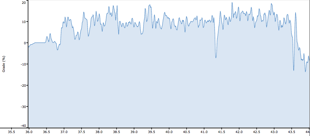
The descent was great fun on the smooth curves. Then down SS-52 to Amaro, and the real climb begins. I turned left, passed the church/cemetery, and shortly afterward the gradient steepens. The road is basically 20 tornanti right up the side of a rocky mountain, climbing 650 meters in 6km. Numerous sections above 14% (around 18% at times). There are some nice trees providing shade, but most of it is exposed to the south. Luckily we are having a cool spell, so not bad at all this morning. Most of the steepest parts are paved in concrete with grooves machined into surface for traction (drainage?). Not bad at all. And the asphalted sections are mostly smooth and in good condition- it's a surprisingly well-maintained road for so little traffic. I came across one mountain biker descending- otherwise it was deserted.
The highpoint is a narrow notch between 2 mountains called Cristo di Forca (1058m). The pavement continues downhill from here then dead-ends eventually (see Jerry's description at www.cycloclimbing.com ). I rolled down to a gravel parking spot where people start their hikes up Monte Amariana (1905m). From here I snapped a few pictures, then headed back. I descended fast on the straights but took it easy through the tornanti.
Both these climbs are quite fun- highly recommended!
 |
| Rio Frondizon above Illegio |
 |
| Looking southwest across meadows near Illegio |
 |
| The meadows looking west |
 |
| Rio Maggiore tumbling down from Monte Amariana |
 |
| Southeast toward Amaro, Torrente Fella (from left) and Torrente Tagliamento |
 |
| From Cristo di Forca looking southwest at Cavazzo Carnico and Sella Chianzutan |
 |
| Monte Amariana above Cristo di Forca |
 |
| Map of the ride |
 |
| The climb toward Pra di Lunge |
 |
| Climb from Amaro to Cristo di Forca |
 |
| The 2 climbs- note the >10% average gradient on Cristo di Forca ascent |
 |
| Note numerous 14-18% stretches on Cristo di Forca climb |


No comments:
Post a Comment
Note: Only a member of this blog may post a comment.