Saturday, January 1, 2011

Val Cosa - Val Chiarzó

New Years Day 2011 was cold, clear and sunny.  I set out across the plain to Travesio, arriving in one hour (27.7 km).   From here the road heads up Val Cosa, a winding valley through the foothills.  After a few kilometers,  a small dam (with waterfall pouring over the top from all the rain) holds back Lago del Tul, while the road follows Rio Crevid to the right.  

At 220 meters the climb proper begins, climbing 500 meters in 8 kilometers.  The first section, through Clauzetto at 560 meters, is a lovely switchbacked, well-paved road.  Then the road steepens and becomes a rough meandering mountain lane through the tall beech forest to Cristo at 723 meters, then down and up to Orton.  Lots of rolling pasture here with views all around.   

Now I headed down the bumpy crooked lane to Gerchi (535 m).  I got a bit chilled on this section as the road is too rough to pedal downhill, so no exertion to keep warm.  Then the road immediately turns uphill, through a jumble of curvy karst stone formations.  Never quite warmed up on the climb up to Piani di Clauzetto at 675 m.  Then another longish, rough descent with much frost and ice to Campone at 425 m, further chilling me.   

The long ride down Val Chiarzó was beautiful, with frost-covered bare trees everywhere, but was colder than ever, as the sun never reaches this gorge in winter.  I was a block of ice when I arrived at the main road along Lago Tramonti, but now with smooth, ice-free pavement, I could try to warm up through exertion.  

I pedaled hard as possible down to Meduno, across the river to Cavasso Nuovo and Fanna, then around Maniago and over the Cellina  to Montereale.  I made it home somewhat thawed, but not really warm.  Took the pups for a walk, ate some fruit and some salmon, but never really warmed up till I took a hot soak.  That did the trick. 

I'll try to wear my extreme weather gear next time when heading over-600 meters in winter.  I have some thick Gecko Gear pants, neoprene overboots and third-layer overgloves I can try.  I usually save those for windy cold days on the plains but maybe they'll work in the foothills as well. 

Torrente Cosa

Gerchi, from Orton

Torrente Chiarzó frosty trees

Thursday, December 30, 2010

Castello di Cordignano - Castello di Caneva

Lightly overcast and cold when I left, but after Budoia, the skies turned blue and sunny.  Lots of cyclists out today, despite the frigid weather.  I rode along Via Pedemontane Occidentale to Sarmede, then attacked the short, steep climb up to Rugolo.  I made it up the 12-14% switchbacks seated, then a half kilometer of 10% made me stand to continue.  At the church in Rugolo the road levels out very briefly, then comes the turn off for Rugolet, another 12-14% climb, though mercifully brief.  I've ridden through Rugolet in the opposite direction but this is the first time headed east.  Nice mountainside rolling road, though short.  It passes through some pretty woods, in contrast to the rolling prosecco vineyards covering most of the area.

Now you arrive at Castello di Cordignano, the ruin of an 11th century castle.  The defenders had a great view of any approaching armies.  Normally I arrive here in the middle of a hard climb from the plain, and don't really clearly see the place, but today I was coming downhill so I could stop and check it out.

The descent continues to Villa di Villa then Caneva.  Here starts another little climb up to Castello di Caneva, a better condition ruin.  This one also was started in 11th century.  It has a lovely old church with stain glass windows, though I haven't been inside.

The climb spirals around the little promontory and eventually arrives at a crossroad for Il Cansiglio and Sarone.  I headed down the long grade through Sarone, a 150 meter plummet down to the lowlands where Fiume Livenza emerges from the base of the mountain, at the spring La Santissima.

From here a 25km rolling climb home on Via Pedemontane Occidentale.  Several young fellows zipped by like I was standing still.  Now I'm very tired.

Castello di Cordignano fortification

Castello di Caneva 

Rolling prosecco vineyards

Looking across the vineyards toward campanile di Caneva


The grade from Sarmede to Rugolo, castello di Cordignano, Caneva, castello di Caneva, Sarone

Monday, December 27, 2010

Vivaro-Budoia

Finally the rain stops and blue skies return!  On the flip side, the temp's around 0℃.  Much new snow on the mountains, so I headed for the plains.  I glided down the long, slight downhill from Vajont to Vivaro.  Then west to the bridge over the Magredi del Cellina.  I stopped to take some pictures of the mountains, and a paceline of four riders slowed and everyone asked if I needed help "Hai bisogna?  Tutto apposto?"  Very nice feeling having others watch out for you here.

Then through San Foca, San Quirino, Roveredo, and turn north toward Budoia.  Easy 4-5% grade from the train tracks up to the main road in Budoia.  Then rolling hills westward past Aviano, Marsure, and home.  Felt great while riding, but quite cold as soon as I got off the bike.

Monte Cavallo, Pala Fontana. Pala d'Altei (left to right)

 East Ridge of Valcellina, Monte Raut (left to right)

Tuesday, December 21, 2010

2010 Recap


2010 is coming to an end, so before I flip the calendar page I wanted to say what a wonderful year it's been. The mild weather and good fortune surpassed all expectations.

I started riding again a couple of years ago after a long period of dormancy and illness. I only wanted to recover some strength and fitness, then maybe someday ride around the foothills where we live. I never dreamed I could ever climb the high passes of Carnia and Dolomiti Bellunese. To me it still feels miraculous- each climb is a gift I never expected to experience again.

Several rides stand out for both the challenge of the climb and beauty of the environment: Sorgente del Piave, Sella di Razzo and Monte Crostis. If I had to chose, the most fascinating was Monte San Simeone. It was a mystery: the only report I'd found beforehand was from mountain bikers, so I wasn't sure it was paved. But what a pleasant surprise- it was a well-designed road with dozens of switchbacks, many tunnels and a constant grade. There were almost no cars and the views were spectacular. Best of all were the hundreds of butterflies, and the glorious wildflowers in the alpine meadows at the top.

Here's hoping 2011 is as good a year or better- Happy New Year!


Sunday, December 12, 2010

Mezzomonte 3

Sunny cold morning.   Enjoyed seeing many groups of riders coming up from the plains on Via Pedemontane Occidentale.  Descended to Gorgazzo at 50 meters above sea level, then rode up to the turn off for Coltura.  The road gets very steep (16%) till the top of the town, and then starts a climb up 11 tornanti to Mezzomonte at 496 meters.  I stood on everything over 12%.  Lungs felt great (they like cold dry air apparently).  I rode slowly on the way down, looking for a spot to take a picture, but the trees blocked all the great shots of the tornanti etc.

Normally I warm back up on the 300 meter climb home but not today- I was cold when I got home.  But it was nice walking the dogs in the afternoon with the sun shining- felt a little warmer.

Garmin hasn't saved the last two rides.  I tried clearing out the memory.  If the next ride is dumped I'll try replacing the battery.

Friday, December 10, 2010

Val d'Artugna 3

Another fortnight of pouring rain, and finally a day of clear skies.  I headed down Via Pedemontana Occidentale, past Aviano at 129 meters, up to Budoia and Dardago, then turned up toward Val d'Artugna .  It was cold but the exertion of climbing heated me up quickly.  I stayed seated all the way up the 10-11% slope, past Il Rifugio and La Chalet, accompanied by the roar of rain-choked Torrente Artugna far below in the gorge.   I passed a couple of older gentlemen walking a little black and white dog.  One of them warned me "Guarda su il inizio, cora" but I wasn't worried- I've ridden this many times before.

At 450 meters I rode carefully in the gutter around the closed barrier, and continued up the narrower mountain lane to end of pavement at 570 meters.  Nice view down the gorge toward Budoia and the plain.  Fun descent- long straight stretch glide in aerodynamic tuck.

Tuesday, November 30, 2010

Toppo - Usago - San Foca

After a couple of rainy days, today was merely overcast and cold.  So I jumped on the bike and headed for the plains.

After a fast spin through Fanna and Cavasso Nuovo,  I crossed Fiume Meduna, emerald green and full of rain runoff, then climbed toward Meduno.  Before reaching town I turned right for Toppo.  This is a pretty road which runs through pastures between Monte Ciuarlec and colline di Sequals.  The overcast skies yielded to clear blue and sunny, and even the cold felt comfortable after hard pedaling.  At Usago, I passed through a gap in the colline di Sequals and entered a leafless wintery woodland on the way to Sequals.

After recrossing the Meduna I headed through open pastureland to Arba, and then turned south to Tesis.  Shortly after, I turned on the new road to Vivaro, across the  Magredi di Cellina to San Foca.  Here I headed north on the treelined backroad to San Leonardo.  Pssst my front tire quickly flatted.  Had a rash of these lately, both front and back.  Time to retire the front tire and move the back tire forward.

North of San Leonardo the clear skies went gray and sunless again, but no problem- I was almost home.

Monte Raut

Mountains along west side of Val Meduna

Monte Cavallo

Col Nudo in the distance, Monte Raut on right

Julian Alps along Slovene border

Julian Alps stretching southeast

Saturday, November 27, 2010

Monte Ragogna da San Rocco

Yesterday the previsione called for 20 cm of snow at 300 meters.  Luckily, the snow stayed above 400-500 meters, while at 300 meters we only got a little slush.

So today I stayed low to avoid the snow.  The temps were about 10 degrees cooler than yesterday, but it was sunny without much wind- very fine weather.  I headed over to Pinzano, crossed the Tagliamento, and climbed up to San Rocco.  Here starts the short but steep climb up Monte Ragogna.  It is an unusual mountain- it sits alone on the east bank of the Tagliamento, like a miniature Rock of Gibraltar.  In the build up to World War I, underground munitions warehouses, artillery emplacements, and fortifications were burrowed within the rocky massif.   There are numerous signs explaining historic sites throughout the area.

To the climb: after a gentle rise along the bank of the Tagliamento passing the restored castello di Ragogna, the road heads upward steeply.  I stood on everything above 10%, including a stretch of over a kilometer.  Lungs felt great- maybe the cold dry air is helping?  The road is covered by fir trees, with brief glimpses through the trees of the junction of Arzeno and Tagliamento rivers, the foothills of Castelnuovo, Monte Prat and Monte Cuar to the northwest, and San Daniele to the east.  The road was pretty clear up to 400 meters, though snow caught in the fir tree limbs was dropping snowballs on me now and then.  Higher up the snow covered the road in stretches, though it was not deep enough to be impassable.

After the high point (495 meters), the sheer descent to Muris begins.  I held the brakes through the snow on the upper part, and as the road cleared below, I got up some speed on the straights before the inevitable sharp bends.  In this section there were great views to the north of Gemona and Monte Chiampon.   From Muris I rode back to San Rocco and headed home.  Felt great cruising on the long flat from Lestans, Sequals, Arba, Campagna, and Montereale to Giais.

The Tagliamento full of rain runoff

West toward Pinzano

Castelnuovo, note our rented house from 1994-1996

To the north, Monte Chiampon above Gemona


Gradient of Monte Ragogna

Thursday, November 25, 2010

Col Alto da Pedemonte 2

I've ridden this once or twice before in Summer, but never this late in the year.  But no rain or snow in the forecast, so why not?

After a brief warm up on the pianura, I headed up the road to Piancavallo.  It was cool out and partly cloudy, but the heat of exertion kept me toasty.  On all stretches above 10% I had to stand, as my back and glutes were still wore out from Il Cansiglio.  I was having trouble breathing, as before, but I just gasped and panted and anything else I could do to keep going- never had to stop to catch my breath.

At 1000 meters I took a few pictures while I still had sunlight, as black clouds were gathering on the mountain.  Then at Caldastia, I turned off the main road and onto the narrow mountain lane for Col Alto.  At first it is less steep, so you can catch up on your oxygen debt.  Then it too starts grappling at 12-14%.  The sun was gone, and with the altitude, temps were below 0℃.  Then the road had patches of snow and ice, so I had to remain seated to maintain traction.  That was challenging.  The high point at 1379 meters marks the end of beautiful faggio forest and the beginning of a fir tree-covered neighborhood of  ski vacation homes.  I descended gingerly on the snowy road to Piancavallo.  The ski slopes were covered with snow, but I guess not deep enough for skiers yet.

Now the big descent starts, and right on cue it started snowing.  I rode as fast as possible on the straights to evade the snow, but had to brake hard before every hairpin.  My hands were frozen from the windchill, but managed to brake adequately.  Around 800 meters the snow changed to rain, but I still was hurrying to escape.  Things got better around 300 meters and soon I reached the bottom.  I completed the 200 meter climb to home in a semi-frozen state, only really warming up on the steep section between Marsure and Giais.
Later we had a little Thanksgiving Dinner- good warm food!

Looking back down the tornanti, with Aviano and Fiume Cellina in background

Centro Riferimento Oncologico, reminding me I have an MRI appointment next week

This is the only glimpse of snowy Monte Cavallo I could catch among the storm clouds


Tuesday, November 23, 2010

Il Cansiglio da Villa di Villa 2

Another 2 weeks of rain and finally a chance to ride- still overcast, but at least no rain.  I thought I'd climb from Villa di Villa to Il Cansiglio, then continue to Monte Pizzoc (1500m).

After cruising down Via Pedemontane to Villa di Villa, the climb began.  I stopped to take off my wind jacket, which was too hot for the humid 40s temps.  This is a very remote climb- no towns, few houses and hardly any traffic.  I did see a couple of hikers and one descending mountain biker.  It starts off with some steep 11-14% bits, then settles into a long steady climb through dense faggio forest at 8-10%.

I had to stop 4 or 5 times to catch my breath.  This is unusual on a climb of this moderate difficulty- it's not easy (1037m altitude gain in 15 km, at average grade of 6.8%), but normally I can do this without stopping and without feeling beat.  It's like I can't get enough air in my lungs.  Yesterday I had gone for a spirametry test and it indicated I don't have asthma, but something else is wrong.  Hopefully my doc will figure it out.

Anyway because of this and the fog/clouds I decided not to do Monte Pizzoc (an additional 438m elevation gain).  Instead I donned my wind jacket at Passo La Crosetta (1118m) and swooped down the hill to Sarone.  There were some stretches of dense fog, and the road was damp with some fallen rocks and lots of wet leaves in the corners so didn't descend as fast as in summer.

I thawed out awhile on the flattish road to Polcenigo, then climbed the additional 300m home,  quite beaten.

Gradient

Friday, November 12, 2010

San Martino di Chies d'Alpago

It's rained for two weeks straight.   Today it was foggy and drizzly here, but the  forecast called for clear skies in Alpago.

I drove to Vittorio Veneto (overcast) and warmed up on the climb to Lago Santa Croce.   Sure enough coming over the pass, the skies and lake were bright blue.  I rode along the east bank of the lake to Puos.  Up through Cornei, and then started the climb toward  Chies d'Alpago.  At the turn for Chies, I went straight, continuing up the grade to Lamosano at 700 meters.  It's a nice wide smooth road with 8% grades and many switchbacks.

The views from Lamosano are wonderful.  Alpago is a bowl-shaped valley, surrounded by snow-capped mountains, with reflections on Lago Santa Croce far below.  The valley is covered in steep meadows full of sheep, as well as groves of faggio and fir trees.   In every direction picturesque villages cling to the sides of steep slopes, in each a lovely church with Austrian-style steeple.  Really gorgeous.

After Lamosano I continued upward steeply on 10-12% switchbacks to San Martino at 860 meters.  Did a lot of standing on this section.  After passing through the village I saw a sign pointing the way to my objective, La Carota.  It's a rifugio on the road up to Monte Dolada, the climb that kicked my butt back in July.  On Google Maps I'd seen a several- kilometer-long, cliff-hugging road connecting San Martino with La Carota.  I didn't know if it was paved or dirt, but I wanted to find out.

The narrow mountain road comes out of San Martino with steep switchbacks heading up slope.  I stood and was surviving until the 24% ramp began.  I struggled best I could, but it went on and on and wouldn't end.  Finally I could go no further and stopped to recover.  After a few minutes I stopped hyperventilating and tried to figure out how to restart on this slope- the road was too narrow to go cross-slope long enough to clip in and turn upward.  So I put on my cleat covers and walked a couple of hundred meters up to a semi-level spot.

From here the road passes through a forest of tall fir trees.  It alternates between level stretches and short steep bits.  At one point the road was completely covered with rocks which the heavy rains had carried down from above.  I stood and crossed it, then greeted some folks who were loading their trailer and tractor with firewood.  Shortly after I could feel the rear valve stem thumping- the rocks had flatted my tire.  So I changed the tube and started again.  A young lady walking a cute whiskery black dog walked by, and then the pavement ended  at 1020 meters.  Maybe in dry summer this would be possible on a road bike as the slope wasn't bad, but I wasn't  going to try it after the flat.  Plus I had gotten a late start, and didn't want to ride down to Vittorio Veneto in the dark.

The ride down was fun, and allowed me to catch my breath.   Once I reached Puos, I bored down and tried to ride as fast as possible to beat the darkness.  I reached the car around 1700, which is just after sunset this time of year.

Good ride, and I saw several other variations to try.  From San Martino there's a road to Col Martino, 1000 meters.  From Lamosano another road goes through Funes to Caserne Crosetta at 1156m, and another connects to Irrighe and Tamera, then Casera Cruden at 1093m.


Friday, October 29, 2010

Monte Rest out & back

Today's the last day of sunshine for awhile, so I headed up Passo Monte Rest.  I was a little worried the pass might be snowed-over because it's over 1000 meters, but I figured I could just turn around if the road was closed.

I headed to Meduno, then Tramonti di Sopra where the climb begins.  It climbs gradually at first, until the Ponte di Torrente Viellia at 492m.  From here to the top you traverse 26 switchbacks, gaining 560 meters in 8 km.  The surroundings are beautiful- beech tree forest with orange and yellow leaves dappled with sunlight, mixed with dark green conifers.  All the rain has the streams running like crazy, with gorgeous waterfalls where the switchbacks repeatedly cross Torrente Viellia.  The sound of birdsong and falling water accompany you all the way up the climb.

After the road crosses this torrente for the last time, through a gap in the trees there's an awesome panorama of the valley and surrounding mountains, with the twisty road you've climbed visible far far below.  The cliffs of Monte Rest rise hundreds of meters vertically above you.  Around 900m snow appears on the road sides, though much has melted from the southern exposure's  bright sun.  Above 1000m the snow covers everything- just before the top you enter the shade of an adjacent peak, which has prevented the snow from melting.  It weighs down the boughs of tall conifers, with occasional loud crashes of a limb's snow-load impacting the ground far below. 

After donning my wind jacket I headed back down.  I slowed to a snail's pace at the end of each tornante because of ice and wet leaves, stopping several times to enjoy the music of waterfalls.  On reaching the bottom I rode home as rapidly as possible to check on the dogs. 


Thursday, October 28, 2010

Pala Barzana - Orton

After a week of rain I was eager to hit the road on this sunny morning.  Unfortunately while it was raining down here, it was snowing in the mountains,  and I read it was accumulating down as low as 800 meters.  So I decided to stay low, and do a series of medium/small climbs rather than one tall peak.

It was quite chilly out, but nice and warm inside the 4 km tunnel to Barcis.  I headed up the hill toward Pala Barzana.  They've patched up the worst parts of the road, including a one-foot vertical slump above Bosplans- that used to be a pain.  Luckily there was no snow all the way to 855 meters.  The views of snowy Monte Raut directly above me, and the mountain range above the west escarpment of Val Cellina were glorious.

I descended the curvy road toward Poffabro more slowly than usual- lots of damp leaves in the curves.  The streams and torrenti were churning with white water- quite noisy.

After Poffabro I descended down Val Muié to Navarrons, and then crossed the Meduna.  Saw 3 eagles along this road, a large one only 20 meters or so away. After Lago di Tramonti I turned right on the road toward Campone.  This road climbs through the lovely gorge of Torrente Chiarzò for maybe 10km- very peaceful place.  After a bit of climbing you reach Piani di Clauzetto at 675 meters.

Then a short fast descent to Pradis di Sotto and the climb to Orton begins- tornanti through dense beech tree forest, engulfed in orange leaves backlit by brilliant sunlight.  At Orton are open meadows with spectacular views of snowy mountains to the north and west.  Directly above stands Monte Pala, covered with fir trees.  The actual high point on this climb is at Cristo- 723 meters.

From there a steep descent to Clauzetto.  The road through town was closed for repair, so I headed down the fast sweeping tornanti to Vito d'Asio.  Shortly after I turned on the small road to Celante.  This is a very narrow road, rough, covered with leaves, branches etc.  But it's heavily forested, and not too steep.  Riding through here I remembered Marilyn and I taking Sunday afternoon walks with our terrier Rocky on these roads when we lived in Castelnuovo ('94-'96).  Good times.

This little lane eventually joined the curvy main road below Clauzetto to Travesio.  Torrente Cosa was roaring with rain runoff.

Now on the flats I bore down and rode as fast as I could all the way home- the pups were waiting for my return!

This is a great ride, with possible variations.  You could add Meduno- Monte Valinis-Campone in the middle, or Monte Prat at the end.

Elevation

Pala Barzana to Lago di Tramonti


Piani di Clauzetto-Orton


Thursday, October 21, 2010

Nevegal-Monte Faverghera da Belluno

I was delighted to read on Italian Cycling Journal that the 2011 Giro d'Italia will include a climbing time trial from Belluno to Nevegal.  Can't wait to see the racers speeding up this steep grade against the clock.  To celebrate the news, I decided to ride the course.

Last month I rode from Lago Santa Croce to Nevegal-Monte Faverghera.  Today I followed the same warm up from Vittorio Veneto up over Sella Fadalto to Lago Santa Croce.  But this time I continued through Ponte nelle Alpi to Belluno.

From here there is a nice climb up to Castion.  Shortly afterward the road shoots skyward, gaining 550 meters in 5.5km (about 10%), with stretches reaching 15%.  The terrain is beautiful dense forest, which looked great in Autumn gold.

After the steep bit, you reach grassy meadows and then Nevegal (1000m), a ski center.  The time trial in the Giro won't include it (as far as we know) but the road continues switchbacking through the forest to 1400 meters.  Beautiful views of the surrounding Dolomiti peaks on this crystal clear day.

Descended rapidly (and coldly) to Nevegal, then headed down the route I rode last month to Vich and Lago Santa Croce.  It has some awesome long steep straight stretches which are a blast.  Just keep your eyes peeled because the hairpins arrive very suddenly!

After skirting the flat lakeside, I climbed briefly to Sella Fadalto, then another fast curvy descent to Vittorio Veneto.  Awesome ride!  Should be a great Giro stage.


The gradient from Belluno to Monte Faverghera


Tuesday, October 19, 2010

Foothilly ride


Sun popped out today after a few days of rain.  The mountains out back are capped with snow.  So I decided I should stay at low elevation to avoid the snow and ice.

Headed down Via Pedemontane to Sarone, then turned and climbed up to Castello di Caneva.

After descending to Caneva, I headed up past Castello di Cordignano at Villa di Villa.  Very steep little road up over the hill to Rugolo (15% stretches).  I continued along this hillside road through Montaner to Fregona.

I descended steeply from Fregona to Vittorio Veneto, then found the start of the forested climb to San Lorenzo.  Beautiful fall foliage!  After the summit I turned toward Tarzo, on the hillside above the valley stretching from Vittorio Veneto to Valdobbiadene.

I then crossed over the ridge above Conegliano and descended to Vittorio Veneto.  Lovely views from that ridge.

I rode fast along the flat road to Fiaschetta, and then climbed the rolling hills up to 300 meter altitude and home.  Total 105km and 1367 meters of climbing.

The hilly profile


Friday, October 15, 2010

Passo San Boldo da Tovena

I've been sick with a cold or flu all week, but now my fever broke, it's beautiful out and it's time to ride.

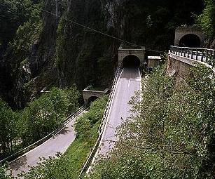
This climb starts off the road from Vittorio Veneto to Valdobbiadine.  It climbs gently through a beautiful little green valley for a few kilometers, then starts the first of 18 tornanti up the forested slope.  Then at tornanti 6 you reach a near vertical cliff wall at the head of the valley.  The next 5 tornanti are directly on the cliff face, with the u-turn at the end of each one inside a u-shaped tunnel.  It's a remarkable piece of engineering, and they manage to keep the gradient down in the 10-12% range all the way up.  Marilyn has my camera in the States, but you can see a picture of the scala here:
http://www.magicoveneto.it/Trevisan/CisonValmarino/Strada-Passo-San-Boldo_F01.jpg

After the pass (706 meters) I descended on the easy side to Trichiana.  Here you join the main road from Belluno to Feltre- a bit too busy for my taste.  At a traffic jam by Belluno I said to heck with it and headed up the road toward Nevegal.  I was hoping some of these little country roads would connect to the descent to Lago Santa Croce.  I climbed up past Castion, Caleipo and Sossai to 570 meters but the road eventually turned to dirt and got too steep, so I turned around.  By now the traffic jam was gone so I continued down the main road.  I skirted Lago Santa Croce, climbed up to 500 meters at Passo Fadalto, and descended rapidly to Vittorio Veneto.

Great ride- I'll try it in the opposite direction next time.