Showing posts with label Rifugio Bornass. Show all posts

Saturday, February 7, 2015

Bornass Test Climb

I changed my click-clacking bottom bracket bearings and needed to do a climbing ops check.  So I rode down to Costa, up by Madonna delle Monte to Rifugio Bornass.  Beautiful clear day with no wind and just the right chill.  The bottom bracket is fixed!  Success!  

Made it up to 800 meters before the snowy road made me walk 

This trail connects to the area where I was snowshoeing the other day.

Snow-covered slopes above- will have to MTB up there this Spring


Note: the non-driveside Ultra-torque bearing does not contact the crank arm rubber seal as Campy states.  The first time I installed the bearing I continued tapping until it contacted the rubber seal, but the taper of the axle made the bearing very hard to turn.   I took a flat 10 km test ride and didn't detect increased resistance but the added force needed to turn the crank might make a difference on a very long ride or steep climb.  I pulled the crank arm back off and removed the bearing with Park puller.  The bearing felt fine after removal so I reinstalled it.  This time I didn't tap it down all they way till touching the rubber seal: left about a 1/16" gap.  The bearing turns smoothly and easily.  On my climb today it worked great.  So mind the gap!!  

Saturday, September 20, 2014

Mulattiera Valle Bornass MTB

Today's one of those days when it looks like it could start pouring rain any second.  I decided to stay close to home so I could hastily retreat if the clouds burst.  I rode down Via Pedemontana to Pedemonte and turned right on the road toward Piancavallo.  At 300 meters elevation turn right onto the dirt road.  It soon begins climbing fairly roughly and steeply, so you get the fun of constantly switching to the best track, with instant feedback if you make a mistake.  

At 420 meters there's a junction so I stopped.  I mistakenly chose the Percorso Circolare Santuario to the left, which is a nice hiking/running trail but steep and muddy, so my rear knobby was spinning (even when seated) and tearing up the trail.  So I retraced my path and resumed the gravel road to the right.  It got very steep at times so I had to walk a few meters but not bad.   Eventually I arrived at a restored casetta (570 meters) and then joined the paved road from Rifugio Bornass toward Costa.  There are MTB trails descending here but after walking a few meters down to preview them, I knew they were beyond my skill level: steep, muddy with half-exposed small boulders to weave through.   Maybe I'll try going up that way first to get some practice.    

This is a good ride and very convenient to home.  I'll have to do some variations soon.

Junction with Percorso Circolare Santuario running tail:
stay on the gravel road to the right on your MTB 

Casetta near the junction with Rifugio Bornass road

Rifugio Bornass road

Beautiful trail map made by the volunteers of MTB Ornedo Club


Friday, August 22, 2014

Lama di Som - Valle Friz MTB

I've ridden these two routes previously, but separately and in the opposite direction.  Weather looked promising this morning so I gave it a try.  I warmed up on Via Pedemontane to Coltura, near Polcenigo.   I turned north through town, then turned west on Via San Michele.  This street soon leaves town climbing, then turns to a dirt road.  It switchbacks back and forth, climbing all the way up to 612 meters near Lama di Som's pastures.  Here you turn right on the paved road and soon arrive at a left turn marked Malga Pizzoc.

This is a remote road in forest, with some steep sections concreted.  Eventually you reach a little house where you ride through the folks' front yard (marked Private Property) but they didn't mind, they were busy trying to herd their pugs, chihuahuas, and mixed breed cagnetti which were running everywhere.  Afterward at the junction you turn right toward Malga Pizzoc, and shortly after that Malga Brusada.

The road continues winding upward, sometimes concreted, to Malga Fossa di Sarone.  Here is beautiful open pastureland surrounded at a distance by forested mountains.  Higher still are Malga Folador, Casera Costa Cervera, and Casera Busa Bernart.  Eventually you leave this zone of dairies and cheese makers and arrive on the forested ridge.  About this time the cool clear weather turned into clouds and fog- quite chilly.  The road deteriorates into a stony, washed out forest road.  Before long you reach Col delle Palse where the paved road from Mezzomonte arrives.  

After the brief concrete and asphalt section near Col Grande (I had road biked it last week http://dolomiti-friulane.blogspot.it/2014/08/col-grande.html ) the road again turned bad.  There was a friendly group of horses walking alongside the road but they wisely used the only decent path, so I hopped off and churned through the rock pile awhile.  Eventually you reach Casera Valle Friz at 1520 meters and continue roughly until reaching the concrete road down to Casera Campo and Sauc.  The brief paved climb to Piancavallo was followed by a plummet down to Rifugio Bornass.  Somewhere before Madonna della Monte the sun came back out and it warmed up.   I was very tired and glad to get home.    


View of area west of Polcenigo: Palu di Livenza

Little valley between morainic hills and the mountains:
a characteristic of the Pedemontane

Horses feeding in pastures at Malga Brusada

Beautiful Malga Fossa di Sarone

Malga Fossa di Sarone dairy and pond

West of Col delle Palse; the channels dug into these steep slopes
let loggers slide tree trunks down to the valley
Further downhill, the road coming up from Cultura to Mezzomonte

Some of the very sweet horses foraging along the road near Col Grande.
I will remember to bring them an apple or carrot next time.

Wednesday, August 20, 2014

Pala Barzana - Col Alto

Crazy weather today so I tried to do a quick local ride.   Up Valcolvera, Valdifrina and over Pala Barzana.  Weather was holding up pretty well so far, so I continued to Barcis and up the backroad to Piancavallo.  Still no rain but skies were menacing ahead.  After Piancavallo I climbed to Col Alto at 1360 meters, donned cold weather gear and headed down.  Light drizzle down to Castaldia and then slightly harder to Rifugio Bornass.  I headed down the back way to Costa and the rain gradually increased.  Never absolutely poured, but it was raining all the way home from Costa.  I stripped all the wet stuff off on the porch and jumped in a hot bath- good as new.  Good ride regardless- still keeping to my 34-27 gear goal.  The 30 tooth is reserved for insane steepness only.

Mountains to north of Pala Barzana descent

The valley where Andreis nests

Tortuous sedimentary folding visible in these cliffs near Andreis


Tuesday, March 19, 2013

Rifugio Bornass

Not sure why I waited 18 months to check this road after it was washed out by flooding.  It's only 3 miles from my house but somehow it never occurred to me.  But today I had a spur of the moment impulse and rode up there.  It hasn't been repaired yet, but it is passable on a bike if you put on some cleat covers and carry your bike along the edge a little way.  After that, it's a peaceful climb up to 784 meters, then a fast descent down the main road from Piancavallo.  The road was wet so I took it easy on the bends, but still hit 75 kph on the straight stretch.  What a great workout!


The barrier at 412 meters; you can climb over/around it on foot

A view into the abyss
Just carry your bike along the right edge


Looking back with relief at surviving


The second washout, on the west side of Torrente Ossena


Thursday, February 24, 2011

Rifugio Bornass 2011

The climb to Rifugio Bornass from Costa di Aviano is quite close to our house- starts about 5 km from home.  Normally I would ride down onto the plain to warm up, but today I had to get Marilyn to an appointment.

Immediately at the start you hit the steepest part of the climb- 1.3 km of 12.5% average gradient, with stretches above 15%.  I stood for most of this, which was good because I hadn't stretched and warmed my muscles.  After you pass Santuario di Madonna del Monte, the grade lessens somewhat and you can catch your breath.  The next 8 km to Rifugio Bornass average 5.4%, with several sections of 8-9%.  Not bad at all.

The wintery forest is pleasant to ride through at first, then after crossing Torrente Ossena, the hillside opens up and is exposed to full sun.  Here I found quite a lot of Erica (heather) in bloom.  It's especially colorful given the dead grass otherwise covering everything.

At Rifugio Bornass (a hotel and restaurant at 767 meters) you join the newly paved main road from Piancavallo to Aviano.  Beautiful road with lots of curves-  feels like you're flying!

At the bottom, I turned left and headed up Via Pedemontane toward Giais.  The rolling hills felt easy, and I made it home in time to take the pups for a walk before leaving for the appointment.


Madonna del Monte

Erica (heather) in bloom

Close up of erica blooms


Madonna del Monte with
Pala Fontana (1637 meters) in background

Map of the ride


The grade


Thursday, September 9, 2010

Vivaro-Piancavallo

After 3 or 4 days of rain, today the skies suddenly cleared to the south.  The skies were still black over the mountains, so I decided to head south down through Dandolo to Vivaro, then west across the Magredi toward San Foca.

I had booted the hole in my front tire sidewall with a piece of very tough plastic food wrapper- can't tear it with your hands.  When I inflated the tube I could see the outline of the plastic piece through the tire casing, so I was worried it would thump every rotation.  But I couldn't feel a thing today.  Just in case, I bought a couple of Michelin Krylion tires, which seem a little tougher in the sidewalls.  When the front ProRace 3 bites the dust, I'll put a Krylion on the back and rotate the rear ProRace forward.

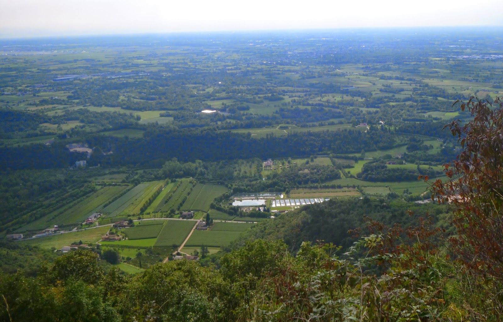
The long, slightly-downhill glide to Vivaro felt great.  I turned west and crossed the long viaduct over the Magredi.  I could see the mountains well from here, and it looked clear up to Caldastia on Piancavallo.  So I decided instead of continuing along the plain, I would head upward.

The climb was pretty easy at first, then went to 11-12%.  I decided to climb standing as much as possible to keep in practice.  So I stood probably two-thirds of  the time.  The long stretch of 13% below Rifugio Bornass was an especially good workout- really worked on deep breathing using both intercostals and diaphragm.  The average grade from start of climb to Bornass is 9.6%.

After Bornass I continued toward Caldastia despite the menacing black clouds rolling in.  Alas at 845 meters big, fat, frigid rain drops started coming down.  I turned around and the rain picked up, like it was chasing me.  A little ways below Bornass it let up.  Had a great time on the curves and switchbacks- this is about the best paved descent around here.

At Pedemonte I turned toward home.  Predictably, as I approached Giais the rain started back up.  We live in a perpetual rainshower.

Good ride-  930 meters of climbing and 60km distance.


The gradient


Wednesday, August 25, 2010

Rifugio Bornass 2

This is another local test of strength- it starts 5 km from my house at Costa, on Via Pedemontane and immediately slants upward.  The first 1.3 km to Santuario Madonna del Monte average 12.5%, with stretches of 15%+.  After that it's quite easy, averaging 5.4% for the remaining 8 km to Rifugio Bornass.

My approach with 39x26 gear was to stand for the whole first 1.3km, grinding out semi-circles on the steeper sections.  After the santuario, I sat and enjoyed a quiet easy climb through the  woods on the mountainside.  I did stand for the u-turns at the ends of the tornanti, which are perversely steeper than the traverses in-between, in contravention of normal practice.  This easy climb finishes at 767 meters.

The descent is wonderful- freshly paved and widened, full of banked tornanti, chicanes, and long steep ramps.  You end up at Pedemonte by Aviano.  Then another 200 meters of total climbing home.  I had to hurry because Silvano came back yesterday and I promised to take him to the supermercato this morning.  On the way home he told me about catching granchi with our neighbor Toni (who stays in Lido) on the diga (I'm guessing he means the MOSE project).  Must be fun, and they sound delicious.  

Gradient

Thursday, May 6, 2010

Pedemonte - Rifugio Bornass

After 6 days of continuous rain, this afternoon we had a brief "period of brightness" as the BBC weather reader says. I hurried and jumped on my bike, thinking I'd go to Villa di Villa and search for the Strada di Patriarchi backroad to Il Cansiglio. But as I approached the turnoff for Piancavallo at Pedemonte, I glanced up, saw the clouds had parted and I could see Castaldia, where the parapendio jump off the slopes. On an impulse I turned right, thinking I'd ride up to Collalto at 1374 meters.

As I mentioned previously http://dolomiti-friulane.blogspot.com/2010/04/piancavallo.html it's a long steep ride, rated "Molto Impegnativa" by Passi e Valli in Bicicletta- Friuli. I managed to remain seated up to 650 meters but a stretch of 13-15% did me in. So I climbed standing until 767 meters at Rifugio Bornass. My plans to reach Collalto quickly disintegrated during this standing stretch, as a huge black cloud with lightening and thunder loomed overhead. Discretion being the better part of valor, I decided to descend at Rifugio Bornass. It was quite windy and started to rain. Once I got down to 300-400 meters the rain stopped. I rode as fast as possible the 200 meter climb home on Via Pedemontana. Another guy with the same idea shot by me in a blur. A second fellow went by a little slower so I jumped on his wheel for the 1 km flat ride through our town.

Once home the sky split open and it rained buckets. I was very glad I hadn't ridden to Villa Di Villa- I would have been drenched and then faced a long ride home.


Map


Gradient from kilometer 7 to 14


Monday, February 15, 2010

Rifugio Bornass

Short ride, but the climb makes a good workout. Started by riding down into the plain a bit to warm up. After Sedrano I continued to Aviano, where the long easy slope to Costa begins. After Costa, the road turns abruptly upward, with19% stretches until Santuario Madonna del Monte. From there it levels to 6% (which feels flat) and passes through some nice woods until the bridge over Torrente Ossena. From there it follows switch backs up the slope, reaching 10% at times, finally reaching Rifugio Bornass at 767 meters. The last few hundred meters there was some snow and ice, so I had to dismount a couple times. It was hazy/cloudy today so the panorama was less breath-taking than usual. The road descending from Rifugio Bornass to Pedemonte (in Aviano) has been rebuilt and is great- very fast and smooth.
From Pedemonte I headed home on my usual route, Via Pedemontane Occidentale, with another 200 meters of climbing.
Santuario Madonna del Monte (foto from internet)
Map