Saturday, April 27, 2013

Col Alto

The weather forecast called for rain all morning but at sunrise skies were clear.  I hurriedly dressed and hopped on my bike, but by the time I left home clouds had moved in and temperatures dropped.  I resolved to ride anyway and turn back when the rain commenced.  After a 6 km warm-up to Pedemonte I headed up Via Piancavallo, virtually deserted now that ski season's over.  This long climb gains over 1200 meters of elevation in 14.5 km, vying with Zoncolan for biggest altitude gain in Friuli.  At Castaldia (1100 m) I turned off for Col Alto and traversed through alpine grassland.  Around 1200 meters I was surprised to see patches of snow, which I rode through until a deep section stopped me dead and I fell into the soft snow.  From then on whenever I hit a snowy stretch I dismounted and walked across.  Finally in the beech forest at 1314 meters the snow cover continued as far as I could see, so I turned around.  My brakes were iced up so I descended very slowly at first, but soon they thawed and it was fast and fun as usual.  It never did rain while I was riding, but started shortly after I returned to Giais. 


End of the line today at 1314 meters

Beech forest (also a spruce) 1300 meters

Frozen alpine pond at 1200 meters


Thursday, April 25, 2013

Monte Rest - Sella Chiampon

Beautiful Spring day.  I rode up through Val Meduna to the start of the Monte Rest  climb.  This is one of the best climbs around here- well-made road through wilderness with spectacular scenery.  I was startled to see numerous long strings of caterpillars attached head to tail moving across the road in various places.  Been here many times before but never noticed that.

At the pass (1055 meters) I put on my windjacket and descended.  Lots of fallen rocks this time of year, some as big as my foot.  So descend carefully till they clean the road.  At the Tagliamento River you head steeply upward to Forcella di Priuso 655 meters then descend to SS52, the main road from Tolmezzo to Ampezzo.  

From here to Socchieve and then Preone where the next climb starts.  Val Preone is a very steep road hugging shear cliffs above the white water river below.  I made it to about 700 meters and had to stop to hyperventilate a while.  Luckily I was able to restart and finish the climb, avoiding the ignominy of pushing the bike to the top.

The meadows at Sella Chiampon, are gorgeous, covered with wildflowers and surrounded by mountains.  I continued along the road until I pulled over by a family that had finished hiking.  The man was very kind and advised me about a frane (landslide) ahead.  He thought I could dismount and make it along the narrow edge, but his wife was worried.  As it turned out it was no problem, I rode right along the edge without difficulty.  I'd intended to hike down to Cascate dell'Arzino, but I turned off too soon and ended hiking to the headwaters of the Arzino, maybe 500 meters above the falls.  By then I'd spent too much time and needed to get home, so I'll return to check out the falls later.

The descent down the Arzino gorge to San Francesco and Anduins was wonderful as always.  I was getting tired by now and despite plenty of sweet tea, fig bars, dates and almond-butter balls I was running out of steam.  I finally reached home, got in the bath, and promptly fell asleep.  Then Marilyn made me a big bowl of spaghetti, which brought me back to life.  

20-foot long train of caterpillars on Monte Rest climb

Photo doesn't capture how steep this is, but after
grappling up from the river this stretch finished me off 

Beautiful headwaters of Torrente Arzino above the waterfall

Note all the gradient above 10% on Sella Chiampon climb;
the dip at 70 km is where I stopped to "rest"


Sunday, April 21, 2013

Osservatorio Astronomico Montereale

Weather forecast called for rain so I resolved to stay indoors all weekend.  But a strange brightness appeared through the north window and I looked out the front door to find a patch of blue sky stretching to the southern horizon.  I pulled on my bike clothes and hurried away, down through Ponte Giulio to Vajont, Ravedis and Grizzo.  Here I headed up the steep road to Monte Spia and onward to Casera Val de la Roja.   A crowd had amassed here, with hikers heading up roads and trails in all directions.   I think it's a festival, maybe Festa della Mont?  I kept going on to end of pavement at the telescope dome (682 meters) and on a whim continued up the dirt/rocky road.  They've cemented the switchback ends, which is nice because those usually get badly rutted from tractor tires, heavy rain.  I made it up to 750 meters but the 12% gradient rocky road was too tough for me on skinny tires.  I may bring the pups here when the weather clears for a hike- very nice trail to Pala d'Altei at 1500 meters.  

I descended and the crowd was all down in the little park area to the north, maybe having lunch.  Great little climb and very close to home (5 km).


Tuesday, April 16, 2013

Pala Barzana

Since Il Cansiglio road was clear Saturday, I thought I'd retry Pala Barzana.  Rode up through Valcolvera and turned left toward Valdifrina before Poffabro.  This a nice secluded road, with a stretch of 24% gradient to keep you on your toes.  After rejoining the main road a barrier said it was closed.  I kept going to check it out.  No snow but they are logging along it so lots of tree waste.  No problem on the ascent, and I soon reached the pass at 830 meters.

The descent was less littered, just the usual small branches, rocks left over from winter.  That is until around 700 meters, when I encountered a large chunk of road slumped downhill.  I hopped off and walked along the edge.  A few hundred meters later 3 large boulders the size of a Fiat Cinquecento or VW Beetle had fallen from the cliffs and were blocking the road.   I apologize for not getting a picture of these, but I thought another boulder might crash down while I was framing the shot.

The 4km tunnel under Monte Fara was a bit nippier than I expected, but I survived.  Good ride, but be careful between Bosplans and Pala Barzana.

I suspect this tree was pushed over by a bear trying to get honey

Pussy willow blossoms on the fallen tree


Backlit version

Monte Raut (2025m) with clouds

Bad slump on the descent to Andreis


Saturday, April 13, 2013

Val Menera

Our first day of Spring weather!  It was still nippy when I started so I wore all my cold weather gear, but by the time I reached Coltura I had to strip down to short sleeves and bike shorts.  The climb from Sarone up the mountain was wonderful as always.  The road was completely clear of snow and not even damp, surprising after all the rain.  At La Crosetta (1118 meters) I put all my cold gear back on because of the altitude.  I continued on past the turn off for Monte Pizzoc, which was marked closed though appeared to be free of snow.  On across Il Cansiglio where the sun shone brilliantly and the remaining snowcover sparkled.  At Pian Osteria I decided to turn right toward Val Menera.  The road ends after a few km at an agriturismo which was advertising Alpago Agnello (lamb). A few campers were parked outback while their owners hiked around the area.   Because of the snow down in the valley I couldn't discern whether the road continues or turns into a foot trail.  Have to return in summer.

The descent was great, and when I reached Coltura I went through the same routine of stripping down to the bare minimum.  It felt hot to me, though other riders on Via Pedemontane were bundled up, face mask and all.  Nice weather continued through Aviano and Marsure till the crest of the hill at Giais, where true to its reputation, it was drizzling.        

Beautiful grassy meadows of Val Menera

The remaining snow, with mountains to the east

To northeast, with Col Nudo (2472 meters) cloaked in clouds

Looking back at Val Menera from the main road (for Tambre) 

A view of the pianura on the descent;
Aviano AB in left background, Polcenigo right foreground


Sunday, April 7, 2013

Il Montello

Il Montello is an Italian cycling mecca rising from the Piave River plain between Treviso and Conegliano.  The wooded hills were an important battlefield in World War I, and the combatants built numerous supply roads through the forest.  These have been retained, some paved and some dirt, and attract hordes of cyclists from the surrounding area.

I rode down via Cordignano and Godega di Sant'Urbano to Ponte di Priula across the Piave River.  From here I skirted the riverbank to Nervesa della Battaglia, where the Montello climbing begins.  I climbed to the ossiary where nearly 10,000 Italian soldiers are entombed.  I then rode along the Strada Dorsale, which follows the main ridge for miles, a beautiful undulating curvy road through the forest, with many chicanes.  There were hundreds of cyclists out riding with their clubs and da solo, like me.

I picked one of the dozens of side roads (called prese) and descended to Giavera del Montello, then headed onto the plain.  Got lost as usual but wasn't a waste because I found a magnificent church at Arcade, really seems like a cathedral from a big city.  I'll try to find a link and post it later.

Back on track, I retraced my steps to Pedemontane Pordenonese and home.  I'll have to do this again soon.   

 
WW I ossiary above Nervesa della Battaglia

Some of the beautiful farms along Strada Dorsale

Vineyards and olive groves


Monday, April 1, 2013

Caorle

Easter Monday is Lunedi dell'Angelo or Pasquetta for short.  This year it falls on April Fools, which seems appropriate for this ride.  I left early and the roads were deserted, but it turned out drivers were just sleeping late after yesterday's big Easter dinner and by mid-morning they hit the roads en masse.  Most of my ride was on back roads though, so no problem.

Below Pordenone I rode on SR 251, a beautiful wide, smooth 2-lane road devoid of traffic because everyone uses the autostrada.  At Portogruaro I switched to SP68, with beautiful views of Fiume Lemene through Concordia Sagittaria and further south.  Nice seeing ducks, swans, cormorants swimming along the stands of reeds, under the weeping willow trees.  I turned off SP68 and continued along the river on Via Fratuzza, which dead ended after a few km (damn Michelin maps!)    Back on SP68, the road was narrower with lots of potholes filled with loose tar and more traffic.  Same for SP42, the busy main road from Venezia to Trieste.  Luckily I soon turned onto the peaceful farm road down through Marango and San Gaetano.  Eventually this runs into SP59, the wide main road to Caorle.  Here things went a little haywire, with so many visitors headed for the beaches at Caorle there was a traffic jam several km long.   I rode along the road edge into the little tourist town which was packed with cars and people.  Not sure why because temps were around 10-12℃ with a brisk east wind.  People walked around in their coats, enjoying the sun on their face.

The ride home is flat to slightly upslope, and the angle  of the wind provided a welcome assist.  After Pordenone I got tired and took it easy the rest of the way home.  Fun ride!           
Weeping willows along Fiume Lemene south of Concordia Sagittaria

Pretty church along the water's edge at Caorle

Close up of church


Saturday, March 30, 2013

Manazzons

Today we had a 3-hour rain-free window so I rode to Celante to finish my interrupted ride from February. I continued down through the bosco to Pradaldon, then headed up to Manazzons.  This section is a steep climb, 1.3 km averaging 10%, with a few 13% spots in the mix.  From the hill above town you plummet back down to the road along Rio Coz and follow it back to Celante.  Made it all the way to Campagna before the drizzling started so only was slightly damp when I returned home.  Good ride.


Beautiful waterfall of Rio Coz above Pradaldon


Saturday, March 23, 2013

Troi dei Vuolth

Head north from Selva on foot to end of the gravel road (near our wideband repeater on a disused WW II bunker).  Head up the trail signed Troi dei Vuolth and follow the trail up to the alpine meadows at Baitola Polo.  There are great views from here of the mountains above, the plain below, and steep scree canyons on either side.  Next time I'll  continue on the Troi dei Vuolth to Palussa, another mountain cabin for hikers.

Tried out the trekking poles my mountain-running friend Doug recommended.  They're great- let you use upper body muscles to augment lower body when climbing, and help with balance when descending.  Love 'em.


Cavern high in Li Gravis canyon 

Selva from 800 meters

Valfreddo (1307 meters)

This ridge at 1300 meters obscures view of
Monte Ciastelat (1641 meters) on other side

Pala Fontana high above (1637 meters)

Baitola Polo (813 meters)

Framoso canyon/scree slope


Thursday, March 21, 2013

Giro del Prosecco

Paul Kim showed me this route last year and I'm finally getting round to riding it solo.  After Vittorio Veneto you climb up over peaceful Passo di San Lorenzo.  Then you coast down to Tarzo, up again along the ridge to Resera, and down to Rolle.  Here begins a beautiful little winding road down through the bottom of a valley covered with prosecco vines.  You continue down to 186 meters on Via Molinetto, then begin to climb up through  Refrontolo and along the ridge to San Pietro di Filetto.  Here starts a beautiful loopy series of 8 tornanti gliding down through the prosecco vines to the intersection with the main road from Tarzo to Conegliano.  Go straight across and continue to Cozzuolo, then descend to Vittorio Veneto.

Amazingly at Vittorio Veneto I caught a tailwind pushing me at 30+ kph all the way to Fiaschetti.  From there up the hills and home.  Wonderful first ride of Spring. 

Looking back at church and Monte Pizzoc
from Passo di San Lorenzo

Bare prosecco vines from the ridge above Rolle


Cascade at Rolle

Some of the tornanti below San Pietro di Filetto 


Tuesday, March 19, 2013

Rifugio Bornass

Not sure why I waited 18 months to check this road after it was washed out by flooding.  It's only 3 miles from my house but somehow it never occurred to me.  But today I had a spur of the moment impulse and rode up there.  It hasn't been repaired yet, but it is passable on a bike if you put on some cleat covers and carry your bike along the edge a little way.  After that, it's a peaceful climb up to 784 meters, then a fast descent down the main road from Piancavallo.  The road was wet so I took it easy on the bends, but still hit 75 kph on the straight stretch.  What a great workout!


The barrier at 412 meters; you can climb over/around it on foot

A view into the abyss
Just carry your bike along the right edge


Looking back with relief at surviving


The second washout, on the west side of Torrente Ossena


Friday, March 15, 2013

Monte Cuarnan

Our rainy days were blown away last night by the Bora, unfortunately dropping our temps to near 0℃ and blowing strongly all through today's ride.  Non c'è male though; any day on your bike is a good day.
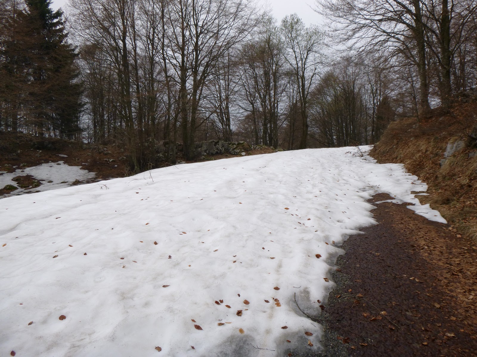
I left early, riding up through Pinzano and Trasaghis to Gemona.  The toughest part of the ride was climbing up through Gemona- very steep streets with dead ends and one-ways to make you double track after you've struggled up a street.  I finally found Via Cappucchini and Via Gieseute, which traverse across the mountain to the start of climb, Via Foredor.  These first few kilometers are very dolce climbing, allowing me to recover from Gemona.  The sweetness gets a bit steeper later, until you reach a little box canyon connecting Monte Chiampon and Monte Cuarnan.  This traverses to the steeper Monte Cuarnan climb, with metal drainage channels every few meters.  It got quite cold here despite exertion.   The normally silent forest was hit by a wind blast every few minutes, which sounded like a freight train blowing through the trees.  Up around 800 meters started running into patches of ice and snow but was able to get through till about 950 meters.  Here the road was snowed over, and even a mountain biker whom I'd passed on the hill earlier was struggling.  He eventually gave up and started walking his bike up to the malga.
The descent was freezing cold, despite going slow to avoid ice, bunny hop channels, etc.  I turned off the main road and took Via Baldo, a very steep street with drainage channels.  I was trying to find the road to Artegna, but got a little lost and finally spotted it in the distance from a cliffside.  This is a great road, much nicer than the busy route from Trasaghis.  I continued through Buia and Majano then across the Tagliamento to Cornino and back down through Pinzano.  Luckily the Bora was to my back now  and I got to rest a bit.  Great ride!    


Monte Chiampon (1709 meters, left) and
Monte Curnan (right) across the Tagliamento

The mountains beyond Tolmezzo from 950 meters

Prealpi Carniche in background,
Monte Brancot, foreground

Prealpi Carniche stretching further to the west;
in left background you can see Monte Ragogna by the river

Monte Chiampon towering above 950m clearing
on Monte Cuarnan

Wednesday, March 13, 2013

Valcellina- Val Meduna climbs map

Here's a map of some good climbs in Valcellina area.  For now you must click on the green bike place marker to see name, link to description, etc.  I'd prefer a label to pop up when you scroll over the place marker, will work on it.


View Valcellina- Val Meduna in a larger map

Sunday, March 10, 2013

Val Ciadula

Finally the rain let up a little today and merely drizzled.  I rode up Valcellina; after Barcis at Arcola the rain picked up a bit but still not bad.  I decided I would continue to Claut and then return home.  As I entered Claut I noticed a little road winding way up the hillside and thought "Too bad- if it wasn't raining I would try that."  I did a little lap around the centro of Claut and the rain stopped.  So when I returned to the turn off I decided to go for it.  The road is marked Via Grava Ruggero at first, then becomes Via Creppi.  The narrow farm road winds steeply up the hillside through wild stretches alternating with small groups of farmhouses with pasture.  In a couple of spots the road was snowed over so I charged through it until the bike stopped and then carried it a few meters.  The fun finally ended at 819 meters where the pavement ended and turned into a rocky trail.  Going down was hairy because the brakes were iced over.  I stopped and cleaned them after each snowy stretch but the steepness (16% at times) kept me from slowing down real well until I reached a flatter spot.

The ride home was wonderful- slightly downhill almost the whole way so felt like flying.  The new Pearl Izumi windstopper gloves were absolutely dry inside- very impressed.  My old neoprene shoe covers still let some water in though, I think after 15 years they may deserve retirement.


End of pavement at 819 meters

Looking back down Val Ciadula toward Claut

View of Claut from Creppi
View toward Valcellina from Creppi