Friday, August 17, 2012

Passo di Prato Piazza - Lago di Braies

Around 0630 I started at Villabassa (1121m) near Dobbiaco in Val Pusteria, Trentino Alto Adige.  I warmed up briefly on the pista ciclabile toward Brunico, then turned left onto the road for Prato Piazza. It was chilly and overcast- I worried the summit might be socked in.  At first the ascent is very gentle, with wide, sweeping switchbacks leveling the grade.  Then after Ponticello (1491m) the average gradient increases to around 7%.  Around 1800 meters you exit the dense forest and begin a steep section of around 13%.  This eases as you enter Prato Piazza (1970m) and the asphalt ends, changing to hard-packed strada sterrata.  

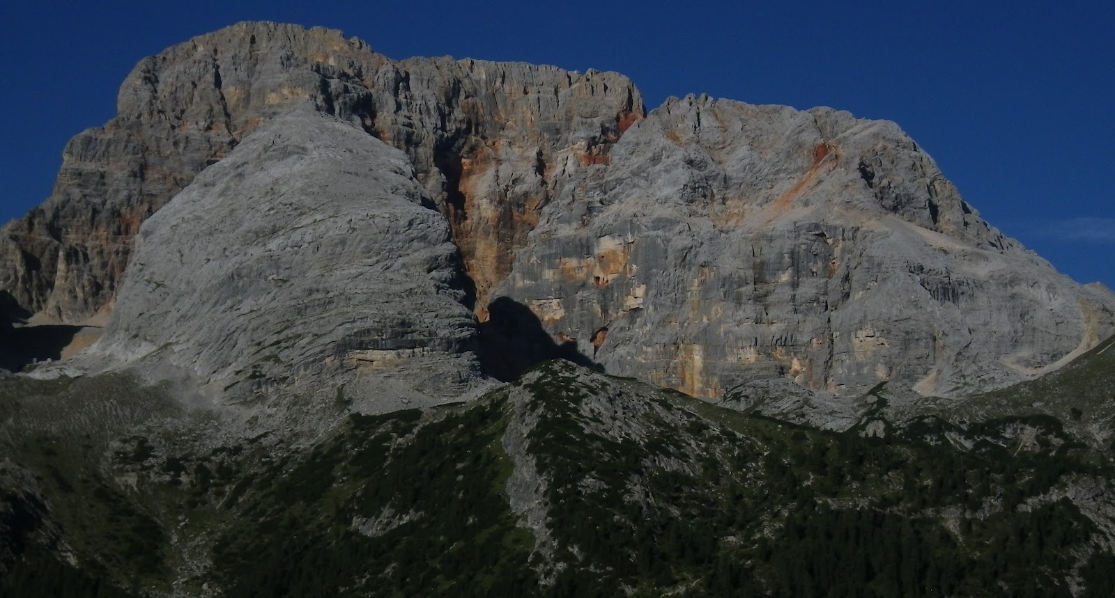
By now I 'd climbed through the layer of overcast and into crystal blue sky.  This place has about the biggest spread of bright green meadows I've ever seen.  These are surrounded by lovely peaks, foremost among them La Croda Rossa (3146m).  It has very striking veins of blood red stone on its cliff faces.  I first noticed it last year from Tre Cime di Lavaredo, and then again a few weeks ago on the road from Dobbiaco to Cortina.  

The strada sterrata climbs slightly to the pass at 1992m, with fantastic views of Le Tofane (3244m) high above  a sea of clouds overlaying Cortina.

Now I descended (cautiously because of the ascending traffic) to the left hand turn (at 1180m) for Lago di Braies.  This starts even more gently upward through rolling pastureland until around 1350m, where a long gradient carries you to the lakeshore at 1480m.  Already very crowded here in the morning, but I tried following a trail counterclockwise along the shore, till it became all wooden stairs and catwalks along cliff faces where I turned back.

I would highly recommend visiting Prato Piazza, whether you bike, drive or take the bus from the village below.  It's really spectacular.    

La Croda Rossa above the Prato

Close up La Croda Rossa

Close up La Croda Rossa

Veins of blood red stone


The long ridge above the east side of the Prato 
Ridge flanking west side of Valle Landro
Close up of icy Austrian peaks to the north 
Le Tofane above cloud-shrouded Cortina

Note mountain bike road descending toward
Lago Misurina and Cortina from Prato Piazza

Beautiful meadows the Lago di Braeis road traverses 

Croda del Becco (2810m) reflecting on Lago di Braies
The promontory on the lake's west side

Not part of bike ride: waterfall on Torrente Padola
(along climb to Passo Monte Croce di Comelico)

Another view of the cascate


The bike ride

Climb to Prato Piazza


Climb to Lago di Braies

Tuesday, August 14, 2012

Passo di Pampeago - Passo di Lavazè

Alpe di Pampeago has seen 5 Giro d'Italia finishes, including wins by Marco Pantani and Gilberto Simoni.  Roman Kreuzeger's win in the 2012 Giro was a bit different, because instead of ending at the ski area parking area (1763m), the road had recently been paved all the way up to Passo di Pampeago (1996m).  When I saw the stage I wanted to go check it out.

It was very overcast and raining steadily as I drove from Agordo to Moena- I almost turned around but decided I'd drive to see Cavalese and Val Fiemme if nothing else.  But as I continued through Predazzo the overcast brightened a bit, and shortly after I parked at Cavalese blue sky started peeking through.

I traversed from Cavalese (1010m) along the mountainside to Tesero (987m), where I turned left and began the Passo di Pampeago climb.  The first 4 km up to the junction for Passo di Lavazè at 1277m averages 7.4%, with much 9-12%.  Now I was definitely warmed up despite the cool temps, and tossed my windjacket into my zainetto.  The next stretch is the most difficult: 5 km of 11.5%, with much 13-14%.  It's a straight road, no switchback ends to catch your breath in, no less-steep spots, only more of the same.  Even 3 short tunnels maintain the gradient.  As you pass Alpe di Pampeago ski area, the grade finally drops to 10%.  Now you begin the newly paved road winding up through the ski slopes.  Around 2000 meters the road levels out, and then begins to descend.

The descending road deteriorates somewhat as it descends more steeply through fir forest, then you enter the upper slopes of another ski area and the pavement is new again.  You descend quite steeply past a ski area, and then a wide paved road continues plummeting down to Obereggen (1561m).  I turned left toward Novale and dropped further to 1276m.  Here you turn left onto the main road for Passo di Lavazè, climbing 3 km through dense fir and larch forest at 10% average gradient, followed by 3 more kilometers of tornanti averaging 8%  It levels out at 1808 meters in pastureland.  On a whim I turned right toward Passo degli Oclini, an easy 4 km climb to 1989m.  More pretty green pastures and some rocky summits.

Back at Lavazè I descended rapidly down  to Cavalese.  Though it wasn't yet 11 AM there were already traffic jams of tourists here.  Time to get outta Dodge.    

Looking back down the Alpe di Pampeago climb from 2000 meters

Promontory north of Passo di Pampeago

Capitello at Passo di Pampeago

Monte Latemar (2842m)

View from Passo degli Oclini

Corno Nero (2439m) at Oclini

Close up Corno Nero with grazing cattle

View toward Cavalese from Passo di Lavazè


Counterclockwise: traverse from Cavalese and climb to Alpe di Pampeago

Counterclockwise climb to Passo di Pampeago, descent to Obereggen, down to Rauch,
then climb to Passo di Lavazè

The side road to Passo degli Oclini and descent to Cavalese

11.5% average gradient for 5.3km; the oddity at km 12 
is GPS reacquiring satellite after a tunnel 

Sunday, August 12, 2012

Eisentalhöhe - Nockalmstrasse

Nockalmstrasse is a scenic mountain road in Austria through Nockberg National Park.  These are large grassy dome mountains of karst stone, with beautiful pastoral valleys,  forests of larch and spruce, and tumbling whitewater streams.  I decided to try climbing the highest of the domes, Eisentalhöhe, whose road reaches 2049m (where you can start a hike to the summit over 2400m).

At 0700 I found a spot to park at Eisentratten (800m), a village on B99 between Gmünd and Krembrucke in the shadow of the autobahn high bridge connecting Italy with Salzburg.  It was overcast and chilly.  I warmed up on the easy gradient to Krembrucke, then turned right and climbed up a lovely gorge along whitewater to Innerkrems (1500m).   Here you begin the actual climb, passing through a tollbooth where cars and motorbikes must pay.  The road is well-paved with excellent switchbacks clambering up the slopes.  It climbs first through forest, then onto the open grassy bald.    I was quite warm from the exertion when I reached the trailhead for Eisentalhöhe and the morning sun was shining brightly, so I thought I'd continue down the short descent to Steigerhütte (1481m) in my short sleeves.  Felt great but when I reached the low spot I was cold.   I turned around and warmed somewhat climbing back up to Eisentalhöhe.  There were many cows along the road/in the road/walking from one pasture to another, so I had to stop climbing a few times, cooling off again.  Back up at Eisentalhöhe I donned my windjacket and headed rapidly downhill toward Eisentratten.  Very fun descent, though tourist traffic was now picking-up.

I'd like to return and climb the opposite side from Ebene Reichenau (1095m) up to Glockenhütte (2004m), then down to Steigerhütte, or maybe up to Eisentalhöhe again.  A loop along the shore of Millstäter See looks possible, though I'd try it in off-season when tourist traffic lessens.

Cows enjoying the sun on the summit high above

The view west from Eisentalhöhe

More Nockberg peaks to the south

Looking down toward the meadows at Steigerhütte,
with Schiestlscharte (2024m) in background

Looking west again, with the Mölltaler glacier (3122m)
now shining in the sunlight


The complete ride

Climb from Innerkrems

Descent to Steigerhütte meadows

8.8% average early section of Eisentalhöhe climb


Reclimbing from Steigerhütte meadows up 9% average grade

Friday, August 10, 2012

Passo delle Erbe

Passo delle Erbe in Trentino Alto Adige is new to me, but I've seen a couple of reviews of the climb: one called it their all-time favorite climb, and another ranked it second only to Passo di Giau.  So I was curious and had to check it out.  

I arrived at the starting point south of Bressanone on SS-12, at a turnoff marked Val di Funes (540m).  I warmed up for a couple of km on a side road but it wasn't enough: the climb starts with 2 or 3 km of 9-12%, so it would have been better to have a few more miles in my legs.  The road climbs through the gorge of Rio Funes, then eases a bit as the gorge opens into grassy meadows below spruce-forested slopes.  I was surprised at the amount of traffic- lots of people commuting to work, and delivery vans/trucks headed upslope.  Then later in the morning the vacationers began arriving.

Soon you arrive at San Pietro (1100m) and continue through the little town with many tourists.  The porphry-block paved street for Passo delle Erbe turns to the left and begins climbing.  It's very narrow, steep and bumpy.  As it climbs out of town the pavement changes to asphalt but continues as steeply and narrowly as ever.  This finally lessens briefly, but resumes again and again in the next couple km.

Around 1600m suddenly the climb transitions to false flats and soon even a slight descent.  This ends in a beautiful pasture-covered amphitheater surrounded by dolomite peaks.  From here some more moderately difficult climbing to the pass at 2004m.  The road is a bit too busy this time of year considering the narrowness- 2 vehicles cannot pass one another without finding a wide spot, so lots of backing up, waiting, etc.   No big deal, but I'd recommend not driving up here in vacation season.

I have to agree with the other two reviewers: this is a gorgeous climb through some fantastic wild scenery.  And even this time of year there were moments when it was deserted; you could get a feel for how it might be in June or September.  There are also numerous ascent routes, allowing many loops and variations.  I'll definitely be back, and will try the climb up from San Martino in Badia next time.

One of many apple orchards covering Trentino Alto Adige

San Pietro church campanile

Wider view of San Pietro and Val di Funes

Pretty meadows above San Pietro


Monte Tullo (2654m)

Close up Monte Tullo

Sass de Putia (2875m)

Close up Sass de Putia

Plose grassy dome (2465m) above upper Val di Funes

Higher view down Val di Funes

Le Odle (3025m) above Santa Maddalena in Val di Funes

Looking back at Monte Tullo from above San Pietro

Pretty wooden-steepled chapel at Pradello

Castel Summersberg at Gudon, high above Rio Funes

Wildflowers along Rio Funes


Some of the steepness climbing out of San Pietro