Sunday, April 11, 2010

Val d'Artugna

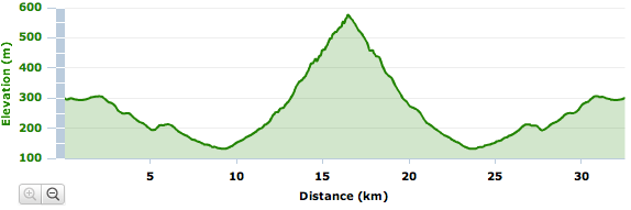
Quick ride down Via Pedemontane Occidenatale to Dardago, then up the climb through the Val d'Artugna. It's between 7% and 10% for 3 or 4 km, good pavement, and lovely scenery. I posted about this route previously in January ( http://dolomiti-friulane.blogspot.com/2010/03/giais-val-artugna-dardago.html ) but that time I stopped at the barrier (450 meters) because of ice higher up. This time I continued up to the end of asfalto at 577 meters. The descent was great- very fast. Rode up the 200 meter climb toward home quickly, even passing a paceline (GS Pratenese bike club), but in fairness they had just just come down from Rifugio Bornass, so they were probably pretty tired. Great ride!


Looking back down the valley toward the plain


Map


Ride profile


Thursday, April 8, 2010

Lago Cà Selva

Rode through the Bus di Colvera to Poffabro, down the Val Muiè to Val Meduna. Then across the dam at Lago dei Tramonti, along the shore to Chievolis. Then steeply upward along the wall of the Torrente Silisia gorge to the dam at Lago Cà Selva. Great workout (numerous stretches of 10%) through spectacular scenery. Loved hearing the white water roaring far below in the gorge. Want to do this ride again soon.


Snow melt in the Bus di Colvera


Arm of Lago dei Tramonti at Chievolis


Rapids and chutes in Torrente Silisia


Chute (waterfall?) far down in the gorge


The climb along the gorge wall to Cà Selva


Beautiful blue wildflowers


Map


Ride profile


Tuesday, April 6, 2010

Selle Chianzutan

Beautiful day. Rode to Pinzano, up the tornanti at Anduins, up the gorge of Val d'Arzino. The river was full of snowmelt and I could hear the roaring rapids far below. Continued through the forest past Pielungo to San Francesco where the actual climb begins. The road ascends above the river awhile, with spectacular views of chutes and waterfalls. At Pozzis the road veers away and heads up a series of long tornanti through steep fir-covered slopes.

Around 900 meters the road becomes less steep and enters a huge meadow. The selle has a few farm houses surrounded by pastureland, flanked by Monte Verzegnis on the west and Monte Piombada on the east. To the north are wonderful views of the snowy peaks beyond Tolmezzo.

The descent is very fast and curvy on wide smooth pavement. It then joins SS 512 and heads east toward Laga Cavazzo. The lake is beautiful blue-green in the sun. Then southward on Strada di Bottecchia along the Fiume Tagliamento, full of azzure snowmelt.

Wonderful ride, and you can see it during the Giro this year early in the Zoncolan stage. Should be awesome from the helicopter- don't miss it!


View of the Arzino down in the deep narrow gorge

Monte Rest to the west


Waterfall in the Arzino near Pozzis


Monte Verzegnis with dolomite formation


Mountains to the north from Selle Chianzutan


Monte Arvenis


Mountains to the northwest of the selle


Center: group of dolomite spires, (Stonehenge?)


Across Lago Cavazzo to Interneppo


Fiume Tagliamento from Strada di Bottecchia


Map


Ride profile


Friday, April 2, 2010

Monte Valinis

This was a surprise ride. I planned to climb up the Val d'Arzino to Selle Chianzutan, then descend to Tolmezzo, return along the Tagliamento River to Pinzano. But the previsione from www.ilmeteo.it was overly optimistic- after Sequals it started raining. So I turned toward Travesio, but when I saw the heavy clouds and rain above Clauzetto, I had to change plans again. I headed to Meduno, and on the spur of the moment headed up toward Forchia Meduno, 630 meters . It's pretty steep at first (10-12%) but settles down to 8-9% after awhile. The scenery is fantastic- fir trees, beech trees, karst rock formations, and beautiful panoramas in all directions. At the forchia I decided to try going to the parapendio jump-off point. The road was easy through the forest to Forchia Piccola, then turns upward, a steady 10% for a couple km, then onward at 8%. At Forchia Tamer (940 meters) the asfalto ends, but I continued up the gravel road a few hundred more meters to the end of the road on Monte Valinis, at 986 meters. Wonderful fast decent and then fast all the way home (must have been a tailwind). I want to do this climb again.


Frisanco from Borgo Bianco


Fiume Meduna


Fiume Meduna and Magredi in the distance


Monte Raut from Monte Valinis


Cavasso Nuovo foreground,
Torrenti Colvera and Cellina behind


Magredi di Fiume Meduna


Colline di Sequals foreground,
Fiume Tagliamento, background left


Map


Ride profile


Thursday, April 1, 2010

Sunday, March 28, 2010

Anduins Pielungo Campone

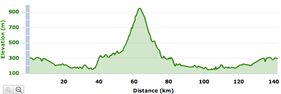
This ride contains 2 climbs I haven't tried before (though I have ridden them downhill). The first is from Casiacco up to Anduins- 10 tornanti at 6-8% for 2 km. Not bad, and the scenery is beautiful- numerous white water streams racing down the steep slope toward Fiume Arzino. After Anduins you reach the edge of the gorge of Val d'Arzino. I stood on the pedals often so I could look down at the beautiful emerald and white water churning over boulders far below. At Pielungo, I turned away from the Arzino and up the lonesome mountain road to Orton. It's a long steady climb through beech forest and eroded karst stone formations up to 630 meters. Toward the end the solitude was interrupted by a few cars in an old-timers rally- mostly 1970s Lancia Fulvia, Alfa Romeo, Fiat and even a few Autobianchi. After the summit I rolled down to Pradis di Sotto and then headed up again toward Piani di Clauzetto at 670 meters. Then down again along the Torrente Chiarzò, through Campone, to the Meduno River and home. 100 km ride.
Some nice pics of the Val d'Arzino here http://www.valdarzino.it/lab_foto_gallery/

Tornanti di Anduins
Anduins-Pielungo-Campone
Ride profile
Elevation Gain:1,176 m
Elevation Loss:1,196 m
Min Elevation:138 m
Max Elevation:658 m

Thursday, March 25, 2010

Poffabro-Campone-Clauzetto

I've ridden individual parts of this ride before but never altogether. To start I headed up through Bus di Colvera to Poffabro, then down through the Val Muiè to Navarrons- see pictures here: Meduno-Poffabro . Then I rode up the Meduno River road to Lago di Redona and turned right, following Val Chiarzo' past Campone and up over Piani di Clauzetto at 676 meters ( see Orton ). From there I descended to Pradis di Sotto, turned right and climbed back up to Clauzetto (600 meters). Great descent down the Val Cosa to Travesio, then across to Sequals. At Sequals it started raining pretty steady. Wasn't too bad, though my wet socks were cold in the wind. Continued through Arba, Campagna back to our house, and thawed my feet in a warm bath. Great ride.
Map
Profile

Tuesday, March 23, 2010

I Magredi

This is another questionable post- it is not about cycling in the Dolomiti Friulane. Instead, it's about cycling in the Magredi (see http://www.assiemeperiltagliamento.org/forum-magredi/praterengl.htm ) an expanse of dry river beds on the pianura between the Dolomiti and Adriatico. It's covered with rocks torn from the Dolomiti by glaciers, and then strewn across the plain by huge floods. Very desolate, mostly-undeveloped area protected by WWF.
Today was the warmest so far this year, so I wore short sleeves and bike shorts, fingerless gloves, and no shoe covers for the first time since Autumn. Felt great, though rather windy. I noticed several approaching motorists donning protective eyeware upon seeing my unbearable whiteness of being- hopefully I'll turn beige before long, if not bronzato. Oddly all the Italian cyclists I encountered had on long sleeves, long pants, shoe covers, etc. I would have been soaking in sweat with that on.
I headed down to Vivaro and continued almost to Rauscedo, where I got on the new road from Spilimbergo to Zoppola. It is limited access, so no cross-traffic, has a nice bike lane on each side, and is elevated a bit so the pavement isn't washed away by the annual floods. I turned off on the road to Cordenons, then continued through Arco and Roveredo to Castello d'Aviano. From there continued on the climb home. Nice Springtime ride.

The Magredi, with Dolomiti Friulane in background- from internet


Castello d'Aviano- from internet

Map


Thursday, March 18, 2010

Pala Barzana

I tried this in February but the road was still snowy above 650 meters (see Poffabro ). So yesterday I was looking around with my binoculars from the top of Monte San Loenzo, saw the switchbacks on the road to Pala Barzana, and thought I'd give it another try.
The road was open all the way to the top and down the other side, past Bosplans, to Andreis and Molassa. Very nice ascent- above 600 meters the road winds through a fir forest, and the fir-needle covered understory and snow soaked up all the sound. Silent except for singing birds. Nice and sunny in the meadow at Forcella di Pala Barzana (842 meters), with Monte Raut towering on one side, and Monte Fara on the other.
Descended slowly, as the road had a lot of cinders and pebbles from the winter, and I wanted to remain upright. After Andreis the road was better and I could pick up speed. Then through the 4 km tunnel under Monte Fara, across the bridge over jade-turquoise Lago di Ravedis, and home. Fun ride.

Map

Profile

Wednesday, March 17, 2010

Monte San Lorenzo Hike

Forgive me but this post has nothing to do with cycling. I did see a sign pointing to this hike while riding the other day. And hiking up steep hills seems like good cross-training. That's the only connection I can think of.
I put my two little dogs in their crate and drove to Fratta, a frazione northeast of Maniago. We parked at a little piazzetta at the junction of the road from Val Colvera and the bridge over the Colvera from Fratta. The hike starts inauspiciously in what seems like a dry ditch with paving stones between two houses. But there is a big stone with blue and white stripes, so this is it. At first there are some discarded roof tiles and other rubble in the ditch, and you wonder what you've gotten into. But after a few meters it gets pretty, a nice shady stone path a bit lower than the surrounding land, sunken with the passage of time like still-visible stretches of the Oregon Trail in the American West. The stones are often flat and appear to have been squared off to fit together. This is apparently the remnant of a roman road, which I've read once passed up the valley to Monte Rest and beyond to Carnia. It is a beautiful place in mid-March, covered with wild violets and primule.
Eventually the trail deviates from the road and heads uphill to the left. After much moderate climbing you reach old houses and buildings in a meadow called casera Gravena at 470 meters. There were dozens of bee hives- I'll have to look for this honey at the market. On several trees Attenti al Cane! signs warned of a vicious-looking pastore tedesco with blood dripping from enormous canines. I anticipated grabbing my dogs to save them from the beast. A 3 or 4 kilo fluffy back and white terrier ran out yapping. What a relief!
The trail went right through the property- I walked by two men, one on a ladder sledgehammering a rough-hewn tree limb post into the ground while the other held it straight. I said Bon di! and they replied, so I guess I wasn't trespassing. I'd rather not displease a man holding a 10 kilo sledge over my head. The trail now comes to a dirt road. I missed a turn, so walked along the road for a couple hundred meters to a sign warning Sparo Mine! with blast times. So I turned around and was more careful, finding the unmarked narrow path turning steeply up the wooded slope. It was maybe a 30% grade, and I was grateful for my pups tugging with all their might to keep me from tipping over backwards. It kept on like this for quiet a while, finally breaking into the alpine grass and heather near an angle-iron crucifix.
We rested a bit then continued up the meadow to the chiesetta di San Lorenzo, a 13-century church. It's a lovely spot for a little church out here all alone, with a pretty alter inside. From there the ridge follows a series of whoopty-doos, each slightly higher than the last, so you keep thinking you've reached the top till you get there and there's another behind it. Finally it's the real one at 736 meters. You can go a bit further down slope to a wire marked Ciglio cava. It's a cliff several hundred feet more-or-less straight down, where they've chopped away half the mountain for crushed rock to make cement. Thank God they've stopped before the top and haven't destroyed the chiesetta.
I took some pictures of the fantastic 360º panorama. Monte Jouf above Maniago is to the west, then a few craggy dolomite peaks along the Cellina, Monte Raut, snowy Monte Rest to the northeast, down below Val Colvera, the top levels of Poffabro, the little village of Vals, past Meduno in the distance the castello di Toppo, on the plain, Fanna, Maniago, Montereale. Wow.
We headed back down. The pups were good about not pulling too hard- good thing as I'd probably have toppled down onto them. They got a special treat when we got home for being such great hiking companions.
Roman road
Further up the roman road
Crucifix in heather
Maniago, Piazza Roma
Chiesetta San Lorenzo, 13th century, near summit
The little campanile
Val Colvera
Monte Raut
Wild primule
Wild violets
Map
Profile