Thursday, July 8, 2010

Lago di Santa Croce - Vajont Dam

A long easy ride through some spectacular scenery. Cruised down to Vittorio Veneto, passing a plethora of riders heading up the Strada Pedemonte Occidentale, including a large club ride. Climbed up the gentle slope to Sella di Fadalto 487 meters, then Lago di Santa Croce. It was a bit cloudy so I didn't take many pictures of the lake, but it was gorgeous as always.

The stretch through Ponte nelle Alpi to Longarone has pretty scenery but is too heavily trafficked, with trucks, tourists towing campers, etc. Maybe a Sunday in Spring or Fall would be better though. There are some narrow bridges where a trailer blown sideways a bit by a strong wind gust could easily knock you off into the gorge. I would recommend driving to Longarone and then climbing to Vajont dam, or riding from Montereale to Longarone, and then turning back. Riding a loop instead of an out-and-back in Summer isn't worth the risk, IMO.

The much more peaceful road from Longarone crosses the Piave River and then heads up some lovely gentle tornanti to a tunnel near the dam. It's a good tunnel, wide, well-paved, with lots of lunetti for fresh air, sunlight and glimpses at the scarily deep abyss below the dam.

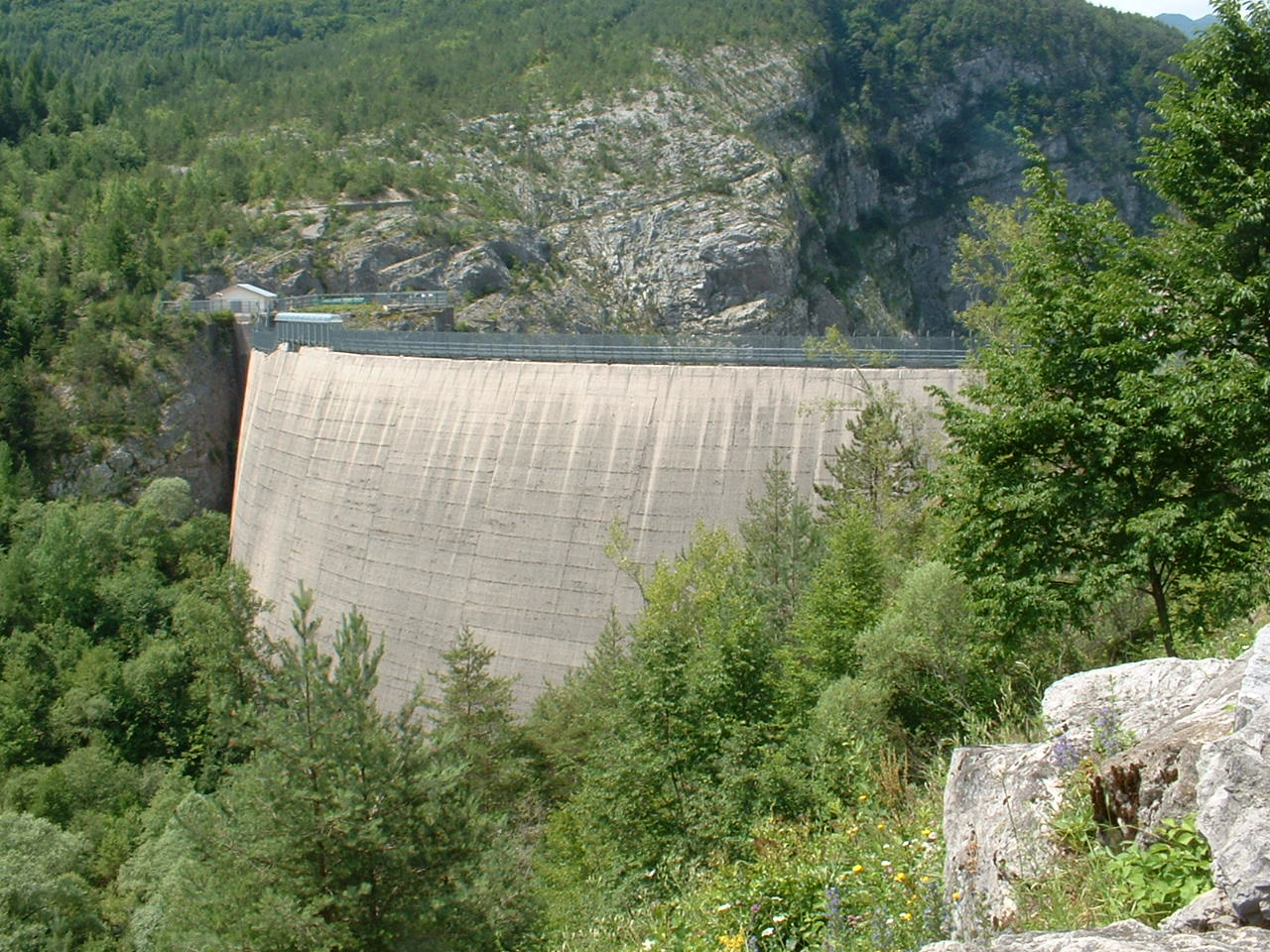
After the tunnel you reach the dam. It's a very eerie place. In 1963 the 250 meter deep lake behind the dam was suddenly filled with a huge chunk of Monte Toc, which separated and dropped into the lake. It displaced the water, creating an enormous wave which shot over the dam and rushed down the narrow gorge to Longarone, killing 2,000 people. Pictures afterward of Longarone look like an atomic bomb site- nothing but gravel, mud, debris. Today the dam is disused- the waters of Torrente Vajont bypass the dam and flow directly into the Piave River.

After the dam I rode through the altopiano, past Erto and then up to Passo San Osvaldo 836 meters. Nice fast descent to Cimolais, then down the Valcellina. The river looked great- still plenty of azzurro water, white caps in the rapids, natural music.

I'll probably try this in the opposite direction next Fall on a Sunday. I also see a possible alternate route via Soverzene so I'll see if that avoids the bad traffic.

Punta Trifina a Lago di Santa Croce


Fiume Piave at Longerone. Peak is Spiz Gallina, 1545 meters


From Longarone, looking up gorge of Torrente Vajont


Upstream il Piave toward Monte Sassolungo 2413 meters


Village of Podenzo, pink cliffs above Longarone


Vajont dam from behind


Vajont dam, with Longarone visible down the gorge


Casso, on cliffs high above the dam, was hit by the wave


Eroded dolomite on mountain above Erto


Monte Toc, showing the scar of the landslide


Col Nudo, 2471 meters, in the clouds


The remnant of Lago di Vajont


Passo San Osvaldo, between Monte Lodina e Monte Cornetto


Map of the loop


Elevation profile of the loop


Tuesday, July 6, 2010

Monte San Simeone

This is a relatively unknown climb from Bordano (a town famous for butterflies and murales) to the top of Monte San Simeone (1505 meters). The paved road stops in a beautiful alpine meadow at 1168 meters- you need to hike or mountain bike to reach the summit. The paved portion is 10 km at an average 8.3% grade- great workout!

The climb starts around 300 meters at the saddle on the road between Bordano and Interneppo. The first stretch is through shady forest, a very nice 7% climb up to the junction with the road to Monte Festa. That will be another climb I'll try soon- there is a big World War I fortress up at the top.

The road continues through the forest and steepens a bit. The asphalt-and-pebbles pavement soon ends, replaced in sections with concrete. One stretch is quite bad- the surface is all lumpy, like the batch of concrete turned out bad. But most of the concrete is quite smooth. Soon the road begins a series of long switchbacks, partially shady with some openings with great panoramas. The grade stays generally in 8-10% range, with a few stretches of 13%. There are about 10 very short tunnels, mostly curved. This continues uninterrupted for 10 km.

My lower back got sore from all the seated climbing, so on the upper half of the climb I switched to standing on sections of 11% or more. This helped. There were butterflies flitting around and I finally found one sitting still long enough to photograph. At 1100 meters the road enters a wildflower-covered meadow, with stupendous views of the surrounding mountains, and the Tagliamento far below. At 1168 meters the concrete pavement ends and a dirt road continues toward the summit. Another footpath leads to the Chiesetta di San Simeone. I thought about slipping on my cleat covers and walking the 200 meters to the church, but a menacing black thunderhead changed my mind.

The descent is very slow because of loose stone and leaves etc on the roadway, as well as all the curves limiting visibility. Most of the curves have no guardrails, so if you made an error you'd have a lengthy plummet. Finally I arrived at the junction, rode the smoothly paved main road down to Bordano, then continued between the cliffs of Monte Brancot and the Tagliamento River to Trasaghis, where we got a little shower. I put my non-waterproof camera and cell phone into the zip-loc bag with my documenti and stuffed it inside my now-drained camelback. Seemed to keep them dry. After joining the Strada di Bottecchia, I continued to Pinzano and then the flat ride home.

Here's some good info about Bordano, the butterflies, mountains etc:


Looking at Bordano, the Butterfly Town


Lots of these brown butterflies flitting around. This one was a very cooperative subject.


The eye-spot on her wings to fool predators


Sorry for the blur (shaking from the climbing) but had to share this green butterfly with yellow polka dots.


Wild roses in the alpine meadow


The south end of Lago di Cavazzo, near Interneppo


Monte Piciat to the west (1615 meters)


Venzone in the Tagliamento valley


Monte Chiampon (1709 meters) and the range of peaks stretching to Slovenia


Monte Ledis center front, and the mountain range reaching Slovenia


Beautiful wildflower in alpine meadow


Monte Chiampon left, Gemona on slope, right


The azzuro Tagliamento River


Map of the 11 km climb


Altimetria of the 800 meter ascent


The gradient


Sunday, July 4, 2010

Forra del Cellina

Forra di Cellina is a fantastic gorge cut through dolomite rock by Fiume Cellina. Long ago the main road from Barcis to Montereale Valcellina was built hanging from the cliffs through the Forra and then continuing through the canyon to Ravedis, near Montereale. More recently a 4 km bypass tunnel was built through a nearby mountain, and the old road was abandoned. It fell into disrepair, with lots of fallen boulders, landslides, roadway slumping off of cliffs, etc. It was still possible to ride it (dismounting frequently) as recently as 2001, but required jumping a fence at either end.

Luckily, the government has restored a section from Barcis through the Forra, and opened it to pedestrians and bikes. Lots of families out walking, with dogs, babies in strollers this morning.

A beautiful place- if you are in the area go for a visit.

and on Facebook


Natural arch, lower center, carved by water


Fiume Cellina, winding through the cliffs it created


This is a rock the size of an office building balanced above the river


Fissures in the cliffs speed erosion


Rushing water below the outlet of the old dam


Craters carved into the cliff face by swirling water


Close up of the craters


The even-narrower gorge of Torrente Molassa where it joins the Cellina


Eroded dolomite formations along the cliff-face


Friday, July 2, 2010

Monte Valinis - Poffabro

Combined a couple of prior rides to make a little loop. The first climb is from Meduno to Monte Valinis . The first few hundred meters are very steep, but it settles down to a comfortable pitch up to 600 meters at Forchia Meduno. Very easy grade from here to Forchia Piccola, where you pass the road descending toward Campone and then ramp upward toward Monte Valinis. This is a narrow steepish road, with wonderful shade trees to keep things cool. A car passed me and I later passed where they had parked, a father and son catching butterflies. The father encouraged me with "Dai, dai!" Unless he knew I was American and was saying "Die, die!" In any event I struggled up to the gate at 900 meters, walked through, then rode to the end of pavement a few hundred more meters ahead. Previously the rough rocky strada bianca was easy to ride, but I struggled with loose rock today. Don't know if the heavy spring rains had loosened the stones, or if my very rusty mountain bike skills have suddenly degraded in the past few months, but I was lucky not to fall.

The top at 1000 meters is a parapendio launch ramp. After a snack and rest I descended. A smooth straightish stretch midway down was very fun- the rest was quite bumpy and required rapid deceleration at the curves. At Forchia Piccola I headed toward Campone. Very rough steep road- basically clutching your brakes all the way down.

Joining the road from Campone I headed left down the gorge of Torrente Chiarzo to Lago Tramonti. From here turned left along the lake and then crossed the Fiume Meduna at Navarons. At the top of the climb out from Navarons a man shouted "Forza, forza!" I must've looked like I was about to drop. Shortly after, I saw a deer darting into the woods- quickly becoming invisible in all the leaves. Then comes a beautiful easy ascent along the Torrente Muiè to Poffabro. Left down the Val Colvera, fast through the tunnels down to Maniago, and home.


Wednesday, June 30, 2010

Sella di Razzo


After 4 days of painting the living room, I finally escaped and got to ride. I set my alarm for 0500 and left at 0730. I parked at Villa Santina (360 meters) and rode the bike up to Ampezzo (559 meters). Then turned off on the road for Sauris. It snakes up the gorge of Torrente Lumiei, climbs a set of tornanti up to 779 meters, and then starts a series of tunnels. They are paved with small porphyry blocks, but are no problem to climb. Between tunnels are beautiful views of Lumiei gorge, particularly at Ponte Lumiei- a high bridge resembling Bixby Bridge near Big Sur. At 981 meters the last tunnel ends at Lago di Sauris, a beautiful emerald green lake surrounded by mountains.

Now a steep stretch with 11 tornanti carries you up to Sauris di Sotto (or Dörf in German) at 1200 meters- beautiful green pastureland, houses with wooden balconies covered in flowers. Above Dörf 2 Italian ladies were taking a passeggiata and spurred me on with "Buone gambe!" Soon you reach Sauris di Sopra, the highest town in Friuli at 1395 meters (Zahre in German). The road mellows out a bit then reaches the start of the 7 tornanti at 1500 meters. These are a nice steady 7-8% with beautiful panoramas, until the last 2 switchbacks, which get steep- I had to stand for these 2.

The top at 1800 meters is an altopiano with wildflowers, stupendous views of the surrounding peaks. I had a snack and enjoyed the view. I then began the 1270 meter descent- a 27 km twisty cruise through fir forest and Val Peserina. Really gorgeous ride. I'd love to ride it in the opposite direction soon.

There were quite a few cyclists on this road, (as opposed to zero on the ascent). One bike team or club were spread up and down the road for quite a ways, with the team van hanging with the largest group.

Numerous waterfalls tumbled down the gorge walls toward the Pesarina. Very peaceful place.

At Ovaro I joined the road following Torrente Degano down to Villa Santina. Wonderful ride- if you're ever in the area give it a try.

Baby asino napping in the sun with his family


Flower-covered wooden balconies, Dörf


Chiesa San Lorenzo, Sauris


Looking back at Lago di Sauris from Sella di Razzo


Monte Bivera (2742 m) to the south


Monte Tiartin (2274 m) to the southwest


Jagged dolomite ridge of Monte Pieltinis (2027 m) to the north


Monte Popera di Valgrande (2512 m) to west


Wildflowers Sella di Razzo


Wildflower close up

Close up wildflowers


Monte Brentoni (2548 m) to northwest


Looking north to Monte Terza Grande (2586 m)


Waterfall Val Pesarina


Waterfall Val Pesarina


Waterfall Val Pesarina


Leaning tower of Prato Carnico


Thursday, June 24, 2010

Collalto - Pala Barzana

Decided to do this ride starting from Pedemonte (171 meters) up to Collalto (1367 meters). The weather was fairly cool, and I felt strong enough to try climbing it seated. That lasted until the stretch of 12-14% from 600 to 650 meters. After that I was again able to remain seated until a length of 12% just below Collalto. It was cloudy and nippy at the top, but further down the backroad towards Barcis the sun peeped out and temps climbed a bit. Really beautiful descent with the white water of Torrente Caltea providing the sound track.

After Barcis I headed up again toward Pala Barzana. The climb felt easy by comparison with Piancavallo. Again, a wonderful descent through the forest to Poffabro. I was a bit late (appointment to take Marilyn shopping) so I skipped the sightseeing at Bus di Colvera and rode as fast as possible through the tunnels. Fun!

After Maniago, the old road to Montereale via Ravedis has finally been reopened after being blocked for roadwork since last year. They've paved it and fixed the old bridges over the torrenti rushing down the side of Monte Fara. Now we have an alternative to the new flat bridge.

Good work out, great scenery!