Tuesday, June 22, 2010

Passo di Pura - Lago di Sauris

This ride starts in Ampezzo (565 meters), a town in Carnia, a previously-Austrian section of Friuli north of the Tagliamento River. The first 3 km are on the main road to Passo della Mauria- then, turn right and the climb proper begins. You ascend an 8-11% grade up the tornanti for the next 6 km, the only break coming briefly in the curve at the end of each switchback. The views of the Tagliamento valley and surrounding mountains are spectacular. The climb is mostly shady, with a few open stretches. Luckily it was nice and cool today so the climb was very comfortable.

The top of the pass (at 1428 meters) is beautiful, a meadow of wildflowers surrounded by fir trees, with a rocky peak on each side. To the west, the range of mountains dividing Friuli from Veneto stretches across the horizon.

The descent is beautiful tornanti through dense forest- I definitely would love to climb this side later this summer. You then arrive at emerald green Lago di Sauris, surrounded by mountains. There is a strange tunnel which snakes around through the rocky cliffs adjacent to the dam, with no lights and no natural light from the openings due to curves. Luckily I was forewarned by my Passi e Valli In Bicicletta- Friuli and brought along my 20-year old Cateye headlight. Came in handy in the pitch black section- otherwise I would have run headlong into a rock wall.

The dam is very high- I'm guessing 200 meters? Then you descend through a series of well-illuminated but very old tunnels, with porphyry block pavement. Very shaky if you build up any speed, so I rode the brakes most of the way down. Still the small (2" square) blocks are holding up remarkably well given all the big trucks and buses bouncing on them for decades- they are mostly very level and intact.

One tunnel empties out onto a bridge over the Torrente Lumei, a single span over 100 meters long and 150 meters above the gorge. The other end of the bridge plunges immediately into another tunnel. After the last tunnel the road snakes down through the Lumei gorge and finally to Ampezzo, where I had parked my car.

Fun climb with fantastic scenery- highly recommended!


Looking back at Tagliamento valley and mountains


To the left, Cima Corsa, where I started the ride to Passo della Mauria a couple weeks ago, and surrounding mountains

Monte Tinisuta, to the left of the pass


Wildflower covered meadow of the pass


Looking southeast from the pass


Northwest toward Belluno


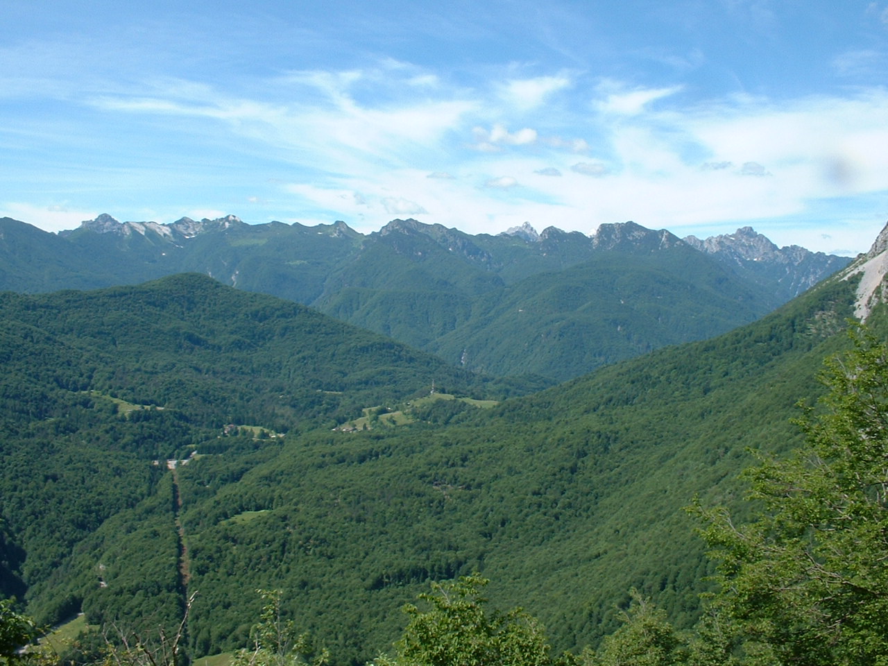
West toward Veneto


Southwest along the Friuli-Veneto border


Southwest- dolomite mountain


Deep gorge below the dam


Mountain to northwest above Lago di Sauris


Mountains to west and Lago di Sauris


Waterfall along the gorge


Friuli's answer to Bixby Bridge- Ponte Lumei


Lumei gorge from the bridge


Mountains above the gorge


Saturday, June 19, 2010

Pala Barzana - Collalto

Finally a pause in the rain this morning so I tried to ride this double climb. It starts with an ascent of 564 meters up to Pala Barzana (842 meters). It's easy and pleasant with beautifully forested mountain slopes. On the descent toward Barcis, I stopped by a little meadow where a flock of baby goats were playing. Very cute running up the rocky slope together, trying to butt heads like the big guys, then running back down to start the whole circle again. The descent ends below Lago di Barcis (400 meters), so you must ride through a 1 km tunnel to get there. Then you cross the dam, loop through a semi-circular tunnel, and cruise along the backside of the lake. After a couple of kilometers you reach the start of the climb to Piancavallo and Collalto.

It's a beautiful climb, along the rushing Torrente Caltea, in a thickly-forested gorge. The climb gains 950 meters in 16 km, up to Collalto at 1360 meters. Despite the effort, the nice cool weather made it very comfortable.

After the climb I donned my windjacket and descended on the gorgeous backroad to Castaldia. From there I joined the newly paved main road and flew down to Pedemonte (slowing more than usual for the tornanti because of wet pavement). Another 200 meters of climbing to home, for a total of 1776 meters.


Map of the climbs


Elevation Pala Barzana and Collalto


Thursday, June 17, 2010

Farra d'Alpago - il Cansiglio

 Another route to the altopiano del Cansiglio after a long ride from home. This one climbs from Farra d'Alpago, at 400 meters on the shore of Lago di Santa Croce, to Spert at 922 meters. The first 5 km climbs 450 meters, averaging 9.3%. After Spert (with a beautiful panorama of Lago di Santa Croce and the mountains of Belluno), the road dives down to a bridge over the Perosa, then climbs steeply back up to Campon, 1043 meters. All of this is engulfed in wonderful, dense forest. Not too long after Campon you arrive at the meadows of Pianosteria. From here to La Crosetta (1127 meters) lay wide green meadows, thick swathes of forest, all surrounded by a circle of mountains. It really is spectacular (pics here from ride in April) .

The descent to Sarone and climb home went well. Threatening black thunderheads never bore rain- just a light drizzle in the last kilometer in our hometown, the butt of many jokes about being the local rain magnet.


Map of the climb


Elevation of the ride


Grade from Farra d'Alpago (60 km) to Spert (66 km) and Campon (70 km)

Monday, June 14, 2010

Pala Barzana - Barcis

Rainy day- I was ready to go at 0900, but a rain shower blew over and put me on hold. At 1000 the sun popped back out so I jumped on the bike and took off. As I started up the Val Colvera I noticed the river was really full and churning. The water was chocolate milk brown from all the rain runoff. I enjoyed the roar as I climbed through the Bus di Colvera. At Poffabro I climbed up the tornanti and then continued to Pian delle Merie. A couple of Harleys rumbled by me, the only traffic I saw on the climb.

I climbed the two lower series of tornanti, only standing after the last switchback for a few hundred meters at 11%. At 600 meters there was a light rain, maybe condensing mist. It kept me nice and cool. All of the little streams were full of rainwater and quite noisy in the quiet of the fir forest. At the highpoint, 840 meters I didn't even stop, just got a drink and headed down toward Andreis. Descended slowly as there was much loose rock and debris in the road. At Barcis I turned right, through the 1 km tunnel to the bridge at the base of the lake. I thought about trying for Piancavallo, as originally intended before the rain delay, but I would have been late getting home and taking Marilyn to the store. I'll save the double climb for another day. I consoled myself with some exploring around Monte Dint and the Fora del Cellina- beautiful!


Saturday, June 12, 2010

Monte Rest da Priuso

I've ridden this route in the clockwise direction before, but had never tried it counterclockwise. I'd read the climb from the north is much harder than from the south, so thought I'd try it and see.

I remembered the Sella Chiampon road was closed last time I rode, so I figured I'd go over Sella Chianzutan instead. I rode up the tornanti at Anduins, up the beautiful Val d'Arzino and to the start of the climb to Sella Chianzutan. I overtook a guy who was going slow, and a fast guy passed me. Then at the turnoff for the road to Sella Chiampon, there was a barricade and some guys making everyone turn around.

Turns out today is the annual car race, a hill climb from Tolmezzo to Sella Chianzutan. They wouldn't let the fast guy pass unless he paid €8 to watch the race. I saw this and decided to try the closed road to Sella Chiampon. It was still messed up from the winter landslides, but passable. After awhile the fast guy caught up and asked me "dove vai?" I told him Monte Rest, and he took off like a rocket. I continued on the beautiful backroad, and was glad the race had closed the other road. This one avoids some towns and a longer drive on SS-52, a busy road with too many tourists, campers, etc. I was also glad to be doing the 20% grades downhill. Much easier.

After a short ride through Socchieve on SS-52, I turned off toward Monte Rest. There is a small climb first- Forcella Priuso. It's only 3 km long and gains 200 meters, with 6.5% average grade. Then you descend to a bridge across the Tagliamento. Now the climb up Monte Rest starts, 7.6 km with an elevation gain of 550 meters, averaging 7.2%. It was beautiful with many streams and waterfalls, switchbacks, a steady 8-11% grade, nice shady beech and fir trees, and fantastic views of the Tagliamento and surrounding mountains.

After a snack at the Passo, I headed down the tornanti to Tramonti. Then along the blue green lake to Meduno, and the flat ride home. I like the ride in this direction too- it seems two completely different rides.


Waterfalls on Arzino above San Francesco


Waterfall on Arzino above San Francesco


Wildflowers near Sella Chiampon


Wildflowers and chiesetta, Passo Chiampon


Waterfall along climb up Monte Rest


Waterfall on Rio Novarchis above Tramonti di Sopra


Map of climbs


Ride elevation

Thursday, June 10, 2010

Passo Mauria

Passo Mauria is a gap in the mountains dividing Friuli from Veneto. On the Friuli side, the Tagliamento River carries snowmelt and rain to its mouth on the Adriatic Sea, between Lignano and Bibione. On the Veneto side, the Piave River drains precipitation from the mountains to the Adriatic northeast of Venice. An excellent road connects the two regions here, wide and well-paved, and the gorgeous scenery makes it a popular cycling and motorcycling route.

I originally intended to ride from Ampezzo to the pass today, but the town was crowded and I couldn't find a place to park. So I continued until I reached Cima Corso, a wetlands preserve at 868 meters. I parked in front of a restaurant and set off on the bike. I headed down hill toward Forni di Sotto and was troubled to find a 2200 meter-long tunnel. It wasn't on Via Michelin or Google maps, so I didn't bring a blinky light. Luckily it was very wide, well-lit and there was no problem with cars seeing me. I'll take the tail light along regardless what the map or guides say from now on.

Forni di Sotto is a pretty little town. Beautiful carved wooden balconies covered with flowers adorn many of the houses. From there I continued up to Forni di Sopra at 900 meters. It's a bigger town with ski slopes and lots of vacation apts.

The highway then becomes more of a mountain road. Traffic is lighter, the road is surrounded by fir trees, and the only sound is tumbling white water in the valley below. The grade is very easy- mostly 5-7% so no problem. High above you can see the ridge line separating Veneto from Friuli- lots of dolomite spires and jagged rock. Pretty wild-looking. The pass at 1298 meters is simply a level section of road, with a restaurant and a sign.

It was warm so I descended without donning my wind jacket. Lovely ride- maybe I'll do it again as part of a loop from Sauris or Pesaris via Pelos di Cadore.


Dolomite and ice on the Veneto-Friuli border


A jagged ridge between the two regions


Hard to believe this trickle turns into a mighty river,
carving mountains and transporting stone and sand to the sea


Waterfalls a bit further downstream


Ancient hay-drying barn at Forni di Sotto


Wildflowers near Cima Corso


Elevation

Monday, June 7, 2010

Pedemonte - Col Alto

I've ridden parts of this climb before, but never altogether. The bottom half, Pedemonte to Castaldia, I rode as part of Pedemonte - Piancavallo. The top half, I rode as part of Costa - Col Alto . This is definitely the tougher workout of the three- steeper and longer.

I've been trying to practice standing more when climbing, and certainly got an opportunity this morning. Long stretches of 11-13%, with brief bits of 15% thrown in, had me standing at least half the climb.

It was warm and humid until about 600 meters, then became pleasantly cool. Around 900 meters I entered the cloud mist, and this continued to the top. I'd hate to try this on a clear hot day in July or August.

After the turn off at Castaldia, the landscape was beautiful, green meadows, beech forest, white stone outcroppings, cloaked in clouds. I came round a bend and a beautiful eagle was perched on a dead tree trunk. He heard me and took off, flapping his wings until he vanished in the mist. After a brief stretch of 13% I arrived at the high point of 1346 meters. I rested a few minutes and put on my wind jacket.

Then a fast descent down the main road through Piancavallo all the way back to Pedemonte . The road was practically deserted, though I saw a couple of bikes climbing up, and passed one guy going downhill. I wasn't pedaling, so no idea why I was going faster than him. Maybe he was clutching his brake levers all the way down.

At the bottom, I pedaled in silence, my hearing temporarily lost from the roar of the descent, and headed up the 200 meter climb home.


Graph of the gradient from Pedemonte to Col Alto


Saturday, June 5, 2010

Monte Pizzoc

This is really two climbs, stacked one atop the other. The first climbs from Vittorio Veneto to Passo La Crosetta at 1118 meters, a 17 km ascent at average grade 5.8%. Then a kilometer from La Crosetta starts the second climb to Monte Pizzoc at 1536 meters, up 6.5 kilometers of average 6.7% grade.

To start, I rode down Via Pedemontane Occidentale until Caneva, then the back way to Sarmede. There is a short steep climb from Sarmede to Rugolo averaging 11%, then a gradual ascent up to Fregona. It's a beautiful cliffside road. At Osigo it joins the main road from Vittorio Veneto to Il Cansiglio. This is a wide well-paved road, with nice tornanti and only one 0.5 km stretch of 11% average grade.

Toward the end the road is engulfed in beautiful forest. It briefly joins the main road coming up from Sarone, then arrives at La Crosetta. I coasted from here down to the turn-off for Monte Pizzoc. This climb starts with a steep couple of kilometers at average 7.8%. The road is narrow with frequently broken pavement. The surrounding forest looks different here- the beech trees are larger and farther apart than down near La Crosettta.

After a nice middle section of 6%, the road goes back to 10% and exits the forest onto a grassy bald mountain. Low flying clouds were billowing around the rolling grassy knolls. A big flock of sheep and goats accompanied by asini were on the left side, enjoying lunch in the cloud bank. Further up, a family of beautiful horses wearing bells were enjoying their unfenced pastureland. One foal was drinking her mother's milk, another was gamboling around. I continued to the top, which was completely socked-in. I'll have to climb this mountain again on a clear day- I've read the views are awesome.

Now I descended all the way down past Sarone to Via Pedemonte. Then another 25 kilometers with 300 meters of climbing home.


The horses in the clouds

Two foals on Monte Pizzoc


Beautiful horse with bell atop Monte Pizzoc


Map of the climbs


Elevation


Wednesday, June 2, 2010

Monte Ragogna da Muris

A steep short climb with great views and history. From a distance Monte Ragogna looks like a peaceful tree-covered standalone hill on the bank of the Tagliamento River. But on closer examination, it's a World War I fortress, a mountain honeycombed with tunnels, troop quarters, ordinance storage and large artillery emplacements. http://www.grandeguerra-ragogna.it/eng/storia.html

I climbed Monte Ragogna from Muris. It averages 10.7% for the first 2.2 km, with stretches of 16%. I started off standing, then climbed seated when the grade dropped to 11%. I alternated this way repeatedly as the steepness kept varying. The road is cloaked by forest, a lovely place. At the top is a ridge crest road, gently descending through the forest. There are a couple of openings with great views of San Daniele, the river, the towns on the opposite side of the river, and the plain. The road then descends steeply to San Pietro, and on toward home. It was an Italian holiday so no trucks and lots of bikes. Also a roller blade race in Montreale Valcellina- streets were all closed and dozens of racers took part.

The Monte Ragona climb from Muris is also part of Italian cycling history. According to Passi e Valli in Bicicletta- Friuli, in 1991 this climb saw the splendid rise of Gianni Bugno, who in the steepest stretch, opened a gap on Giro d'Italia winner Franco Chiocciolo, Claudio Chiappucci, and Moreno Argentin, arriving at San Daniele to be crowned Italian national champion.


Castello di Ragogna


Castelnovo del Friuli


Pinzano


Tagliamento River


Entrance to WW I fortress within Monte Ragogna


Restored section of castello di Ragogna


Map (climbed counterclockwise)


The gradient of the climb

Monday, May 31, 2010

Monte Valinis da Campone

Another mountain goat climb- the first 2.5 km averages 10%, with bits of 16%. To complicate matters, the road has much loose stone, fallen branches, and had rained the day before, so loss of traction was continuous. Great training because the feedback is instantaneous- you either correct your position or you fall.

I climbed most of this standing- it seems easier as long as I remember to pull back on the bars parallel to the slope. It really didn't seem too bad. At 660 meters you join the road coming up from Meduno (see Monte Valinis ). This road is a steady 9-10%, and climbs up through the forest to 900 meters. Then there is a cattle gate so you must dismount. Shortly after, the road turns to rough gravel and stone so you wobble along trying to avoid the bigger rocks and trying to maintain traction. Soon you are in a hilltop pasture with cows, and further still the stoney road ends at 990 meters. There is a wooden ramp here where paragliders leap off into the abyss. But not today- the windsocks were all horizontal, with gusts at the summit so strong I had to get low on the ground to avoid being blown away.

I decided not to don my windjacket up here for fear it would get blown to Treviso while trying to put an arm through a sleeve. So I wobbled down the gravel road to the cattle gate, and put it on there. I went pretty slowly downhill, except for the occasional stretch with a long view ahead. At Meduno I joined the main road and headed home. The wind was quite strong so the usually easy ride was a struggle.


Elevation of the climb


Map of the climb


Friday, May 28, 2010

Avasinis - Cuel di Forchia


This climb was included in stage 18 of the 2006 Giro d'Italia. It starts in Avasinis, a frazione of Trasaghis near Lago Cavazzo. The approach is very flat and easy, making all the more startling the sudden tilt upward to 14% for the first 400 meters of tornantini. I stood to climb this section, and was glad I did. After 400 meters the climb eases to a mere 11% briefly, then ramps to 16% for a few hundred more meters.

The next stretch through beautiful forest averages around 8-9% for several kilometers. It's very shady and quiet. But my revery was soon interrupted by another 250 meter ramp of 18%. The pavement was damp from the clouds, and every 50 meters or so smooth metal rain channels cross the road, so traction was a problem. But I finally made it to the lovely open area at the top of the climb. It was cloudy so views of surrounding mountains and Lago di Cavazzo were obscured, but it was still beautiful. The road then drops down about 50 meters and climbs to the actual pass, Cuel di Forchia, which separates Monte Cuar from Monte Covria.

From here the road hugs the side of a ridge until finally reaching Val Tochel. Here is a crossroads- the right descends to Val d'Arzino, the left descends to Monte Prat and Forgaria (the 2006 Giro stage route). I rested here awhile and enjoyed the singing birds, frogs, etc (there is a little marsh with cattails up here at 900 meters). Peaceful spot.

Mountains to north


Looking back at the pass: Monte Cuar on the left, Monte Covria on the right


Murale for Giro on tornanti above Forgaria


Nice bike


More of the murale


Map of the climb


The gradient

Wednesday, May 26, 2010

Monte Prat - Orton - Campone

This ride is a chain of climbs I've done before, but never all in the the same day. Together they include 1666 meters of climbing in a 40 km stretch. It was quite overcast and threatened to rain, so I didn't take the camera. Luckily I made it home without getting soaked.

The first, Monte Prat, is a long moderate climb with beautiful views of Fiume Tagliamento, Monte Ragogna, San Daniele, Monte Chiampon (see pictures here http://dolomiti-friulane.blogspot.com/2010/04/orton-monte-prat.html ). It starts with a series of steep tornanti from Val d'Arzino up to Forgaria. After Forgaria there's a steep climb out, then continues less-steeply to San Rocco. After San Rocco it steepens again and climbs a series of tornanti to Monte Prat, a lovely rolling meadow. Here the narrow road enters a pretty forest, with an easy climb up to Val Tochel, 894 meters. I took a break here, enjoyed the view of the meadow and the east peak of Monte Cuar looming overhead. Then down the long descent through pine-covered mountain slopes to Val d'Arzino (350 meters).

Here the second climb starts, my favorite section of the ride. The road from Pielungo to Orton (699 meters) is cloaked in a dense canopy of beech trees, so thick I had to take off my sunglasses to see. It is silent except for birds singing and falling water. The climb continues until Forno, where it descends briefly through meadows with sheep and cows, then the road points upward again. At Orton I headed down through the beech forest to Gerchia (Pradis di Sotto) at 535 meters.

Here begins a very moderate climb to Piani di Clauzetto (675 meters). The first stretch passes through beautiful karst formations near Grotto Verde. Then a long straight road to the little pass. Then the lovely descent along Torrente Chiarzò to Campone and on to Lago di Tramonti (nice pics here http://www.montanevie.it/index.php?id=10&L=1 ).


Elevation Monte Prat, Orton, Piani di Clauzetto


Climb from Forgaria to Monte Prat


Climb from Val d'Arzino to Orton


From Gerchia to I Piani di Clauzetto and Campone