Friday, October 29, 2010

Monte Rest out & back

Today's the last day of sunshine for awhile, so I headed up Passo Monte Rest.  I was a little worried the pass might be snowed-over because it's over 1000 meters, but I figured I could just turn around if the road was closed.

I headed to Meduno, then Tramonti di Sopra where the climb begins.  It climbs gradually at first, until the Ponte di Torrente Viellia at 492m.  From here to the top you traverse 26 switchbacks, gaining 560 meters in 8 km.  The surroundings are beautiful- beech tree forest with orange and yellow leaves dappled with sunlight, mixed with dark green conifers.  All the rain has the streams running like crazy, with gorgeous waterfalls where the switchbacks repeatedly cross Torrente Viellia.  The sound of birdsong and falling water accompany you all the way up the climb.

After the road crosses this torrente for the last time, through a gap in the trees there's an awesome panorama of the valley and surrounding mountains, with the twisty road you've climbed visible far far below.  The cliffs of Monte Rest rise hundreds of meters vertically above you.  Around 900m snow appears on the road sides, though much has melted from the southern exposure's  bright sun.  Above 1000m the snow covers everything- just before the top you enter the shade of an adjacent peak, which has prevented the snow from melting.  It weighs down the boughs of tall conifers, with occasional loud crashes of a limb's snow-load impacting the ground far below. 

After donning my wind jacket I headed back down.  I slowed to a snail's pace at the end of each tornante because of ice and wet leaves, stopping several times to enjoy the music of waterfalls.  On reaching the bottom I rode home as rapidly as possible to check on the dogs. 


Thursday, October 28, 2010

Pala Barzana - Orton

After a week of rain I was eager to hit the road on this sunny morning.  Unfortunately while it was raining down here, it was snowing in the mountains,  and I read it was accumulating down as low as 800 meters.  So I decided to stay low, and do a series of medium/small climbs rather than one tall peak.

It was quite chilly out, but nice and warm inside the 4 km tunnel to Barcis.  I headed up the hill toward Pala Barzana.  They've patched up the worst parts of the road, including a one-foot vertical slump above Bosplans- that used to be a pain.  Luckily there was no snow all the way to 855 meters.  The views of snowy Monte Raut directly above me, and the mountain range above the west escarpment of Val Cellina were glorious.

I descended the curvy road toward Poffabro more slowly than usual- lots of damp leaves in the curves.  The streams and torrenti were churning with white water- quite noisy.

After Poffabro I descended down Val Muié to Navarrons, and then crossed the Meduna.  Saw 3 eagles along this road, a large one only 20 meters or so away. After Lago di Tramonti I turned right on the road toward Campone.  This road climbs through the lovely gorge of Torrente Chiarzò for maybe 10km- very peaceful place.  After a bit of climbing you reach Piani di Clauzetto at 675 meters.

Then a short fast descent to Pradis di Sotto and the climb to Orton begins- tornanti through dense beech tree forest, engulfed in orange leaves backlit by brilliant sunlight.  At Orton are open meadows with spectacular views of snowy mountains to the north and west.  Directly above stands Monte Pala, covered with fir trees.  The actual high point on this climb is at Cristo- 723 meters.

From there a steep descent to Clauzetto.  The road through town was closed for repair, so I headed down the fast sweeping tornanti to Vito d'Asio.  Shortly after I turned on the small road to Celante.  This is a very narrow road, rough, covered with leaves, branches etc.  But it's heavily forested, and not too steep.  Riding through here I remembered Marilyn and I taking Sunday afternoon walks with our terrier Rocky on these roads when we lived in Castelnuovo ('94-'96).  Good times.

This little lane eventually joined the curvy main road below Clauzetto to Travesio.  Torrente Cosa was roaring with rain runoff.

Now on the flats I bore down and rode as fast as I could all the way home- the pups were waiting for my return!

This is a great ride, with possible variations.  You could add Meduno- Monte Valinis-Campone in the middle, or Monte Prat at the end.

Elevation

Pala Barzana to Lago di Tramonti


Piani di Clauzetto-Orton


Thursday, October 21, 2010

Nevegal-Monte Faverghera da Belluno

I was delighted to read on Italian Cycling Journal that the 2011 Giro d'Italia will include a climbing time trial from Belluno to Nevegal.  Can't wait to see the racers speeding up this steep grade against the clock.  To celebrate the news, I decided to ride the course.

Last month I rode from Lago Santa Croce to Nevegal-Monte Faverghera.  Today I followed the same warm up from Vittorio Veneto up over Sella Fadalto to Lago Santa Croce.  But this time I continued through Ponte nelle Alpi to Belluno.

From here there is a nice climb up to Castion.  Shortly afterward the road shoots skyward, gaining 550 meters in 5.5km (about 10%), with stretches reaching 15%.  The terrain is beautiful dense forest, which looked great in Autumn gold.

After the steep bit, you reach grassy meadows and then Nevegal (1000m), a ski center.  The time trial in the Giro won't include it (as far as we know) but the road continues switchbacking through the forest to 1400 meters.  Beautiful views of the surrounding Dolomiti peaks on this crystal clear day.

Descended rapidly (and coldly) to Nevegal, then headed down the route I rode last month to Vich and Lago Santa Croce.  It has some awesome long steep straight stretches which are a blast.  Just keep your eyes peeled because the hairpins arrive very suddenly!

After skirting the flat lakeside, I climbed briefly to Sella Fadalto, then another fast curvy descent to Vittorio Veneto.  Awesome ride!  Should be a great Giro stage.


The gradient from Belluno to Monte Faverghera


Tuesday, October 19, 2010

Foothilly ride


Sun popped out today after a few days of rain.  The mountains out back are capped with snow.  So I decided I should stay at low elevation to avoid the snow and ice.

Headed down Via Pedemontane to Sarone, then turned and climbed up to Castello di Caneva.

After descending to Caneva, I headed up past Castello di Cordignano at Villa di Villa.  Very steep little road up over the hill to Rugolo (15% stretches).  I continued along this hillside road through Montaner to Fregona.

I descended steeply from Fregona to Vittorio Veneto, then found the start of the forested climb to San Lorenzo.  Beautiful fall foliage!  After the summit I turned toward Tarzo, on the hillside above the valley stretching from Vittorio Veneto to Valdobbiadene.

I then crossed over the ridge above Conegliano and descended to Vittorio Veneto.  Lovely views from that ridge.

I rode fast along the flat road to Fiaschetta, and then climbed the rolling hills up to 300 meter altitude and home.  Total 105km and 1367 meters of climbing.

The hilly profile


Friday, October 15, 2010

Passo San Boldo da Tovena

I've been sick with a cold or flu all week, but now my fever broke, it's beautiful out and it's time to ride.

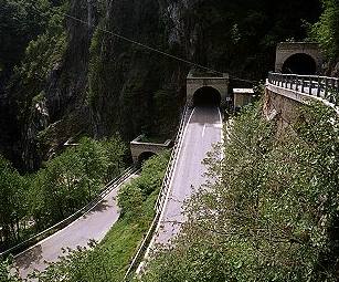
This climb starts off the road from Vittorio Veneto to Valdobbiadine.  It climbs gently through a beautiful little green valley for a few kilometers, then starts the first of 18 tornanti up the forested slope.  Then at tornanti 6 you reach a near vertical cliff wall at the head of the valley.  The next 5 tornanti are directly on the cliff face, with the u-turn at the end of each one inside a u-shaped tunnel.  It's a remarkable piece of engineering, and they manage to keep the gradient down in the 10-12% range all the way up.  Marilyn has my camera in the States, but you can see a picture of the scala here:
http://www.magicoveneto.it/Trevisan/CisonValmarino/Strada-Passo-San-Boldo_F01.jpg

After the pass (706 meters) I descended on the easy side to Trichiana.  Here you join the main road from Belluno to Feltre- a bit too busy for my taste.  At a traffic jam by Belluno I said to heck with it and headed up the road toward Nevegal.  I was hoping some of these little country roads would connect to the descent to Lago Santa Croce.  I climbed up past Castion, Caleipo and Sossai to 570 meters but the road eventually turned to dirt and got too steep, so I turned around.  By now the traffic jam was gone so I continued down the main road.  I skirted Lago Santa Croce, climbed up to 500 meters at Passo Fadalto, and descended rapidly to Vittorio Veneto.

Great ride- I'll try it in the opposite direction next time.

Saturday, October 9, 2010

Monte Cesen da Combai

Beautiful sunny Autumn day.  I returned to Monte Cesens this week to try a different approach- the climb from Combai to Casere Budui.

As before, I warmed up with a ride from Vittorio Veneto, through Revine Lago to Combai.  It's gently rolling most of the way, but climbs pretty steeply up to 430 meters at Combai.  The town was hosting a Sagra Marroni or chestnut festival.  The woods are full of chestnut trees here and folks are all over the forest with baskets to stash their gathered chestnuts.

I  descended slightly and then the main climb began.  The road looks good at first, rising steadily through dense chestnut and fir tree forest.  Chestnuts were literally raining down at some points, striking my bike and the pavement around me.  Soon the pavement becomes very rough, with many washed-out areas, craters etc.  I'm guessing the drainage isn't good so it becomes a torrent in heavy rains.  This undermines the roadbed, tears away chunks of asphalt, and so on.  It wasn't too bad on the climb up, because I was pedaling so slowly (due to the steep gradient) that it was easy to choose the best line.

The road through the dense forest continues steeply upward, repeatedly exceeding 12% on the long tornanti.  My back was aching from the climb up Cason di Lanza a couple days ago, but standing didn't feel much better.  The average grade is 8.2% for 10km, which includes several false flats.

Around 1000 meters the road popped out into open pastureland.  It was hazy so the panorama was obscured, but the view of Monte Cesens above was wonderful.  A beautiful eagle leapt from a branch, did a sharp 180 degree turn a few meters above my head, and glided out into the great blue.  The climb continued up to Casere Budui at 1200 meters, where some folks were eating.

I put on my jacket and headed down.  Because of the horrible pavement I spent most of the time clutching the brakes, balancing on the pedals.  Next time I will traverse the flank of Monte Cesens to Pianezze, and descend via the much better road to Valbiaddene.

I was frozen from not pedaling on the descent when I arrived at Combai, so pedaled as fast as possible to warm up.  The descent on the main road was steep and fast with great curves.  I continued going fast on the long gently rolling stretch down to Vittorio Veneto- very fun.

Note: I don't have any pictures- Marilyn has already packed the camera for a trip back to the States next week.

The gradient

Thursday, October 7, 2010

Passo Cason di Lanza da Pontebba


The climb from Pontebba to Passo Cason di Lanza is a mystery- I've read it's unrideable on a road bike, the road is closed, etc.   But that's out of date information- it's very rideable, but be ready- it's steep!

I got a late start- the front tire was flat (I checked it a few days ago and it was fine).  So with the long drive to Moggio,  I didn't start riding until 1115.  I planned to ride up the main highway SS13 to Pontebba, climb to the passo, then return to Moggio via Sella Cereschiatis.  The ride up SS13 was great- perfectly paved wide road, with a gentle upgrade along Fiume Fella through beautiful mountains.  Traffic is light because most vehicles use the autostrada.

At Pontebba the climb proper begins.  It's a wolf in sheep's clothing- starts out as a lovely lane through green meadows along Torrente Pontebba, with rustic mountain houses, waterfalls, surrounded by mountains.  The road eventually gets a bit steeper and climbs along the side of the gorge above the white water.  At around 900 meters, everything changes.  A series of long twisting tornanti, many in excess of 20%, carry the road steeply up to 1400 meters.  It was one of the toughest climbs I've done- standing in the pedals trying to breathe deeply enough to continue, the only chance to sit and catch my breath at the next 180-degree turn.  The surrounding forest is dense larch, fir, and some colorful Autumn hardwood trees.  The only sound is the white water far below in the gorge.  To add to the difficulty, there are metal drainage grates across the road every few hundreds meters.  For each, you must angle your approach to avoid having a tire fall through the grate.  Worse still, the metal is damp from the clouds and mist, so the rear wheel slips, disrupting your momentum and threatening to send you tumbling.  The gradient finally lessens a bit in the meadows surrounding Casarotta around 1400 meters.  Then comes the final push at 10-13% on broken pavement up to the pass at 1560 meters.

I stopped briefly and quickly got quite cold, so donned my Windtex jacket and headed down.  I descended cautiously because of the grates, several very bad slumps of the roadbed (6-8 inch vertical drops all the way across the road), small streams crossing the pavement, and a large rock landslide that's had a narrow path plowed through it, but is still very rough.  Other than these the pavement is quite good except near the summit.

At Pontebba I noted the time (1415) and cancelled the climb over Sella Cereschiatis.  Instead I rode as fast as I could down SS13 to Moggio, arriving 45 minutes later.  Felt great cruising down that steady grade.

If you get a chance, ride this.  The scenery is wonderful and the over-20% stretches are a serious workout.  You won't be disappointed.

Waterfall down in the valley above Studena Bassa 

Another waterfall further up the valley

Looking up toward the pastures of Cason di Lanza (1100m)

Dolomite spires, meadows above the valley


Autumn colors above Casarotta (1400m) 

More Autumn color on the north side of the valley

The gradient showing 20% stretches

Saturday, October 2, 2010

Monte Cesen da Valdobbiadene

Another break in the rain, so I rode west from Vittorio Veneto to Valdobbiadene on the Strada di Prosecco, then climbed Monte Cesen (1500 meters).

I noticed a lot of signs marking the route of the Prosecco Cycling Classic granfondo tomorrow.  I was riding it in the opposite direction though- starting with gentle rolling hills until Cison, then growing steeper up and down.  The grade even hits 12%, reaching a 410m high point at Combai.  Here the countryside changes from a pretty valley between 2 parallel ridges, to hilly vineyards covered with prosecco vines.  The road snakes around and over these, before plummeting down to Valdobbiadene.  Hundreds of cyclists were streaming along the road.

The climb up to Monte Cesen starts in the piazza, which was crowded with people getting ready for the granfondo tomorrow.  Cherrypickers were hanging giant green fiberglass grappoli above the street like Christmas decorations.  Other workers were readying the platform and viewing stands for the presentations and ceremonies.

After working my way through this I found the little lane to the climb.  The initial wall, a kilometer of 10-11%, lays down the gauntlet.  For some reason I decided to do this seated; in fact I didn't stand at all till the very steep upper third of the climb.  I paid with a sore back, but maybe it will make me stronger.

After the wall, the road continues for 10 km at 7% average, in a series of long tornanti varying between 5-11%.  Until 750 meters the road is immersed in dense forest, then emerges into big grassy meadows with groves of smaller trees.  It reminded me a bit of Shenandoah or the balds in the Smokies.

At 1076 meters you reach Pianezze, a little settlement.  Now the steep upper third starts- gaining 400 meters in 4 km.  I had to stand for the long stretches of 12%.  The weather, until now partly cloudy and overcast, turned into a low lying cloud bank, very foggy.  I could hear cow bells but could see nothing but a patch of road.  Thankfully at the top there was a hole in the cloud and some sun peeped through.  There is a place to eat and sleep here, Rifugio Mariech.

I donned my cold weather gear and began the descent, riding slowly due to fog.  Below Pianezze the road dried a little and visibility improved.  The pavement is very good, though it has a grainy surface rather than silky smooth.  So I descended very rapidly for 10 km, though slowing for the 180 degree turns at the end of each tornante.  I was afraid of some loose peebles putting me down.

At Valdobbiadene I turned back toward the east.  The sun was a bit brighter through the haze, making the vineyards especially beautiful.  I stayed on the big ring on all but the steepest climb up to Combai.  My legs and back were sore but felt strong.  30 km later I reached Vittorio Veneto.  One of those perfect rides that wears you out but you have fun doing it.

Santo Stefano above Valdobbiadene


Prosecco vineyards

Meadows above Pianezze

From the top looking north toward the dolomiti

Milk cow perched on a very steep slope 


Thursday, September 30, 2010

Nevegal - Monte Faverghera

After a week of rain, finally blue sky and sun have returned.  My first ride of Autumn will be from Vittorio Veneto up to Lago Santa Croce, then up to Nevegal (1050 meters) and Monte Faverghera (1435 meters).

The warm-up climb from Vittorio Veneto to Lago Sante Croce was quite chilly- the gorge between Monte Pizzoc and Monte Faverghera is like a big funnel compressing all the winds from Cadore through a narrow gap- very breezy.  The gorge is in the shadow of Monte Pizzoc as well, so no warming sun.  But a few kilometers of climbing warmed things up.  Most of the traffic uses the adjacent autostrada, so it's a peaceful little climb.  Far above to the west I could see the antennas atop Monte Faverghera, my destination.

The lake was beautiful as always with reflections of surrounding mountains and clouds.

Just after La Secca north of the lake I turned left and headed upward.  There are a couple of very short steep ramps- one hitting 20%.  After that I stopped and stripped off all my arm and leg warmers and Windtex jacket.  Found room for it all somehow in my jersey pockets.  After a flat spot at Vich the road tilts upward again until joining the strada provinciale from Ponte nelle Alpi.  Most climbing websites and guidebooks start the climb at Cadola in Ponte nelle Alpi, but I shaved a few km off the ride by going through Vich.

This is a wonderful road with good pavement, steadily upward but not too steep, bypassing the center of all the little villages.  There are plenty of curves but also 2 very long straight stretches with a steady gradient.  The landscape is a mix of pastureland and forest, with beautiful views of the bowl of Alpago and mountains above Belluno.

At Nevegal, a ski area, the road changes into a narrower climb through heavy forest.  The pavement is still good, with lots of curves and tornanti.  At 1400 meters the road ends at a casera.  I almost turned around here, but noticed a "paved" path up toward the  Giardino Botanico di Monte Faverghera, a 60,000 hectare reserve.  The path up from the casera is chunks of rock embedded in concrete, with a 20% grade.  I got a running start and cruised up this, trying to avoid the pointier rocks.  When it turned into a dirt road I stopped and hiked up to a a high spot on the cliff above Lago Sante Croce, 1000 meters below.  Watched an eagle hundreds of meters below circling around the cliff face.

After rolling down the rock path with brakes squeezed tight, I started the descent.  I startled a deer eating on the verge, who scampered up slope into the forest.  Then down down down, round one curve after another.  On one long straight stretch I heard a loud clicking so stopped. The speedometer magnet had slipped down its double butted spoke onto the narrow middle, and rotated, striking the pickup sensor.  While I was tightening it a guy climbing the opposite direction offered help "Ha un guasto?"  Nice to know there are people willing to help if anything goes wrong out in the middle of nowhere.

Finally this descent ended at the lake shore.  After a flat bit, and a short climb up Sella Fadalto, the fast easy descent down to Vittorio Veneto, with more swooping curves.

I drove home and my neighbor's firewood delivery had arrived, so helped with the stacking.  Then we had caffe' and gelato.  It was a wonderful day.


Dolomiti above Belluno

Tre Cime di Lavaredo

Lago Santa Croce with cloud reflection

Malga Mezzomiglio

Tambre with Monte Cavallo in background

Monte Pizzoc above Fadalto

The rocks-in-concrete 20% path to 1435 meters

One way to keep outsiders away- name your village Pus

Cugnan with Monte Dolada in background

Map of the climb

Gradient

Elevation


Tuesday, September 21, 2010

Barcis - Col Alto

Did a bit of work on the bike yesterday.  Took the tire off rear rim because it had a hole in the sidewall and the tube was beginning to extrude through it, so I booted it with a piece of tough plastic wrapper.  Also the new rim had a burr where the rock at Passo Pura struck it.  So I sanded that flat.  Also replaced plastic cleat on left shoe- it was getting pretty sloppy, clicking and clacking and squeaking.  For some reason my cleats don't wear the same on right and left shoes.

Today was absolutely gorgeous- no haze and not even a cloud over the mountains.  That is rare here.  But I couldn't ride this morning because I had some repairs around the house I promised to make.  Afterwards though I hit  the road.

I had to be home in 3 hours to feed the dogs, so I decided to ride up through the tunnel to Barcis, then around to the back of the lake and head up the road to Piancavallo (Col Alto actually).

The climb was beautiful- the gorge is covered in trees still full of green leaves and needles.  The sound of the torrente was very soothing.  A small deer ran across in front of me and down the slope.  The grade wasn't too bad, constantly varying between 7-13%, with elevation gain of 990 meters.

At Piancavallo I headed up to Col Alto, which has a beautiful alpine road down to Caldastia.   The views through the clear air were lovely, all the way to Slovenia.  At Caldastia I joined the main road, descending for miles on smooth pavement, exhilarating tornanti.

The remaining kilometers up the Via Pedemontane to home revealeded how tired my legs and back were.  I think they're still sore from Pian dei Grassi on Sunday.  But I still made it home in under 3 hours, so can't complain.


Sunday, September 19, 2010

Pian dei Grassi


La settimana della pioggia has finally ended and everyone was out riding today.  Hundreds.  Favorites were a little girl on a tiny bike riding next to her father- she was wobbling a little but doing great.  What a joyous feeling as a child....  Another was an infant taking a nap on father's shoulder as he pedaled along the bike lane.  Cute.

I felt a little rusty and stiff at first but soldiered on.  I rode past a fellow at an intersection and he soon passed me and rode away on a 5% climb on Via Pedemontane.  I felt like I had no strength.  Later I passed him when he had stopped, then he caught up again and asked where I was going.  I told him above Vittorio Veneto, and he asked if I was taking the strada bassa o alta.  I laughed and said bassa.  No way I can ride up over Il Cansiglio (1118m) and then do the climb toward Col Visentin.  He said ciao and turned on the road for Il Cansiglio.

After Vittorio Veneto, I turned toward Valdobbiadene.  After a few hundred meters at Longhere (188m), I turned right, immediately hitting a short 10% ramp.  After a bit more climbing I hit the steep part- half a kilometer of 14-15%.  Good practice at breathing properly while standing on the pedals.  The grade mellows out a bit to 9-11% for several km.  After a couple of tiny settlements, Olivi and Menegon (640m), the  Ediciclo guide says the paved road ends.  But since the guidebook was written, the old dirt road has been widened and paved very nicely.

I didn't know how high the pavement continued.  The end of the road is Col Visentin (1763m)- was I going that far?  I decided to play it by ear and just keep climbing as best I could.  The grade was 9-13% but the nice road surface made up for it.  The new roadway is better than the lower portion of the climb, though it's more open to the sun, so at mid-day in summer it would be hot.  Luckily (?) a big cloudbank had rolled in so sun wasn't a problem.  I passed a place called Ca' Andrea, then continued on up to Pian dei Grassi, 1200 meters, where the pavement stopped.  The average grade for those last 5km is 10.6%   If you have a mountain bike, you can continue on to the 1763 meter summit.   There was a little paved road up to Casera Sonego, but I decided not to try it.  I can always come back and try later.

The descent is great- very smooth (for the top half).  Below Menegon the road is very rough and narrow, so I was holding my brakes the whole time.

The ride home was surprisingly easy.  Like last Tuesday's ride, it felt like I had a tailwind or was going downhill.  I think maybe the climb just makes the flats seem easier.

Note that Pian dei Grassi doesn't refer to grass but fat.  I'm guessing the fertile meadows produced fat sheep and goats?

Hay stacked around pole

Longhere sunlit by a hole in the clouds

Ca' Andrea with Monte Pizzoc in background.
Not sure why the Union Jack is flying next  to il tricolore

Vittorio Veneto


The gradient

Ride details