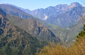
Instead, I continued down then back up to Monte Cereis (961 meters). The gravel road makes an interesting loop through the karst, sinkholes and trees. At the top is a grassy pasture with a heliport marked off.
I descended back the way I'd come, taking a break at Stalla Cereis, a stone house with great views of surrounding mountains and valleys. You can see Lago di Redona through the trees but I couldn't get a clear shot of it. Great ride!
 |
| From near Cavasso Nuovo: left Monte Chiarandeit, center Monte Mulon, right Monte Valinis |
 |
| Frisanco, Casasola, Monte Raut |
 |
| Chiesetta Alpini at Forchia di Meduno |
 |
| I took the left gravel road (to Monte Chiarandeit); the right ends at a settlement called Ferrara |
 |
| View of Chiarandeit from Stalla del Bianco (hunting cabin). It appears to be a big rock scramble with trees. |
 |
| From Cereis: Cavallo Group, Poffabro, Monte Raut |
 |
| View northwest |
 |
| Monte Celant |
 |
| Monte Raut. Last fall I hiked up to the notch you see below the snowcap, Forcella Capra |
 |
| From Stalla Cereis: Il Von (1147m) |
 |
| Stalla Cereis |
 |
| The road on cliffs above Torrente Silisia to Lago Ca'Selva |
 |
| Primula bouquet surviving in a shady spot |

No comments:
Post a Comment
Note: Only a member of this blog may post a comment.