I started from Kobarid, a few miles up the Soča River from Tolmin, warming-up on the road along the east bank. Just before you get to Tolmin take a left toward Zatolmin, and continue on the narrow farm road marked Hudičev Most (Devil's Bridge). You descend down near the edge of the Tolminka River gorge, where you can see tourist information, parking, trailheads, etc. Follow the narrow paved road along the gorge edge, with railings to keep you from taking a plunge. Through a very short tunnel and then you arrive at the bridge, very high above the water. Make sure you've downshifted because you're about to hit a wall.
The next half km averages 15%- I just stood and panted. Continue climbing to a 180 degree turn at the junction for Zadlaz, then climb the briefly-easier sun-exposed slope to Laz (423m). Here starts the steepest bit, which my Garmin recorded as 22%.
The remaining 3 km of climbing is a peculiar mix of 10-13% stretches punctuated with 15-20%
ramps to prevent you getting into rhythm. All told, from Devil's Bridge to Čadrg you average 9.4% gradient for 5.5 km. At Čadrg you pass by some farmhouses which I think rent rooms in summer. Very picturesque with bell-wearing cows, sheep, goats, pig wallows, chickens and ducks wandering about. The road finally ends in a farmyard at 741 meters, though you can continue on trails with a MTB.
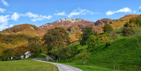
Fantastic views up here with surrounding mountains, autumn leaves, the gorge down to Tolminka River. I'll try to return next year on MTB and connect this ride with Tolminske Ravne and Planina Razor, some of the prettiest vistas I've found anywhere.
 |
| Veliki Stador (1899m) |
 |
| Grušnica (1570m) |
 |
| On left Visoč Vrh (1482m) |
 |
| Javor (1363m) |
 |
| Looking down Tolminka gorge toward Tolmin |
 |
| The view straight down from Devil's Bridge |

No comments:
Post a Comment
Note: Only a member of this blog may post a comment.