Pages

Tuesday, September 24, 2013

Cinque Torri

I'd always thought Cinque Torri above Cortina was reachable only by chair lift or hiking.  Then I saw an article about some tourists riding a bike up it so I had to go investigate.  I drove to Cortina very early then hopped on the road bike just as the sun was peeking above the mountains.  It was cold at 1200 meters but leg warmers and a wind jacket combined with the exertion of climbing kept me from freezing. 

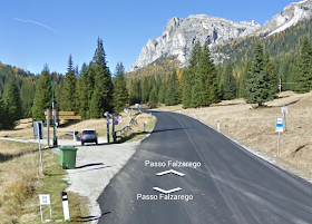
I ascended toward Passo Falzarego on the nearly deserted main highway.  What a difference from July-August,when the road is covered with diesel-belching motorhomes and tour buses almost too long to clear the switchbacks.  Soon I was up in the bright morning sun and I passed the turn  off for Passo Giau at Pecol.  A bit further up at 1724 meters I reached the left turn for Cinque Torri.

It's a narrow mountain lane, with barely room for the occasional car to pass a bike riding on the edge.  After dipping down to Rio Falzarego and a brief flat spot, you reach the climb.  This is one of the toughest little roads I've done: in the next 4 km you rise 412 meters.  No big deal you say, it averages 10%, but it does it with a relentless series of 15-18% grapplings, with brief dips down to mere 8-9% in between.  A had to stop and hyperventilate at least 4 times.  No matter how hard I inhaled-exhaled I couldn't seem to get enough oxygen to power my legs.  Once I stopped and got my gasping under control I could restart and pedal another 300-400 meters distance.  Finally made it to Rifugio Cinque Torri at 2137 meters and stopped to take some pictures.  A minivan full of French folks arrived, donned their gear and headed toward Torre Grande to do some climbing.  

I enjoyed the steep descent (pavement is good but watch for loose pebbles on the centerline) and the lovely switchbacks back down to Cortina.  This will be be a new benchmark for me to retry now and then.  Maybe next year I'll be able to cruise up non-stop.


Morning sun peeping into Cortina altopiano

Sun beaming through a notch in peak above Cortina

Turn left here for Cinque Torri


Tofana Group peaks

Tofana di Rozes (3225m)
Tofana di Rozes from higher up

Torre Grande

Alpine meadows toward il Giau

Monte Averau (2649m)


Sunday, September 22, 2013

Planina Zaprikraj MTB

A couple of years ago I reached the summit of Kolovrat and ogled the luscious Soča  River valley.  I noticed a beautiful church half way up a mountain above Kobarid and always have wanted to go visit.  Today was my chance.

I drove to Ponte San Quirino in Val Natisone and biked across the Slovenian border to Kobarid.  Immediately after you cross the Soča on Ponte di Napoleone turn left and head up hill.  This is a wide smooth road with well-engineered switchbacks for an easy gradient.  At 530 meters you reach the little town of Drežnica with its spectacular church, Sacro Cuore.  Somehow this escaped the artillery bombardments from both sides during World War I.  After crossing a forested ridge you enter a gorgeous grassy meadowland surrounding the village Drežniške Ravne around 600 meters.   Take a right onto the road marked Planina Predolina.

This is a narrow paved road and quite steep.  It reminded me of the road from cimitero di Mezzomonte to Col de Palse.  The difference being the pavement here ends at 700-800 meters, and you're climbing a dirt road.  Not too bad because any time the gradient gets up over 10% they've concreted the road so you have few traction problems.  When I say over 10% sometimes it's way over, like 16-17%.  I stayed seated on almost all of this thanks to the easy mountain bike gearing.

Finally around 1100 meters the dirt road levels out some.  You cross through a gate, then cruise downhill over a cattle grate near a farm.  A hiking path to the left goes to Krasji Vhr, 1773 meters.  The right road goes up and to the left above the farm, through a gate, then continues to Planina Zaprikraj around 1250 meters, and further down to Planina Predolina at 1190 meters. These are meadowy areas with many World War I ruins.  I saw a tunnel entrance and some very cool trench type fortifications.  They were a bit dark for my camera so please look at the professional pics at http://www.potimiruvposocju.si .

The ride back downhill was quite fun.  Disc brakes are excellent- maybe I'll get them on my next road bike (in the year 2020).  Kobarid was pretty crowded with tourists now but I eventually made it through there.  Then a good "cool down" on the road back through Val Natisone.  I want to return here soon and try some variations of this ride.


Sacro Cuore at Drežnica 

Close-up Sacro Cuore

Hay drying rack at Drežniške Ravne

Meadows around Drežniške Ravne

Looking back at  some of th grasslands I crossed on the climb,
with mountains across Soča River in background

Adorable baby asino at 1000 meters 

Friendly dark chocolate horse sharing her paddock with asini

High up the slope a flock of grazing sheep

The farm on the way to Planina Zaprikraj

Monte Krn (2244m) above on the right

Planina Predolina, with Monte Javoršček (1557m)

Cappelletto with musical staff showing the tune to the hymn


Friday, September 20, 2013

Casera Ceresera MTB

The ridge connecting Piancavallo and Il Cansiglio has several different trail routes.  Today I tried the trail to Candaglia via Casera Ceresera.

After climbing from Costa to Bornass I continued on the main road to Piancavallo.  Here I turned toward Sauc.  They've repaved the road and it's super smooth- big improvement.  Above Casera Campo the pavement ends and you continue on gravel.  It tops out just after Casera Valle Fritz at 1538 meters.  Shortly afterward you arrive at a side road to your right with a barrier.  I ducked under that and headed uphill.  The trail is basically two parallel tire tracks with tall grass.  Very pretty scenery with rolling rocky grassy knolls soon giving way to forest.  Karst stone outcrops everywhere with strange eroded shapes.

Eventually the road ends up in Il Cansiglio and descends along a mountainside covered with big trees.  The cloudy skies, shady forest, and coasting downhill soon have me freezing so I stop to put on my leg warmers.  Much better now and soon the stone house at Casera Ceresera comes into view.  You reach an information sign with map and turn right toward Motore Alpino which appears to be an old incline plane with winch.  There's a sign for Candaglia, but it turns out it's only a narrow foot trail traversing a steep slope.   I walked the bike on this because the steepness and narrowness were beyond my MTB skills.  A better rider might have no problem.  After a chilometer it joins the road to Candaglia and in a moment you arrive at the Casa Forestale.  Take the paved road to the right, and at the first switchback avoid the dirt road to Val Bona (and Val Menera), staying on the paved road.  Soon you reach the junction with a gravel road to your left marked La Crosetta.  This is a fantastic road, almost level (slightly descending), with smooth hard-packed surface and no big rocks or gullies.  It is immersed in a forest of big beech trees and spruce, sloping down toward Piancansiglio.  One hikers' picnic area had a sign marked Paradise and I had to agree.

Soon you reach the paved main road which carries you down the mountain to Sarone.  From there a good climb home on Via Pedemontane.  

Just past Casera Valle Fritz turn right

Looking back at the beautiful terrain traversed

Apparently I was riding through the forest on Trail 7 

The forest road descending toward Casera Ceresera

Casera Ceresera- head toward the right

I had to walk this, maybe you can ride it

Below Candaglia the turnoff for the wonderful road to La Crosetta


Tuesday, September 17, 2013

Piancavallo

I had big plans to wake up early and drive to Seren del Grappa  then ride to the mountain top.  But when I woke up the wind was howling and rain was pelting the windows horizontally.  In case it was a freak local cell I checked Monte Grappa's webcam and it showed windspeed of 63 kph.  That would pick me and the bike up and sweep us over a cliff.  So I waited a few hours till the storm quit, the sun came out, and I did a short local ride.  

Piancavallo is a great workout practically right out the backdoor.  There are folks at the airbase who ride it for their lunchtime fitness fix.  In fact today a young lady zoomed by me like I was a statue.  She came back down shortly after so I guess she did Rifugio Bornass and back, which is some of the steepest climbing on the hill

Anyway the storm blew all the haze away so there were great views of the Adriatic Sea to the south and snow-dusted peaks toward Slovenia.  Great ride! 

The bright band at land's end is the Adriatico

Got a little snow up high in the east

A beautiful wintery cloud forming


Saturday, September 14, 2013

Cima da Campo


I tried to do this climb last month but the area was rainy when I arrived, so I drove a  bit to the east and climbed Col Artent from Lentiai instead.  Today the weather was perfect.  I parked at Arsiè on the west bank of Torrente Cismon and warmed up on the riverside bike trail for Fonzaso.  Here I headed west on SS 50  to the tunnel Pedesalto.  This is too busy to ride through safely in my opinion, but luckily the old road along the river cliffs is still passable.  The road climbs above the gorge to an old dam where the water exits the lake in a large waterfall.  Pretty cool.  Now you turn left on SP40 ( which heads toward Roa and Lamon).  You're climbing a good gradient now, switchbacking past the turnoff for Arina and continuing up SP40.  Soon you enter Trentino province steadily climb upward until reaching 911 meters.  Afterwards you reach SP79 and turn left toward Castello Tesino (turning right takes you to Passo Brocon).

Castello Tesino is a pretty hillside town.  I saw the castle walls but did not stop to visit the site today.   I descended some and then began the 13km climb to Cima da Campo.  Rally cars kept driving by on this road, but there were also Fiats with folks going shopping mixed in.  The rally cars were going a bit faster than the regular traffic but not racing.  http://www.rallysanmartino.com/2013/percorso.htm  After crossing a beautiful altopiano I reached Cima da Campo at 1428 meters.  Suddenly there were signs stating the road was closed today for 3 different periods.  The officials told me to wait so I hung out for maybe half an hour.  Finally the the scopa (official car marking end of race) arrived, and they started letting cars descend.  Rather crowded with spectators and cars coming up the hill, but it was good because it slowed me down so I didn't flat on the terrible pavement.  Really torn up on the upper half of the climb from Arsiè.

Later it improved and I was able to loosen my death grip on the brakes a little.   This is a gorgeous area and some good climbing.  I think next time I'll try to ascend from Arina to Castello Tesino, which is supposed to be steeper, with 22 switchbacks and an unpaved section toward the end.  Sounds fun!


Cliffs above Torrente Cismon in morning fog

Wider view, including the Dover chalk-like cliffs closer to Arsiè

Waterfall of the dam at Ponte Serra

View of San Donato on Monte Coppolo (from Roa climb) 

View down Val Cismon from Roa climb

Church at Castello Tesino

Altopiano between Castello Tesino and Cima da Campo

Shepherds and dogs herd their flock across the altopiano

One of the rally cars

View to northeast from Cima da Campo

View to north

Looking back toward the climb from Castello Tesino

Pale di San Martino Group in the distance

View of Malga Celado on descent 


Sunday, September 8, 2013

Landri Scur e Landri Viert MTB


I heard about these caves above Maniago and had to go see them.  It’s a quick ride from our house past Maniago to Busa del Colvera on the mountain bike.  Several groups of climbers were scaling the vertical walls of the gorge this morning.  I crossed the main road at the bridge between the tunnels and then continued along the gorge until I reached a gravel road turning off to the left.  This descends to Torrente Colvera, and then continues to the left where the river splits.  Easy woodland road for awhile, then heads up a bit with some concrete sections around 12-13%.  

You arrive at Landri Scur and follow a trail to the left.  Here are several cave openings (blocked with iron grates today) in a beautiful zone of ferns and mosses.
Then you continue on to Landri Viert, with another short steep hiking trail where you can  view the large cave opening.

I intended to follow a trail to Val di Frina or Buffui on the Pala Barzana road but couldn’t find it.  So I returned to the main road and turned up through Val di Frina.  No signs but I saw a couple of left turning dirt roads that might connect to the trail- have to explore later.  Then on the Pala Barzana road I found the other trail.  That looked pretty steep- definitely be pushing the bike up that gradient.

Pala Barzana climb and descent were fun as always.  At the recreation area along Torrente Alba below Andreis a big crowd was picnic-ing, playing, enjoying the last few weekends of summer.   Great ride!  
  
http://www.uspcaipordenone.org/sito/index.php?option=com_phocagallery&view=category&id=10:raffaele&Itemid=175

Take the gravel road down hill to the left

Landri Scur cave opening is the dark area (locked with grate for safety)

To the right another opening

Another, maybe 50 meters northeast

Up above a rock formation with even more holes

This was 50 meters to the west.

Reminds me of Natural Bridge Virginia, which
was on the way to grandmother's house in NJ
Landri Viert from above, with 2 much larger cave openings 
A close up of the right Landi Viert cave opening

Close up of the left Landri Viert cave opening

On Pala Barzana road the trailhead at Buffui