Tuesday, April 26, 2011

Monte Dolada 2011

Monte Dolada (1939m) towers over the north end of Lago di Santa Croce and the northwest corner of Alpago valley.  At 1495m, Rifugio Dolomieu lies near the top of the forested section- above that lies the mountain's exposed dolomite peak.  The views from the rifugio are spectacular- it really feels like you're flying, looking down at the earth.  

I started driving at 0715 under heavy overcast sky and rain showers.  But a few kilometers west it started clearing and by the time I reached the parking spot north of Vittorio Veneto it was sunny and mostly clear (146m).  It was quite cool and very windy in the gorge, as usual.

After the easy climb up to Sella di Fadalto (487m), I cruised along the west shore of Lago di Santa Croce until the right turnoff for Paludi.  Soon the road turns upward, with a series of easy tornanti carrying you up to Tignes (560m).   Continuing upward to Pieve d'Alpago (690m), the climb begins to steepen.  I tried remaining seated for the most part to save energy for the bigger climb ahead.

Reaching Plois (850m), the real climb begins.  Coming out of town is a half kilometer stretch averaging 15%, with bits of +18%.  This "eases" to 12% average for the next half kilometer.  Now comes a nice flattish spot at La Carota ristorante, where you can catch your breath and stretch while riding.  The road from San Martino di Chies d'Alpago arrives from the right, then immediately you hit the hardest section-  2.25 kilometers averaging 13.5%.  In this section there are 2 or 3 very long straight stretches, with no chance to catch your breath.  I rode this standing  At least the pavement isn't bad, and the drainage channels have been asphalted so they only have a slight dip.  But today this section was covered in tiny flowers from the surrounding trees.  The flowers and dampness caused some traction problems when standing.  After this challenging bit, the average grade eases to slightly above 10% for the final kilometer and a half.

The end of the road at 1495m is covered in beautiful fir trees, with the rocky promontory of Monte Dolada visible overhead.  Through gaps in the trees there are inspiring views of the conch of Alpago, the Lago, surrounding mountains.  But today low flying clouds were heading in, in one case completely obscuring the view of the lake within seconds while I fiddled with my camera.

I headed down carefully, but tried to make time on the straight stretches.  It was a challenge to slow down at the ends while jumping drainage channels, and braking hard on a damp road covered with little flowers.  At one switchback I encountered a mountain biker ascending- the only human I saw above Plois (I did see a deer on the ascent).  Shortly after, I was flying down a straight stretch and apparently hit a rock, blowing my front tire tube.  I changed it by the road and continued the plummet.

After Plois the road is much better and you can descend rapidly.  When I reached the lakeshore, the wind had reversed direction from this morning, and was in my face again.  Cruel fate.

This is a great climb and I'll try to tackle it again this summer.

Alpago forest and meadows

Epiphtye (or moss?) growing on tree at 1495m

Lamosano and Torres far below

Chies d'Alpago

Map of the climb

Detail of Plois to Rifigio Dolomieu

Detail Tignes to Plois

The long, steep section above La Carota- 2.27km averaging 13.5%

The gradient from Pieve d'Alpago to La Carota;
note the 18.5% climb out of Plois 

From La Carota to Rifugio Dolomieu (1495m)


Saturday, April 23, 2011

Fuessa - Val di Lauco

This is 2 climbs grafted together, with lots of ups and downs, and beautiful scenery along the way.  I drove to Tolmezzo and began pedaling toward Caneva.  I was a bit concerned that the steep climbing would start too soon into the ride without a  good warm up.  Not to worry- the turnoff for Caneva was marked "Austria, Sappada, Villa Santina" so I missed it and cruised around Tolmezzo for 15 minutes- short warm up but better than none.

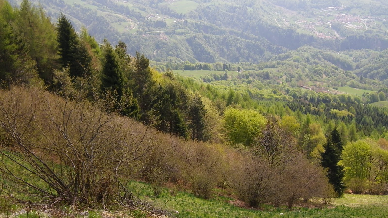
After crossing the bridge over Torrente But (320m), I turned right on SP21, through the tunnel and shortly after turned left onto the road for Fusea.  It heads steeply upward almost immediately, with a series of tornanti that had me standing pretty much the whole time (except for the bends at the ends).  After a long time I reached the rolling meadows at Fusea (700m)- still steep but the lovely scenery made it worthwhile.  Then, after a stretch of climbing through forest I entered another big meadowy area, Curiedi (920m).

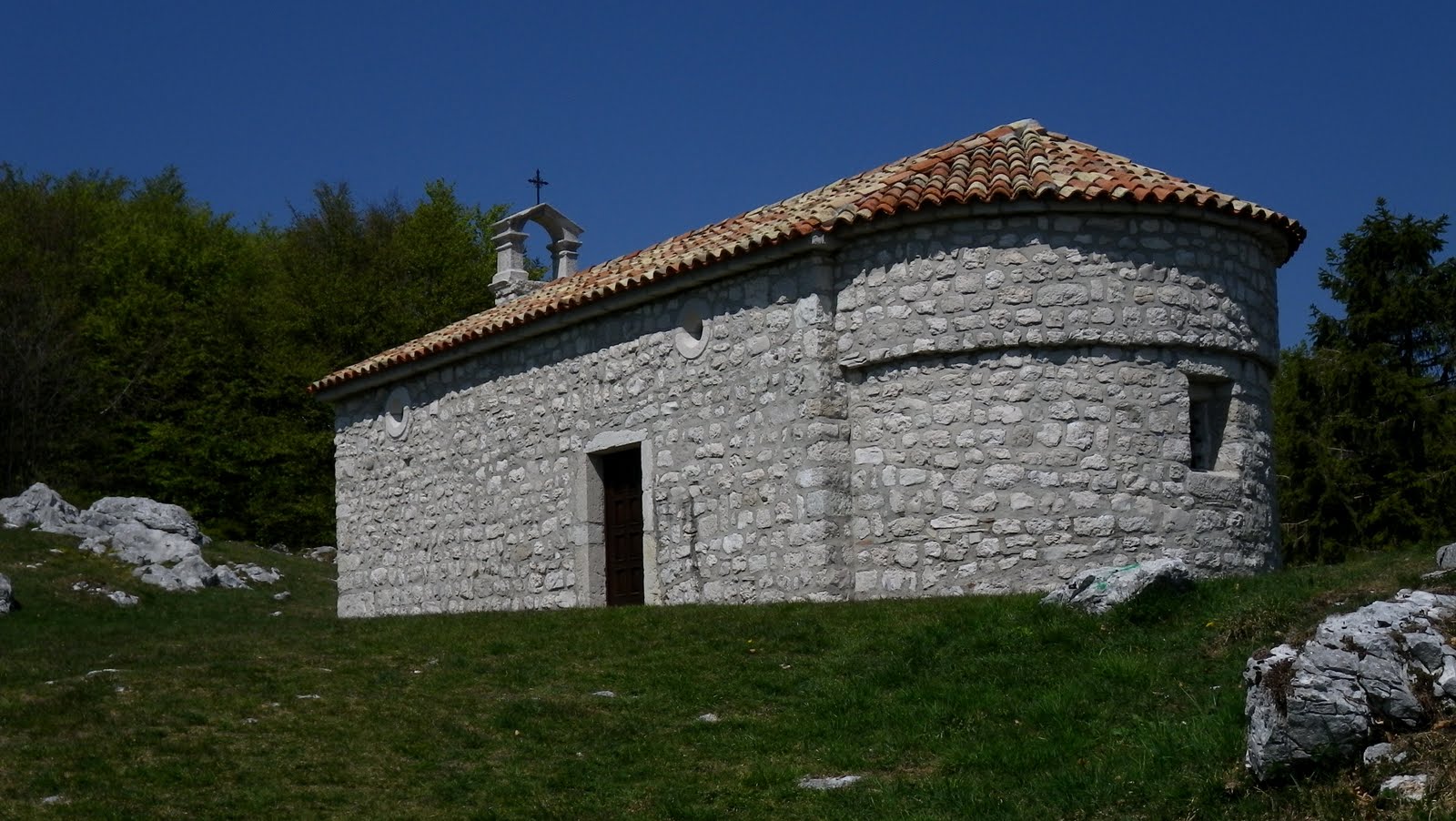
Now you turn left toward Buttea.  It's a steep descent along the sides of a seemingly bottomless gorge.  A man emerged onto the road having climbed up the side of this gorge with 2 black teruvians and a herd of goats.  And I thought I was working hard.  You eventually intersect Torrente Chiantone at 800m, and immediately head steeply up the opposite side of the gorge to Buttea (900m).  From here, a bit more climbing and you reach Fuessa (1012m), though the only sign I remember seeing in the place read Plugna.

Now you can either turn around the way you came, or you can head to Villa Santina via Vinaio.  I opted for the latter, which entails a descent to another mountain stream, Torrente Picone (775m), and then the little climb up to Vinaio (820m), with lovely Austrian-style wooden balconeys/flowers.  Here it's decision time again- ride down to Villa Santina, or climb the 350m elevation gain of average 10% grade to Val di Lauco first.  I was still feeling pretty good, so tried the climb.

Very steep but fantastic scenery- large-diameter old beech trees, fir trees, a deep valley on the left completely covered in forest, and silence, except for birds enjoying the woodland.  The pavement is very rough and crumbly and washed-away in places. No problem though, just concentrated on my breathing, used my arms to help when standing, and eased up the torque on the loose stuff.  After 3.5km the grade lessens and before long you emerge from the forest into the alpine meadows of Val di Lauco (1180m).  Surrounded by hills here, the only one I could identify being Monte Arvenis (1968m).  There are MTB trailheads here to Monte Zoncolan, which is the next ridge over.

I stopped to put on my windjacket for the descent, when the sweetest little brown and white spaniel quietly walked up to see who I was.  I petted her for a minute or two- she seemed so happy.  I said ciao and headed back down the hill.  Descended clutching the brakes because of the bad surface until Vinaio, then took the wide well-paved road toward Villa Santina.  It climbs briefly to Allegnidis (872m), then descends gently to Lauco, followed by a series of fast tornanti to Villa Santina.

My easy coast to Tolmezzo was not to be- a strong headwind had me tucked in and straining to pedal, even though it's a slight downgrade.  I turned off the main road at Caneva, rode along Torrente But and crossed the bridge to the car.  Fun ride with lots of possible variations- maybe I'll ride it the other way round next time.

BTW the 2003 Giro climbed Fuessa in stage 12 on the way to Monte Zoncolan from Sutrio, the "easy" side.  See http://www.gazzetta.it/speciali/giro2003/tappe/index_tappe.jhtml?Classif=tappa12


Meadows of Fusea (700m)

Torrente Chiantone,
 near vertical walls, hundreds of feet deep

Plugna foreground, with Vinaio in the distance

Torrente Picone,
with solid rock stream bed

Val di Lauco, 1180 meters


Climb from Caneva to Fusea and Curiedi


From Curiedi down to T. Chiantone, up to Buttea and Fuessa,
then down to T. Picone and up to Vinaio


From Vinaio to Val di Lauco


Descent from Vinaio to Villa Santina 
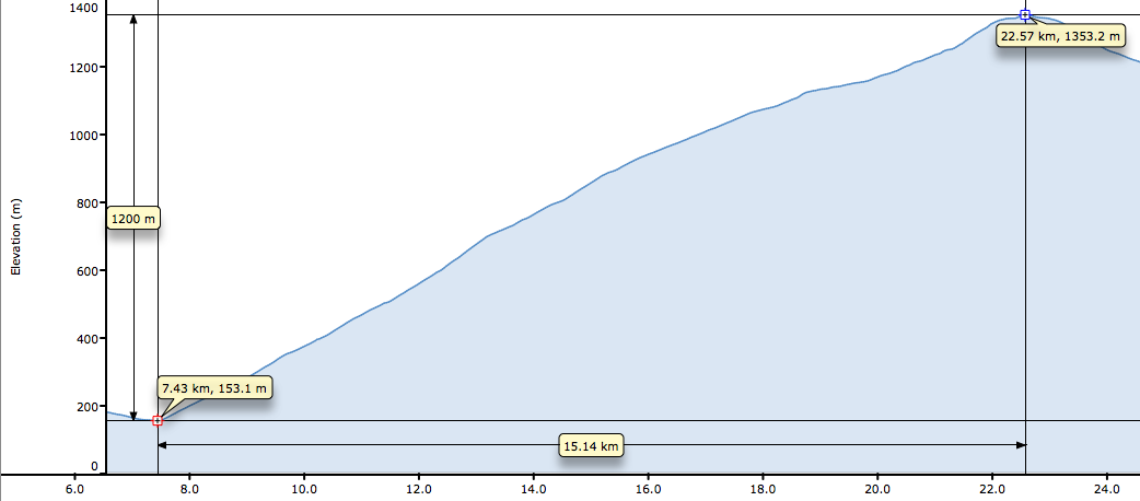
Elevation
The gradient

Wednesday, April 20, 2011

Monte San Simeone 2011

A beautiful Spring day, time to climb one of my all-time favorites- Monte San Simeone.
Long, easy, flat warm-up to Pinzano, then the rollers to Flagogna, and up the Strada di Bottecchia along the Tagliamento.  At Cornino, dozens of grifoni spiraled, glided and swooped along the cliffs of the nature reserve.  Some cruised over me low enough I could distinguish the colors and pattern of their underwing feathers, and their "bald" heads.  I had to pull over to watch this spectacle for awhile to avoid veering over the embankment.

At Interneppo, I turned right and climbed past the butterfly mural houses to the little pass above Bordano at 315m.  Here I turned left and began an easy ascent through the woods.  The road to Monte Feste forks to the left, but I continued more steeply to the right.  After a kilometer or so of prelude, the tornanti up the mountainside begin.  These are long switchbacks that climb at 10-14% along the rocky cliff-face, then double-back in short u- shaped tunnels at the eastern ends.  At the western ends, the road turns back above a vertical drop- off with wonderful views of Bordano, Monte Brancol to the south, and Lago Cavazzo.  This continues uninterrupted up to the transition onto the altopiano.  

The road now meanders its way steeply around and onto the grassy meadows, past a few little stone houses.  A group of parapendio riders ascended the thermals coming off the stone cliffs, starting below me and eventually floating far above in the sky.  At the end of pavement (1206m) I took a short walk up to Chiesa San Simeone, a small stone church dating from 1330.   Hard to imagine people living here back then, hiking the paths all the way up from Bordano, building stone churches, etc.

I rode down clutching the brakes, as the road is concrete and bumpy, with much fallen rock, branches etc.  There are no guardrails so margin of error is zero.  After the little pass at 315m enjoyed some nice fast curves down to Interneppo, then long downgrade to just north of Peonis.  A few rollers from here down through Cornino (grifoni were back in their nests) to Pinzano.  They were repaving the road from Pinzano toward Spilimbergo in preparation for next month's Giro d'Italia.  They also have repaved part of the Strada di Bottecchia- very nice.

Didn't bonk on the remaining flat cruise home, but fighting the headwind was a struggle with my rubbery legs.  I was so tired when I got home I took a hot soak and fell asleep.  Will sleep soundly tonight. 

Chiesa di San Simeone, consecrated in 1330 
Chiesa on the altopiano (1220m),
Monte Lavara (1908m) to the west in background
Looking north across the altopiano toward the summit
of Monte San Simeone,  1505 meters

The climb proper- 886 meters in 10 km, roughly 8.9% grade

Steepest bit is 21.2%, with a couple of near 20% stretches,
and much 12-14%

Good satellite view of altopiano and the summit to the northwest

Sunday, April 17, 2011

Malga Mezzomiglio - 2011

Today I rode up the eastern side of the Vittorio Veneto gorge, from Lago di Santa Croce to Il Cansiglio.  After parking at Vittorio Veneto, I rode up the easy climb to Sella di Fadalto (487m) and enjoyed seeing so many bike riders out.  After a quick roll down the east shore of Lago di Santa Croce, I turned right at Villaggio Riviera and started up the tornanti.  Beautiful views of the lake and not too steep. 

At Pianture (590m) the gradient becomes insane- 300 meters averaging 16%, with my Garmin showing 23.5% at the steepest point.  I rode this last year so knew what to expect: stand, pull up on the bars with each half-turn of the crank, inhale both with diaphragm and intercostals, exhale hard so you can suck in another lung-full immediately.   So it wasn't too bad.  After a brief flat bit, you start the worst part- a 6 km stretch which seems to never end.  There is one long straight stretch varying from 12-18%, with no switchback ends to recover in.  On the plus side the fir trees are gorgeous, with glimpses of the bluish-green lake far below.

Finally I entered the sunny meadows, still climbing steeply, until Malga Mezzomiglio, a rustic dairy with its own special cheese.  Lots of people have driven up for a Sunday visit.

I descended rapidly (and coldly) but took it easy in the curves- lots of loose stone.  At the lakeshore I turned south, awkwardly trying to pedal while frozen.  Finally at Fadalto I started the remaining descent, which is very fast because of the great pavement.  Driving home I saw hundreds of bikers- and a race marked off for the afternoon through the pavé streets of Vittorio Veneto- the 56th Frare De Nardi gara.   

View across the gorge- Col Visentin, left;
Monte Faverghera, center  

Watering hole in the meadows at 1200m;
the bowl valley of Alpago surrounded by
mountains in the background

The 23.5% grade at Pianture; note the other 18-19% stretches
8.85 km climbing 881 meters averaging 9.96% 

19 tornanti of the climb


Friday, April 15, 2011

Campioni del Ciclismo Moderno- Pordenone


Local cycling fans periodically share their extensive collections with the public.  Last year's show was Coppi-Bartali themed; this year it's a group of more recent champions: Anquetil, Gemondi, Merckx, Moser, Hinault, Indurain and Ballerini.


The exhibition was displayed in Convento di San Francesco, a restored 15th century nunnery.  I arrived punctually at opening time but it was locked, so I took some pictures of the lovely restored lunette frescoes.  Then I found the gate to the courtyard open (for access to a bar) and wandered among the arches and columns along the loggia.  I was surprised to find the doors open to the exhibit hall (the chapel of the convent), though the lights were out.  Shortly they came on so I started looking around.  A man appeared and asked how I got in- I explained and apologized.  He told me some things about the exhibit items, then left me alone with his collection while he went across the piazza to a bar.


The collection includes famous bikes, jerseys, tons of sports newspaper front pages (my favorite from July 1969 showed the moon landing headline in medium font, below a Merckx victory in huge typeface), sports magazines, cartoline, photos, palmares sheets, etc.  Pretty mindboggling.  There was also a video viewing room.   I only wish my friend Silvano would come up from Venezia before the exhibit closes next week- he'd love it.


Convento di San Francesco

Gemondi's Bianchi, Italian champion jersey and maglia rosa 

Moser's bike (note the oddly-shaped time-trial frame behind it)

Indurain's giro road bike (the frame sticker said Oria tubing, so
it's before the 1995 Dyna-Lite). 

Indurain giro time-trial bike

Left, Indurain's hour record bike from Barcelona;
right, another of his giro time-trial bikes

Indurain maillot jaune and maglia rosa

Merckx jerseys

Gemondi jersey

Moser jersey

Merckx jersey

Pedemonte-Colalto 2011

Planned a long ride but the previsione said it would rain in the afternoon.  So I picked a quick one- the 1200 meter climb up Piancavallo to Colalto.

After an 8km roll down Via Pedemontane (160m), I turned right and hit the 8-10% wall.  This  mellows to 8% for awhile, then returns to 12-14% for a lengthy stretch below Rifugio Bornass (767m).  I remained seated almost the whole time, which made my right glute quite sore, so had to stretch it some.  Continuing on up 10-12%, then mellowing to 6-7% on the remaining climb to Caldastia (1090m).  Here I turned onto the beautiful backroad to Colalto.  Climbs through lovely grassy meadows above the escarpment, until nearing the the ridge of Colalto, where it tilts upward to 11-14% through beech forest.  The road levels out at 1353 meters.

I donned my windjacket and headed down the mountain, gingerly at first on the rocky back road to Caldastia, faster on the wider but somewhat rough main road to Bornass, then full speed down the new pavement to the bottom.  Hit 76 kph on the steep 12-14% stretch, which was fun.

At the bottom they were paving Via Pedmontane up to Costa, so it will be nice and smooth from now on.  Great ride and didn't feel very tired when I got home less than 3 hours after starting.  Decided to go to the cycling champions exhibit in Pordenone in the afternoon (see next post).


1200 meter climb in 15km for 7.9% average grade